The Republic of Trinidad and Tobago is an archipelagic state in the southern Caribbean, lying northeast of the South American nation of ► Venezuela and south of ► Grenada in the Lesser Antilles. It also shares maritime boundaries with ► Barbados to the northeast and ► Guyana to the southeast. The country covers an area of 5,128 square kilometres (1,979 sq mi) and consists of two main islands, Trinidad and Tobago, and 21 smaller islands. Trinidad is the larger and more populous of the main islands; Tobago is much smaller, comprising about 6% of the total area and 4% of the population.
Short name
Trinidad and Tobago
Official name
Republic of Trinidad and Tobago
Status
Independent country since 1962 Republic since 1976
Location
Caribbean
Capital
Port of Spain
Population
1,359,193 inhabitants
Area
5,131 square kilometres (1,981 sq mi)
Major languages
English (official), Trinidadian Creole, Tobagonian Creole, and Trinidadian Hindustani
The WIKIMEDIA COMMONS Atlas of the World is an organized and commented collection of geographical, political and historical maps available at Wikimedia Commons. The main page is therefore the portal to maps and cartography on Wikimedia. That page contains links to entries by country, continent and by topic as well as general notes and references.
Every entry has an introduction section in English. If other languages are native and/or official in an entity, introductions in other languages are added in separate sections. The text of the introduction(s) is based on the content of the Wikipedia encyclopedia. For sources of the introduction see therefore the Wikipedia entries linked to. The same goes for the texts in the history sections.
Historical maps are included in the continent, country and dependency entries.
The status of various entities is disputed. See the content for the entities concerned.
The maps of former countries that are more or less continued by a present-day country or had a territory included in only one or two countries are included in the atlas of the present-day country. For example the Ottoman Empire can be found in the Atlas of Turkey.


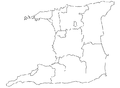 Regional corporations
 Arima
Arima Chaguanas
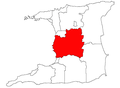 Couva-Tabaquite-Talparo
 Diego Martin
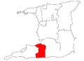 Penal-Debe
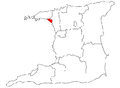 Port of Spain
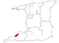 Point Fortin
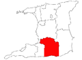 Princes Town
 Rio Claro-Mayaro
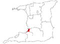 San Fernando
 Sangre Grande
 Siparia
 San Juan-Laventille
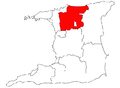 Tunapuna Piarco


