
-
 28606 Hits
-
 85.87% Score
-
 21 Votes
|
|
Mountain/Rock |
|---|---|
|
|
42.75725°N / 20.14392°E |
|
|
Hiking, Mountaineering, Trad Climbing, Sport Climbing |
|
|
Spring, Summer, Fall, Winter |
|
|
7884 ft / 2403 m |
|
|
Overview
Other Names: Maja e Hajles, HajlëIntro
Hajla is a mountain situated on the border between the state of Montenegro and Kosovo (a region, formally a part of Serbia, with still uncertain political future) and belongs to the North-Eastern part of Prokletije mountain range (Bjeshket e nemuna or Bjeshkët e Alpeve Shquiptare - Accursed Mountains).
Actually, with the height of 2,403 m it is the highest mountain of this part of Prokletije. Many people consider Hajla to be one of the most beautiful mountains of Montenegro.
  |
Position and Borders
Prokletije mountain range is situated at the south-eastern end of Dinaric mountain chain and it is here where, because of tectonic influences, Dinarics gradually diverge from their classical, so called Dinaric direction (NW-SE), into SW-NE direction, typical for Prokletije. Prokletije run for the most of their length in this direction. In Bogićevica mountain area they diverge more to the north untill they reach app. the area around Čakor (Qokorr) mountain and the mountain pass of the same name, after which all the mountains north of Čakor and Pećka Bistrica river valley diverge again from main Prokletije´s direction and run in eastern direction in this North-Eastern part of Prokletije (with mountains of Hajla, Žljeb (2,352 m) with Maja Rusolija (2,382 m), Mokra gora (2,155 m) with Suva planina (1,750 m), and other smaller mountains).
Hajla mountain runs in NW-SE direction. The mountain is bounded from south by Peć-Čakor road and Pećka Bistrica river valley (Lumebardhi, Lumi Bardh, Bistrica e Pejës, Lumbardh e Pejës – The White river) – a mountain river that makes famous 25 km long Rugova gorge (Gryka e Rugoves, Rugovska klisura) and which separates Hajla from Lumbardhit mountains (Ljumbardske planine, Bjeshka e Lumbardhit, 2522 m), situated more to the south and a part of Eastern Prokletije.
One of the largest tributaries of Pećka Bistrica and also a natural border of Hajla along its south-eastern slopes is Alagina Reka river (Rekë e Allages, Reka e Alags - Alaga´s river). On the other side of this river are southern slopes of neighboring Ahmica-Štedim (2,272 m) mountain.
The outermost south-western and western slopes of Hajla descend into the valley of Bogska Rijeka (the river of Bogë) which separates Hajla from Glođija (Glodjisja) and Mokra gora mountains and also two villages of Rugova area (Haxnaj/Hađovići and Stankaj/Jošanica) that are not placed on the slopes of Hajla. West of Hajla are
To the north, slopes of Hajla gradually descend to Ibar river valley and to the town of Rožaje basin.
Along the north-eastern foothills of Hajla runs Rožaje-Peć main road (Rožaje-Bukelj section) that connects Montenegro with Kosovo region and its Metohija basin, across Kula mountain pass and the border crossing of the same name.
 |
Geology and Morphology
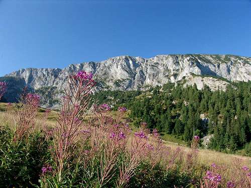
Hajla has complex structure; it is built of limestone and volcanic rocks, which caused variety of relief and countryside formations: rocky ridges, scenic passes, valleys, grassy slopes, forests, streams.
Higher peaks are predominantly built of limestone, mostly of Triassic Limestone (Triassic= 199-251 milion years ago), and partly of Perm (251-300 million y.a.) and Carbon rocks (300-360 million y.a.). But on many locations on higher parts of the mountain, limestone is mixed with eruptive rocks. This combination of limestone (carbonates) mixed with volcanic rocks has also reflected to diversity of living flora on Hajla.
Lower parts are formed of hornstone (a siliceous stone, a variety of quartz, closely resembling flint, but more brittle; called also chert) and tufa (volcanic ash cemented into spongy-like rocks).
Some parts of Hajla have rounded slopes, which is typical for mountains composed of silicate or eruptive rocks.
During Pleistocene period (0.01-1.8 million years ago) Hajla was covered with many glaciers descending toward valleys of Ibar and Pećka Bistrica, and of which many recesses still remain on both northern and southern side.
Northern part of the mountain is reshaped by many Ibar river tributaries and southern side by tributaries of Pećka Bistrica river.
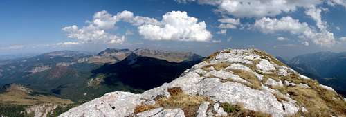
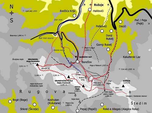
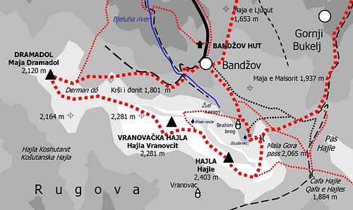
The most recognizable part of Hajla is its 10-12 km long main mountain ridge, elongated and in shape of a gently curved letter "s". Generally, it rises above 2,200 meters and stretches from Krstac mountain pass (on west) to Mala gora (or Donja ćafa) mountain pass on its eastern end.
Some parts of Hajla are given different local names. Starting from its western part, Hajla´s ridge consists of more parts and summits, starting from west: Škreljska Hajla (Shkrel´s Hajla 2,011 m) - Maja Dramadol (2,120 m), Košutanska Hajla (Hajla Koshutanit – Koshutan´s Hajla), Vranovačka Hajla (Hajla Vranovcit – Vranovac´s Hajla 2,281 m) and finally Hajla summit (2,403 m).
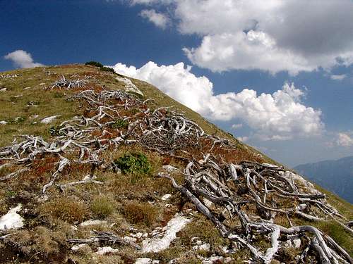
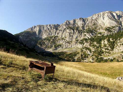
The summit of Hajla, 2,403 m high, is situated at the eastern end of the main mountain ridge. The ridge on this point is sometimes just about 1 meter wide. Stretching along the ridge´s north-eastern end and bellow the main summit is a 400 m high sheer limestone cliff, attractive and suitable for alpinist climbs. This cliff is especially dangerous in winter, open to wind squalls and covered with ice. Below this cliff is a plateau (1,810 m) called Brahim breg with water source and abandoned shepherds´huts.
Just 30 minutes away from the summit, and north of Vranovačka Hajla by the mountain path Brahim breg – Žuti kamen – Hajla summit, at the height of 1,980 m there is a small but inexhaustible spring with troughs for cattle watering, called Biser voda (literally translated as gem, jewel – water).
Water streams run down from Hajla in two dominant directions northern and southern, and collect into two main rivers: Ibar and Pećka Bistrica which belong to two different watersheds: The Black Sea watershed (all waters of northern slopes of Hajla and Ibar river), and the Adriatic sea watershed (waters of southern slopes of Hajla and the river of Pećka Bistrica).
Picturesque Ibar river source (Vrelo Ibra) is situated in deep forests of northern Hajla´s slopes, below its Maja Dramadol peak (2,120 m), in western part of the main mountain ridge. Actually, this is not the real beginning od Ibar river, because the waters come to this spring up from three larger sources and many smaller flowing down the slopes of Hajla before they join and come out as a single river source. After coming out of its spring Ibar flows for 30 kilometers through Montenegro (scenic gorges) before it enters Serbia. It finally ends its life in Serbia by confluenting into Western Morava river, after 183 km in total, counting from its source.
Ibar is fast mountain river. One of the strongest right tributaries to Ibar Ibarac also springs from northern Hajla´s slopes.
To approach Ibar river source one must use the same approach road used to reach Bandžov village and Bandžov mountain hut, 10-12 km away from the town of Rožaje.
 |
Rugova (Rugovo) Region
While the territory to the north of the mountain ridge of Hajla belongs to Rožaje region of Montenegro and to wider Sandžak area, southern slopes of Hajla, in Kosovo, belong to the region known as Rugova (Rugovo). More precisely, Rugova is situated between Lumbardhit mountains and Pećka Bistrica river on the south, Hajla´s main mountain ridge to the north, Ahmica-Štedim mountain and Alagina Reka to the east and Glođija, Murgaš mountain area and Bogska Rijeka to the west.
Rugova area is approximately 20 km long (in E-W direction) and 10 km wide (in N-S direction). Inhabitants of Rugova, predominantly ethnic Albanians (Kosovars) live in 13 main settlements, the most of them are situated on southern slopes of Hajla. These 13 Rugova´s villages are: Shtupeq i Vogël (Mali Štupelj – Small Shtupeq), Shtupeq i Madh (Veliki Štupelj – Large Shtupeq), Rekë e Allages (Alagina Reka), Malaj (Malevići), Drelaj (Drelje), Pepaj (Pepići), Kuqishtë (Kućište), Haxnaj (Hađovići), Stankaj (Jošanica), Bogë (Boge), Shkrel (Škrelje), Dugaivë (Dugajve, Dugonjiva) and Koshutan (Košutane). The houses of villages of Rugova (especially Upper Rugova) sometimes reach the height of 1,600, which is above upper forest line and already in pasture areas, covered with fileds and meadows. Above this height there are more periodical (summer) shepherd´s settlements known as katuns.
People that settle on all slopes of Hajla are mostly Albanians, Montenegrin and Bosnians (South Slavic Muslims). Many of them lived and still lived of stock-breeding and forestry. But seasonal shepherds´ migration into periodical summer huts and settlements high up in the mountain are becoming more and more infrequent, and today this tradition is stronger just on southern, Kosovo side of Hajla, where there are still more active seasonal dwellings for shepherds.
 |
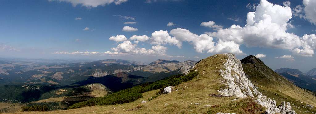
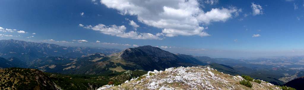
Summit Views
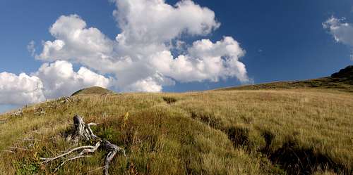
Views from Hajla´s summit are open and wide in all directions, because the highest ridge is exposed, rising high above surrounding slopes and plateaus and is also treeless.
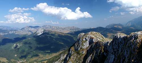
In south-eastern direction the view is dominated by mountains around Plav-Gusinje valley, then those above the Upper Lim river valley (Čakor, Visitor (2,211 m), Zeletin (2,126 m)) and further away by by the highest parts of Central Prokletije - mountains on Montenegrin-Albanian border (Maja Rosit, Maja Kolata, Karanfili) and further away in Albania (on very clear days).
In southern direction slopes od Hajla descent in more steps into Rugova gorge (gorge formed by Pećka Bistrica river), and from the other (southern) side of the gorge one can see more high mountains of the Eastern Prokletije rising as a row of high mountains, starting from left (east): Koprivnik/Koprivniku/Maja e Kopranikut, Lumbardhit mountains (Guri i Kuq/Žuti kamen (2,522 m), Liqinati/Neđžinat) and behind them more high peaks like Bogdaš-Marjaš/Marjash Starac/Staraci (2,426 m), Bogićevica and Maja Rops/Majae e Ropsit (2,501 m), Gjeravica/Đeravica (2,656 m). On southern slopes of Hajla, from the summit you can see the most of Rugova area, with its 13 villages spreaded around.
 |
South-east of Hajla, across Alagina reka depression and still high peaks of southern part of Ahmica-Štedim mountain (as are Crni vrh (1,964 m) and – Maja e Vjeljakut/Volujak, 2,015 m)) you can see wide plains of Metohija basin in western Kosovo, south of the town of Peja/Peć.
To the East of the summit of Hajla, across Ćafa Hajle mountain pass, there is a view on small but nice group of mountains: Ahmica-Štedim (2,272 m), Rusolija (2,382 m), Žljeb (2,352 m) and further away Mokra gora.
To the North-East the highest mountain on horizon is Kopaonik and Rogozna.
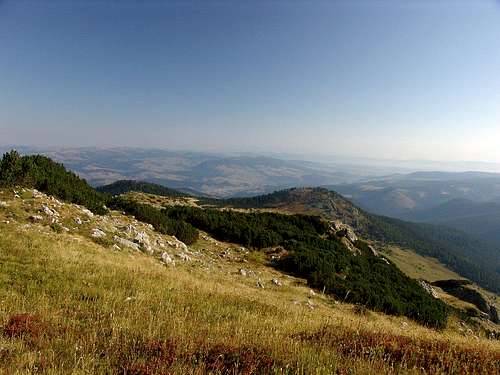 |
Northern views from Hajla are somewhat different from the others, because there is no high and dominant mountain here, but many lower laying mountains like Vlahovi (with peaks Gradina, Krstača 1,756 m and other), Giljeva (1,617 m). Further away to the North is vast, flat Pešter highland in southern Serbia. More to the north, behind Pešter are mountains of Stari Vlah and Raška regions of Srbia: Golija (1,833 m) and Javor (1,519 m).
North-western view: adjoining Hajla to NW is Cmiljevica mountain (1,963 m), behind is Divljak (1,728 m) and further away lower highlands and mountains of Bihor area, around Lim river valley in the vicinity of the towns of Berane and Bijelo Polje.
 |
Western view: Mokra planina, Lim river valley and behind rising high, large Bjelasica massif (Crna glava peak 2,139 m) and to the left (south) attractive rocky peaks of Komovi massif 2,478 m).
Climbs Overview
Most climbs to Hajla are gentle and very picturesque.
Main trail-head for climbs to Hajla is the town of Rožaje in Montenegro, situated north of Hajla. The secondary one is the town of Peja (or Pejë, Peć) SE of Hajla, in Kosovo region.
Generally, you can drive from Rožaje to get closer to Hajla by using one of two approaches:
1. By driving main road from Rožaje, first in south-western direction (direction of Berane), when you exit Rožaje, turn left by Ibar river bridge to non-paved road toward Ibar river source, a again to left to Bandžov village, following a traffic sign.
One of the first houses you will see when entering the village of Bandžov is Bandžov mountain hut (1,479 m).
From Bandžov village continue in SE direction following marked path if you want to climb, the summit of Hajla over Brahim breg plateau, and in SW direction if you plan to climb Dramadol peak in western part of Hajla (From Dramadol, nice 2-hour walk along the ridge in SE direction to Vranovačka Hajla and then 30 minutes more to reach the summit).
There are also two possibilities to climb Hajla summit from Brahim breg (via Mala gora pass or by the ridge via Žuti kamen area and over Vranovačka Hajla). From Mala gora turn south upwards to reach the mountain ridge, its easternmost part overlooking Qafa Hajles. When you reach the ridge turn right to NE to reach the summit.
2. By paved road Rožaje-Kula-Peć (Peja-Pejë), then after 8 km from Rožaje get off this road by a forester swing-gate (at 1,234 m alt.) in Bukelj Donji (Lower Bukelj) village and then follow Bukeljska rijeka (river) by driving non-paved forest road through coniferous forests for 2-3 km to get to Upper Bukelj (Gornji Bukelj 1,450 m) village area. You can continue further by vehicle to Pas Hajla area where you can leave yout car to climb Mala gora mountain pass. Here you meet another marked mountain path coming from your right side, from Brahim breg, Bandžov village, and Bandžov mountaineering hut. From Mala gora follow the path described in item 1.
From Bandžov, or Upper Bukelj village area (both around 1,400 m alt.) there is 2,30 – 3 hours of walk to climb another thousand meters needed to climb the summit of Hajla. If you have 4x4 vehicle you can approach Hajla even further - to 1 to 1,5 hours walking distance from the summit.
Beside previously mentiones approaches, you can also choose to walk all the way from Rožaje in Hajla direction, in more directions:
1.Rožaje – Halilovići – Bandžov – Hajla, summit
2.Rožaje – Peškovići – Gornji Bukelj – Rugovsko groblje – Hajla, summit
Climbs from Rožaje can take up to 5-6 hours.
It is possible to climb Hajla also from its southern side, from south (Rugova) and from SE. The starting point is the town of Peja (Peć) on Kosovo. From Peja there are more possibilities:
1. Peja – Maja e Vjeljakut (Volujak, 2,014 m) – Glođanski stanovi – Štedim (6 to 7 hours). This route was marked many years ago and the marks have almost completely faded.
2. Peja – Kućište – Boge (from Kućište 6 km by road) – Maja Dramadol (2,120 m) – Hajla summit (5-6 hours from Boge)
3. Peja (by Peja Čakor paved road) – Drelje – Košutane - Maja Dramadol – Hajla summit (5-6 hours).
4. Peja (by Peja Čakor paved road) – Drelje (village 12 km away from Peja) – Pepići – Hajla Keće (Stanovi) - Qafa Hajles (Hajles pass, Hajla pass) – Hajla summit.
 |
 |
Getting There
Getting to Rožaje by carApproaches and some distances:
Main roads lead from Rožaje into three directions: Berane (and further away to Podgorica, Plav, Mojkovac, SW Serbia, Eastern Bosnia; southern Croatia), Peć/Peja (and further to Prishtine/Priština, Macedonia and Albania), Ribarić (Kosovska Mitrovica, Novi Pazar and further away in Serbia)
Podgorica – Kolašin 71 km – Mojkovac 21 km – Berane 53 km – Rožaje 29 km – In Total Podgorica- Rožaje = 174 km
Podgorica – Mateševo 62 km – Andrijevica 45 km – Berane 17 km – Rožaje 29 km – In Total Podgorica- Rožaje = 153 km (shorther but in worse condition than Podgorica-Rožaje via Kolašin and Mojkovac)
From Rožaje to Ribarić (Serbia) 35 km – to Novi Pazar 65 km
Getting there by bus
There are regular bus connections to/from Rožaje to/from following destinations and directions: Podgorica (Berane, Montenegro), Novi Pazar up to 4 times daily (Beograd, Serbia), Sarajevo (Bosnia and Herzegovina), Peć (Kosovo)
Getting there by train
No railway passes thorug Rožaje or its vicinity. The closest is Belgrade-Bar railway and the station Bijelo Polje on it (with 6-8 trains daily from Podgorica and Belgrade) on it. From Bijelo Polje (58 km away from Rožaje) you can catch a bus (via town of Berane) to reach Rožaje.
Getting there by plane
There are no international airports in the vicinity of Hajla. The most convenient airports you can use are Podgorica Airport (cca 180 km away), and Tivat Airport (cca 240 km) both in Montenegro, Prishtine/Priština Airport (90 km) on Kosovo, Skopje Airport (cca 180 km) in Macedonia, Belgrade Airport in Serbia and Dubrovnik Airport in Croatia.
 |
 |
Red Tape
No special fee is needed and there are no special restrictions in the area. Hajla mountain is shared by two different countries so be aware that you are always close to the state border. Although you will very rarely notice border patrols, it is always recommended to register in advance at the police station in Rožaje - especially if you stay for more than a day and if your intention is to sleep in the mountain. It is also possible to climb Hajla from southern side, from Kosovo. Because of its uncertain political status, the area is full of foreign military, international observers and human aid workers, but there is still liberty of movement, just be aware to take care of your personal belongings, especially of your cars that can sometimes be stolen - because of the lack of the state of law in some areas, especially close to larger towns.Be aware of extreme weather conditions such are: thick snow-layer in winter, many foggy days or days when the mountain is completely covered with clouds throughout the year, and finally avalanches, especially in early spring, on days when warm southern winds suddenly set in motion thick snow-layers on steep and treeless slopes of Hajla.
 |
Camping & Accomodatiom
There is one active mountain hut in the village of Bandžov (at 1,479 m), built in 2003. and maintained by Jelenčica mountaineering club from Rožaje. It can accommodate up to 35 persons. Running water, electricity. It is possible to camp by the hut. You can approach the hut by a non-paved road or by foot (as it is already described in Routes Overview Section).You can walk from the hut in more directions, by using more trails, most of them marked. Some distances from Bandžov mountain hut are:
Bandžov - Derman dô (Derman valley) 2 h
Bandžov - Dramadol (Drmandol) summit (2,120 m) 3 h
Bandžov - Biser voda (spring) 3,30 h
Bandžov - Hajla 3,30 min (via Brahim breg)
Bandžov - Gropa (spring ) 1 h
Bandžov – Ibar source 5,7 km by non-paved road.
Hikers sometimes camp on Brahim breg plateau with a view to high rocks under the summit of Hajla, on its northern side. You can also ask locals to camp by shepherd´s mountain huts. You may offer to pay for using the place but many times local people woud not accept to be paid for this. You can f.e. buy some cheese or other local products in return, or giving some sweets to their´s always curious children would be very nice.
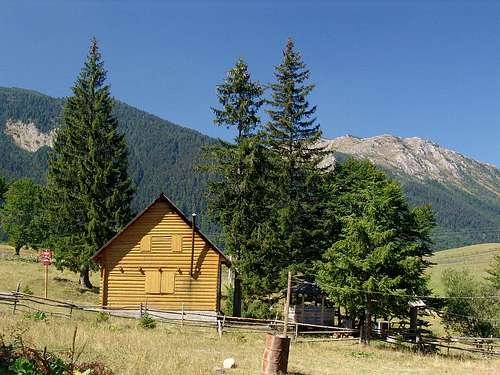 Maja Dramadol peak (2,120 m) behind in the background |
When to Climb
Hajla region belongs to continental mountain climate type and Alpine type in higher parts and in deep valleys. These types of climate are characterized by cold and long winters, and mild, sometimes fresh summers – and very often with fresh summer nights.Snow can sometimes fall even during summer months (July, August) but don’t expect serious snowfalls and lasting snow layer before October. Snow layer (October to April, even May) can be thick and very often 1 to 2 m high and even more. Many mountain passes in the area, especially those on non-paved roads are inaccessible during all winter months and many times, during some fall and spring months, too. Snow layer persists longer on northern slopes and in deep forests of this part of the mountain.
Precipitation periods are unevenly distributed throughout the year. The largest amount of rainfall is during spring and fall months, and fallings can sometimes last for weeks. These periods abound in foggy days, too. Generally, summer is short and rainy. There are fewer rainfalls during summer then in spring, but they can be very aboundant and very often followed by hail. Early morning fogs are frequent, rising over mountain slopes and covering the peaks of Hajla. Summer temperatures are mild to warm but the air is humid thanks to large forests covering the area.
Winds in this area can be very strong but they usually do not last for long. Coldest are north-eastern, northern and western winds, coming from inland and neighboring mountain areas. Just to inform you that north of Rožaje and of Hajla is the a high mountain plateau called Pešter, which is one of the coldest areas in this part of Europe with maximum minimal temeperatures measured at almost -40 degrees centigrade! This is a real natural freezer, just 20 km north of Rožaje. Since March in the area prevailing wind are southern and the western one, known here locally as "fat wind". It blows over Hajla and Cmiljevica, it is warm, humid and brings thick rainy clouds. Under influence of humid and warm wind the snow melts rest. Some partions of snow topple dow into deeper ravines where it stays until summer.
 |