Wikimedia Commons Atlas of the World

The Wikimedia Atlas of the World is an organized and commented collection of geographical, political and historical maps available at Wikimedia Commons.
Discussion • Update the atlas • Index of the Atlas • Atlas in categories • Other atlases on line
The introductions of the country, dependency and region entries are in the native languages and in English. The other introductions are in English.


Atlas of Africa
Africa
English Africa
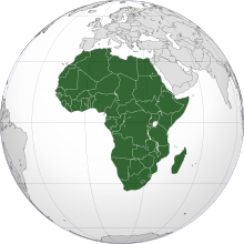
Africa is the world's second largest and second most-populous continent, after Asia. At about 30,221,532 km² (11,668,545 mi²) including adjacent islands, it covers 6.0% of the Earth's total surface area, and 20.4% of the total land area. With more than 890,000,000 people (as of 2005) in 61 territories, it accounts for about 14% of the world's human population. The continent is surrounded by the Mediterranean Sea to the north, the Suez Canal and the Red Sea to the northeast, the Indian Ocean to the southeast, and the Atlantic Ocean to the west.
Français Afrique

L' Afrique est le second continent au monde par sa population et le second (ou le 3è selon que l'on considère l'Amérique comme un ou deux continents) par sa superficie, après l’Asie. D’une superficie de 30.221.532 km² en incluant les îles adjacentes, l’Afrique couvre 6,0 % de la surface du globe terrestre, et 20,3 % de la surface des terres émergées. Avec une population de 900.000.000 habitants (en 2005), les Africains représentent 14% de la population mondiale. Le continent est bordé par la Mer Méditerranée au nord, le Canal de Suez et la Mer Rouge au nord-est, l’Océan Indien au sud-est et l’Océan Atlantique à l’ouest. L’Afrique comprend 46 pays en incluant Madagascar, et 53 en incluant tous les archipels.

العربية [1]أفريقيا وتسمى كذلك"القارة السمراء"، هى ثاني أكبر قارة بالعالم بعد آسيا. يحيطها البحر الأبيض من الشمال والبحر الأحمر والمحيط الهندي من الشرق والمحيط الأطلنطي من الغرب وفي أقصي شمال شرقها تتصل بآسيا براً في شبه جزيرة سيناء. وأفريقيا قارة متعددة الثقافات وبها مئات اللغات المختلفة. و العديد من القري بها مازالت تعيش عيشة بدائبة لم تتطور منذ مئات السنين.
Kiswahili Afrika

Afrika ni bara kubwa la pili duniani. Bara hili lina eneo la kilometa za mraba 30,244,050 na zaidi ya wakazi milioni 800. Asia ndio bara pekee kubwa kushinda Afrika.

Português África

A África é o segundo continente mais populoso da Terra (atrás da Ásia) e o segundo continente mais extenso (atrás da Ásia). Tem cerca de 30 milhões de km², cobrindo 20,3 % da área total da terra firme do planeta e mais de 800 milhões de habitantes em 54 países, representando cerca de um sétimo da população do mundo.

Population 890,000,000 inhabitants
Area 30,221,532 km²
Major language(s) French, English, Arabic, Swahili, Portuguese
Major religion(s) Islam, Roman Catholicism, Animism, Protestantism
More information Africa, Geography of Africa, History of Africa and Politics of Africa
More images Africa - Africa (Category).

General maps

Political map
Carte politique
Political map with 1st level divisions as of 1998 in SVG format
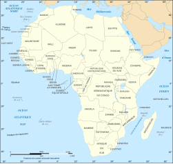
Political map (in French)
Carte politique
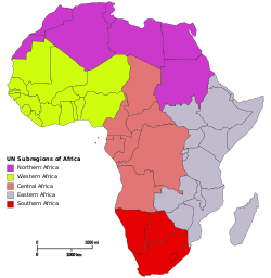
subregion of Africa:
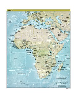
Physical map of Africa
Carte physique de l'Afrique
Geographical map
Carte géographique
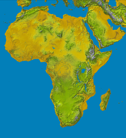
Topology map
Carte topologique
Blank Map of Africa
Fond de carte de l'Afrique (avec frontières étatiques depuis le 9.7.2011)

Maps of the Middle East

  Location of the Middle East
Localisation du Moyen-Orient
الشرق الأوسط
  Middle East
Moyen-Orient
الشرق الأوسط
  Middle East
Moyen-Orient
الشرق الأوسط

Current events

  The Middle East conflict 2006
  Israel and members of the Arab League (Comoros is not shown)

History maps

This section holds a short summary of the history of the area of present-day Africa, illustrated with maps, including historical maps of former countries and empires that included present-day Africa.

  Discovery sites of the Australopitecines
  Location of remains of Wilton culture (6000 BCE)
  Orient 2000 BC
  Map of the Ancient Near East during the Amarna period, showing the great powers of the period: Egypt (green), Hatti (yellow), the Kassites kingdom of Babylon (purple), Assyria (grey), and Mittani (red). Lighter areas show direct control, darker areas represent spheres of influence. The extent of the Achaean/Mycenaean civilization is shown in orange.
  Pre-colonial civilizations
  Oriental empires 600 BC
  Africa in the 13th century
  Africa around 1400
  Africa around 1400: kingdoms and trade routes
  Africa in the 15th century
  The Ghana Empire
  The Mali Empire
  The Songhai Empire
  Explorations of Africa 1857-1863
  Northwestern Africa in 1912
  Colonial Africa in 1913
 
Belgium
 
France
 
Germany
 
Great Britain
 
Italy
 
Portugal
 
Spain
 
Independent States
  Colonial Africa in 1914
  Mandates of the League of Nations
  Map with African independence dates
  Animated map of independence

Old maps

This section holds copies of original general maps more than 70 years old.

  Africa in 1508
  Africa in 1570 (Ortelius)
  Africa in 1595 (Mercator)
  Map of Africa, ca. 1630
  Africa in 1648 (Blaeu)
  West Africa, 1707 (Guillaume Delisle)
  Map of Africa by Herman Moll, 1710
  Map of West Africa by Herman Moll, 1729
  Africa in 1737
  West Africa, 1738
  Africa in 1808
  Map of Africa in 1812
  Map of Eastern Africa, 1829
  Routes of European explorers in Africa, to 1853
  Africa in 1861
  Ottoman map of Africa
  Senegambia, Andrees Allgemeiner Handatlas, 1st Edition, Leipzig (Germany) 1881, Page 96, Map 1.
  Map of Africa in 1890
  Map of Africa in 1897
  Map of Africa in 1898
  Maps in French showing the share of the Lunda kingdom in South-Western Africa (Schrader, Prudent, Anthoine)
  Map of Africa in the 1910s
  German claims in 1917

Maps of international organizations

  Union africaine
African Union
الاتحاد الأفريقي
União Africana
Umoja wa Afrika
  Historical development
  African Economic Community
  Regional pillars of the African Economic Community
  Active regional pillars
  Other trade blocs in Africa
  جامعة الدول العربية
Arab League
  L'Union du Maghreb Arabe
Arab Maghreb Union
  Conseil de l'Entente
Conseil de l'Entente
  Communauté économique des États de l'Afrique de l'Ouest

Comunidade Económica dos Estados da África Ocidental
Economic Community of West African States

  Currency co-operation in ECOWAS
  Southern African Development Community
Communauté de développement d’Afrique australe
Comunidade para o Desenvolvimento da África Austral
  L'Union du Maghreb Arabe
Arab Maghreb Union
  Communauté des Etats Sahélo-Sahariens
تجمع دول الساحل والصحراء
Community of Sahel-Saharan States
  Commission de l'Océan Indien
Indian Ocean Commission
  Marché commun de l'Afrique orientale et australe
Mercado Comum da África Oriental e Austral
Common Market for Eastern and Southern Africa
  Jumuiya ya Afrika ya Mashariki
East African Community
Communauté d'Afrique de l'Est
  Communauté Économique des États d'Afrique Centrale
Economic Community of Central African States
  Indian Ocean Rim Association for Regional Cooperation
  جامعة الدول العربية


Jāmaʻat ad-Duwwal al-ʻArabiyya
Arab League
:

Population maps - Cartes démographiques

  50 largest metropoles of Africa
Les 50 metropoles les plus grandes de l'Afrique
  Population density
Densité de la population

Ethnic and language maps

  Languages of Africa
Carte linguistique
Tale van Afrika
  Ethnic groups
Groupes ethniques
  Language map
Carte linguistique
  Official languages
  Afrique francophone
Francophone Africa
  Map showing the approximate distribution of Bantu (dull yellow) vs. other Niger-Congo languages languages and peoples (bright yellow).
  One common hypothesis of the Bantu expansion
  Nilo-Saharan languages
Langues nilo-sahariennes
  Khoi-San languages
  Afro-Asiatic languages
Langues afro-asiatiques

Economical maps

  National GDP per capita ranges from wealthier states in the north and south to poorer states in the east. These figures from the 2002 World Bank are converted to US dollars.
  High index values, indicated by lighter colors, show the relative poverty of African countries as ranked by the UNDP's 2004 list of countries by quality of life.

Satellite maps

  Satellite map of Africa
Carte satellite de l'Afrique

Other maps

  Map of Africa coloured according to the percentage of the Adult (ages 15-49) population with HIV/AIDS. Colour chart available in description.
  Africa, top left, populating the other continents in the Paleolithic.
  Map in French of Sahara in the Neolithic "wet period", 5000 years ago.

Notes and references

General remarks:

  • The WIKIMEDIA COMMONS Atlas of the World is an organized and commented collection of geographical, political and historical maps available at Wikimedia Commons. The main page is therefore the portal to maps and cartography on Wikimedia. That page contains links to entries by country, continent and by topic as well as general notes and references.
  • Every entry has an introduction section in English. If other languages are native and/or official in an entity, introductions in other languages are added in separate sections. The text of the introduction(s) is based on the content of the Wikipedia encyclopedia. For sources of the introduction see therefore the Wikipedia entries linked to. The same goes for the texts in the history sections.
  • Historical maps are included in the continent, country and dependency entries.
  • The status of various entities is disputed. See the content for the entities concerned.
  • The maps of former countries that are more or less continued by a present-day country or had a territory included in only one or two countries are included in the atlas of the present-day country. For example the Ottoman Empire can be found in the Atlas of Turkey.
  1. No romanization available.

Entries available in the atlas

General pages
Atlas   ■ Historical atlas   ■ Index of the Atlas   ■ Names in native languages

The world and its continents and oceans
Quick reference   ■ Historical maps of the world   ■ Old maps
Physical and topographical   ■ Political   ■ Geological   ■ People   ■ Time and time zones   ■ Projections of the globe
Africa   ■ North and South America   ■ Antarctica   ■ Asia   ■ Europe

(History, European Union)   ■ Oceania   ■ Oceans

Themes
Administrative divisions   ■ International organizations   ■ Languages   ■ Religions

Historical eras
Prehistory   ■ Antiquity   ■ Middle Ages   ■ Rise of Islam   ■ Early Modern Age   ■ Early American Societies   ■ Early Asian Societies   ■ Age of Renaissance   ■ Colonialism   ■ Stielers Handatlas 1891   ■ 20th Century   ■ World War I   ■ World War II

Entities with undisputed sovereign status
Afghanistan   ■ Albania   ■ Algeria   ■ Andorra   ■ Angola   ■ Antigua and Barbuda   ■ Argentina   ■ Armenia   ■ Australia   ■ Austria   ■ Azerbaijan   ■ Bahamas   ■ Bahrain   ■ Bangladesh   ■ Barbados   ■ Belarus   ■ Belgium   ■ Belize   ■ Benin   ■ Bhutan   ■ Bolivia   ■ Bosnia and Herzegovina   ■ Botswana   ■ Brazil   ■ Brunei   ■ Bulgaria   ■ Burkina Faso   ■ Burundi   ■ Cambodia   ■ Cameroon   ■ Canada   ■ Cape Verde   ■ Central African Republic   ■ Chad   ■ Chile   ■ China   ■ Colombia   ■ Comoros   ■ Congo (Democratic Republic)   ■ Congo (Republic)   ■ Costa Rica   ■ Côte d’Ivoire   ■ Croatia   ■ Cuba   ■ Cyprus   ■ Czech Republic   ■ Denmark   ■ Djibouti   ■ Dominica   ■ Dominican Republic   ■ East Timor   ■ Ecuador   ■ Egypt   ■ El Salvador   ■ Equatorial Guinea   ■ Eritrea   ■ Estonia   ■ Eswatini   ■ Ethiopia   ■ Fiji   ■ Finland   ■ France   ■ Gabon   ■ Gambia   ■ Georgia   ■ Germany   ■ Ghana   ■ Greece   ■ Grenada   ■ Guatemala   ■ Guinea   ■ Guinea-Bissau   ■ Guyana   ■ Haiti   ■ Honduras   ■ Hungary   ■ Iceland   ■ India   ■ Indonesia   ■ Iran   ■ Iraq   ■ Ireland   ■ Israel   ■ Italy   ■ Jamaica   ■ Japan   ■ Jordan   ■ Kazakhstan   ■ Kenya   ■ Kiribati   ■ Korea (Democratic People’s Republic)   ■ Korea (Republic)   ■ Kuwait   ■ Kyrgyzstan   ■ Laos   ■ Latvia   ■ Lebanon   ■ Lesotho   ■ Liberia   ■ Libya   ■ Liechtenstein   ■ Lithuania   ■ Luxembourg   ■ Madagascar   ■ Malawi   ■ Malaysia   ■ Maldives   ■ Mali   ■ Malta   ■ Marshall Islands   ■ Mauritania   ■ Mauritius   ■ Mexico   ■ Micronesia (Federated States)   ■ Moldova   ■ Monaco   ■ Mongolia   ■ Montenegro   ■ Morocco   ■ Mozambique   ■ Myanmar   ■ Namibia   ■ Nauru   ■ Nepal   ■ Netherlands   ■ New Zealand   ■ Nicaragua   ■ Niger   ■ Nigeria   ■ North Macedonia   ■ Norway   ■ Oman   ■ Pakistan   ■ Palau   ■ Panama   ■ Papua New Guinea   ■ Paraguay   ■ Peru   ■ Philippines   ■ Poland   ■ Portugal   ■ Qatar   ■ Romania   ■ Russia   ■ Rwanda   ■ Saint Kitts and Nevis   ■ Saint Lucia   ■ Saint Vincent and the Grenadines   ■ Samoa   ■ San Marino   ■ São Tomé and Príncipe   ■ Saudi Arabia   ■ Senegal   ■ Serbia   ■ Seychelles   ■ Sierra Leone   ■ Singapore   ■ Slovakia   ■ Slovenia   ■ Solomon Islands   ■ Somalia   ■ South Africa   ■ South Sudan   ■ Spain   ■ Sri Lanka   ■ Sudan   ■ Suriname   ■ Sweden   ■ Switzerland   ■ Syria   ■ Tajikistan   ■ Tanzania   ■ Thailand   ■ Togo   ■ Tonga   ■ Trinidad and Tobago   ■ Tunisia   ■ Turkey   ■ Turkmenistan   ■ Tuvalu   ■ Uganda   ■ Ukraine   ■ United Arab Emirates   ■ United Kingdom   ■ United States   ■ Uruguay   ■ Uzbekistan   ■ Vanuatu   ■ Vatican City   ■ Venezuela   ■ Vietnam   ■ Yemen   ■ Zambia   ■ Zimbabwe

Entities with disputed sovereign status
Abkhazia   ■ Artsakh   ■ Kosovo   ■ Northern Cyprus   ■ Palestine   ■ Somaliland   ■ South Ossetia   ■ Taiwan   ■ Tatarstan   ■ Transnistria   ■ Western Sahara

Dependencies and other overseas territories
Akrotiri and Dhekelia   ■ Åland   ■ American Samoa   ■ Anguilla   ■ Aruba   ■ Ascension Island   ■ Ashmore and Cartier Islands   ■ Baker Island   ■ Bermuda   ■ Bouvet Island   ■ British Indian Ocean Territory   ■ British Virgin Islands   ■ Cayman Islands   ■ Christmas Island   ■ Clipperton Island   ■ Cocos (Keeling) Islands   ■ Cook Islands   ■ Coral Sea Islands   ■ Curaçao   ■ Faroe Islands   ■ French Guiana   ■ French Polynesia   ■ French Southern and Antarctic Lands   ■ Gibraltar   ■ Greenland   ■ Guadeloupe   ■ Guam   ■ Guantanamo Bay   ■ Guernsey   ■ Heard Island and McDonald Islands   ■ Hong Kong   ■ Howland Island   ■ Isle of Man   ■ Jan Mayen   ■ Jarvis Island   ■ Jersey   ■ Johnston Atoll   ■ Kingman Reef   ■ Macau   ■ Martinique   ■ Mayotte   ■ Midway Atoll   ■ Montserrat   ■ Navassa Island   ■ New Caledonia   ■ Niue   ■ Norfolk Island   ■ Northern Mariana Islands   ■ Palmyra Atoll   ■ Pitcairn Islands   ■ Puerto Rico   ■ Réunion   ■ Saint Helena   ■ Saint Martin (France)   ■ Saint-Barthélemy   ■ Saint-Pierre and Miquelon   ■ Sint Maarten (Netherlands)   ■ Svalbard   ■ Tokelau   ■ Tristan da Cunha   ■ Turks and Caicos Islands   ■ United States Virgin Islands   ■ Wake Island   ■ Wallis and Futuna

Disputed subnational entities and territories
Bajo Nuevo Bank   ■ Crimea   ■ Falkland Islands   ■ Gilgit–Baltistan   ■ Kurdistan (Syrian)   ■ Kashmir   ■ Ladakh   ■ Paracel Islands   ■ Serranilla Bank   ■ South Georgia and South Sandwich Islands   ■ Spratly Islands   ■

Subnational autonomous entities
Aceh   ■ Adjara   ■ Adygea   ■ Altai   ■ Andalusia   ■ Aosta Valley   ■ Aragon   ■ Asturias   ■ Athos   ■ Azores   ■ Balearic Islands   ■ Bashkortostan   ■ Basque Autonomous Community   ■ Bonaire   ■ Bosnia and Herzegovina (Federation of)   ■ Bougainville   ■ Brussels   ■ Buryatia   ■ Canary Islands   ■ Catalonia   ■ Chechnya   ■ Chuvashia   ■ Corsica   ■ Dagestan   ■ Easter Island   ■ England   ■ Extremadura   ■ Flanders   ■ Friuli-Venezia Giulia   ■ Gagauzia   ■ Galicia   ■ Galápagos Islands   ■ Gilgit–Baltistan   ■ Gorno-Badakhshan   ■ Guangxi   ■ Ingushetia   ■ Islamabad Capital Territory   ■ Inner Mongolia   ■ Kabardino-Balkaria   ■ Kalmykia   ■ Karachay-Cherkessia   ■ Karakalpakstan   ■ Karelia   ■ Khakassia   ■ Komi   ■ Kurdistan (Iraqi)   ■ Khyber Pakhtunkhwa   ■ Madeira   ■ Mari El   ■ Muslim Mindanao   ■ Mordovia   ■ Nakhichevan   ■ Navarre   ■ Nevis   ■ Ningxia   ■ North Ossetia – Alania   ■ Northern Ireland   ■ Nunatsiavut   ■ Quebec   ■ Saba   ■ Sakha   ■ Sardinia   ■ Scotland   ■ Sicily   ■ Sindh   ■ Sint Eustatius   ■ Srpska   ■ Tibet   ■ Tłı̨chǫ   ■ Trentino-Alto Adige   ■ Tuva   ■ Udmurtia   ■ Vojvodina   ■ Wales   ■ Wallonia   ■ Xinjiang   ■ Zanzibar

Other regions
Basque Country   ■ Burzenland   ■ Catalan Countries   ■ Frisia   ■ Kurdistan   ■ Manchuria   ■ Sápmi   ■ Svenskfinland   ■ Székely Land   ■ Transylvania

Former sovereign nations
Austria-Hungary   ■ Byzantine Empire   ■ Caliphate   ■ Czechoslovakia   ■ Frankish Empire   ■ Kingdom of Hawaiʻi   ■ Inca Empire   ■ Iroquois Confederacy   ■ Macedonian Empire   ■ Ottoman Empire   ■ Prussia   ■ Roman Empire   ■ Soviet Union   ■ Republic of Texas   ■ Vermont Republic   ■ Republic of West Florida   ■ Yugoslavia

Former dependencies and overseas territories
Netherlands Antilles

Former disputed territories
Tamil Eelam