Atlas of Belize

|
Wikimedia Commons Atlas of the World The Wikimedia Atlas of the World is an organized and commented collection of geographical, political and historical maps available at Wikimedia Commons. Discussion • Update the atlas • Index of the Atlas • Atlas in categories • Other atlases on line |
|
| ||||||||||||||||||||||||||||||||||||||


General maps

|
Map of Belize |

|
Map of Belize |

|
Map of Belize |

|
Map of Belize |

|
Map of Belize |
Maps of divisions
This section holds maps of the administrative divisions.

|
Districts of Belize |

|
Constituencies of Belize |
-
 District Belize
 -
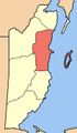
 District Cayo
 -
 District Corozal
 -
 District Orange Walk
 -
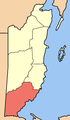
 District Stann Creek
 -
 District Toledo


History maps
This section holds a short summary of the history of the area of present-day Belize, illustrated with maps, including historical maps of former countries and empires that included present-day Belize.

|
Present-day Belize was for a long time part of the Maya Empire. The Maya civilization flourished until about 1200. |

|
This map shows the Maya civilization compared with present states. |
| European contact began in 1502 when Christopher Columbus sails along the coast. The first recorded European settlement was begun by shipwrecked English seamen in 1638. Over the next 150 years, more English settlements are established. The area becomes formally a British colony as British Honduras in 1840. In 1862 British Honduras becomes administrative part of Jamaica, which it remains until 1884. Between 1954 and 1959 British Honduras has internal self-government. Between 1959 and 1961 the colony is under direct administration of the British government. In 1964 British Honduras achieves full internal self-government. Nine year later, in 1973, the colony is renamed Belize. |
| In 1981 Belize becomes an independent parliamentary democratic monarchy. |
Old maps
This section holds copies of original general maps more than 70 years old.

|
Map of British territory in the Yucatan from 1787 |

|
Map of British territory in the Yucatan from 1790 |

|
Map of British territory in the Yucatan from 1840 |

|
Map of British territory in the Yucatan from 1855 |

|
Map of British Honduras from 1864 |
.jpg)
|
Map of British Honduras from 1888 |
Other maps

|
Maya languages |

|
Map of British Honduras from 1965 |
Satellite maps

|
Satellite image from 2002 |
Notes and references
|
General remarks:
|