Commons:Graphic Lab/Map workshop
| Illustration Workshop | Map Workshop | Photography Workshop | Video and Sound Workshop |
 Map workshop
This workshop is part of the Graphics Lab, a project aimed at picture retouching to improve the graphical content of the Wikimedia projects. More information about the lab can be found on its main page and requests pages (Illustrations ; Photographs ; Maps ; Video and Sound). To ask questions or make a suggestions, see the talk page of the graphic lab page.
This specific page is the requests page for the Map Workshop. Anyone can make a request for a map to be created or improved. The standard format for making a request is shown below, along with general advice, and should be followed.
Make a request
Use the following template when making a new request, replacing the examples with your image(s) and request(s):
<gallery>
 IMAGENAME.EXT|Description of image
 IMAGE#TWO.EXT|2nd image (If there is one)
 ETCETCETC.EXT|Don't request too many at once, though
</gallery>

;Request:
: Details of your request go here… --~~~~
;Graphist opinion(s):
See also edit
| SpBot archives all sections tagged with {{Section resolved|1=~~~~}} after 7 days and sections whose most recent comment is older than 185 days. For the archive overview, see /Archive. The latest archive is located at /Archive/2024. | |
Simple map(s) of Finnish Defence Forces Areas of Responsibility from early 1950s edit
-
 A potential base map

Article(s): en:User:Ljleppan/Polttoainehankinta
- Request
- (Moved from Commons:File requests)
- I'm not certain what the best source map would be, but I'd appreciate a Commons-compatible version of the map of Figure 6 (page 37) of this PDF (also accessible via this link) for the draft currently at en:User:Ljleppan/Polttoainehankinta. In addition to the Areas of Responsibility, it would be good to show the locations of en:Helsinki, en:Porkkala and a few of the larger cities (Perhaps en:Turku, en:Vaasa, en:Oulu, en:Rovaniemi and en:Ivalo if possible without sacrificing legibility?).
- I'd also greatly appreciate Commons-version of the map(s) in Figure 5 (page 31) of the same PDF, but that's less of a priority.
- Graphist opinion(s)
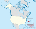
Puerto Rico edit
-
 Description of first image
_(US50)_(-grid).svg)
Article(s): Hawaiʻi on Wiktionary; A lot
- Request
- I suggest adding Puerto Rico to the United States, unless it's not part of the United States.
- Puerto Rico is part of the United States. People wonder why many Americans don't know it- well there's your answer. Just because "(US50)" appears in the title doesn't change how this image is actually used- see Hawaiʻi on Wiktionary. The caption there reads: "Hawaii in respect to the rest of the United States". You're giving people a stupid map that would need to be presented in a qualified way, and then that map is being used to imply that this is a map of the whole USA. You now get to choose whether WMF will continue to deceptively imply that Puerto Rico is somehow not part of the United States. Don't bring your decolonization ideological stuff at me when Russia still has Siberia and China has Tibet. As if! Yes Puerto Rico has got a special status. But they voted to become a state a few years ago (it wasn't accepted by the US Congress yet, this is just a fact that tends to discredit any "decolonization" ideological silliness). So Yes, it's the USA. Get off your high horse and show the people the full United States. --Geographyinitiative (talk) 22:26, 18 May 2023 (UTC)
- Graphist opinion(s)
- There are locator maps of Puerto Rico within the United States, similar to the above locator map of Hawaii. Take a look at the following maps:
-
 Puerto Rico in United States (zoom + special marker) (US49)
 -
 Puerto Rico in United States (zoom + special marker) (US49+1)
 -
 Puerto Rico in United States (zoom) (US49)
 -
 Puerto Rico in United States (zoom) (US49+1)
_(US49).svg)
_(US49%2B1).svg)
_(US49).svg)
_(US49%2B1).svg)
- Also, you should not blame WMF for ignoring Puerto Rico as part of the US. It is generally not shown along with the 50 states and the federal district as US overseas territories are excluded from most maps. There's no "decolonization" ideology whatsoever on this matter, just a matter of convention. --Sbb1413 (he) (talk • contribs) 16:52, 15 June 2023 (UTC)
- @Geographyinitiative: Sbb1413 (he) (talk • contribs) 15:51, 18 July 2023 (UTC)
- Pardon me, my comment above is a little bit intense! All I mean is that I feel that 1) if Puerto Rico appears on a map, 2) and the map does not show Puerto Rico as part of the USA, 3) then there should be a good reason, or a specific purpose for that map, rather than as a general map "of the USA". Hence I renew my request for the update to that map showing Hawai'i without showing Puerto Rico as part of the USA. --Geographyinitiative (talk) 16:16, 18 July 2023 (UTC)
- In Description of first image, the position of the Hawaiian Archipelago inside the box is wrong. The islands need to turned to their correct geographical position. --Multituberculata (talk) 20:38, 20 November 2023 (UTC)
Map of the Wash (Lincolnshire/Norfolk) edit
-
 Please create a SVG version of this map please.

Article(s):The Wash and various others
- Request
- Please can a SVG version of this map please be created of the Wash that goes around the Lincolnshire and Norfolk coastlines, in the new SVG version can the places listed on the PNG map be included in the new map along with the river outlines of the Witham, Welland, Nene and Great Ouse and the county boundary of both Lincolnshire and Norfolk and also to add some further information could some of the features of the wash be included like “The Lynn Channel”the “Boston Deeps” and the “Lynn Deeps”. (MOTORAL1987 (talk) 12:52, 31 August 2023 (UTC))
- Graphist opinion(s)
![]() Request taken by --please ping me-- Goran tek-en (talk) 11:23, 19 February 2024 (UTC)
Request taken by --please ping me-- Goran tek-en (talk) 11:23, 19 February 2024 (UTC)
- @MOTORAL1987 You will have to give me information regarding The Lynn Channel, I can't find it? --please ping me-- Goran tek-en (talk) 18:34, 19 February 2024 (UTC)
- @MOTORAL1987 Now I need more info from you, don't forget the Lynn Channel.
- Do you want the areas Blue and Green like in this draft, not final just to show.
- You can see them here also, aren't they important for this area? --please ping me-- Goran tek-en (talk) 16:43, 20 February 2024 (UTC)
- @MOTORAL1987 Now I need more info from you, don't forget the Lynn Channel.
MOTORAL1987 I'm not getting any feedback from you so now I have uploaded what I have. If you want anything changed just ping me, thanks.
Now you can find it here file:The Wash England.svg.
- Please check all the information, also links for wikipedia, wikidata and structured data.
- If you are happy with this please put the code
"{{section re.solved|1=~~~~}}"(without the ".") on this request so it can be archived, thanks. Done --please ping me-- Goran tek-en (talk) 14:56, 28 February 2024 (UTC)
- Hello there, I am sorry I haven’t been logged in for a while, thank you so much for working on the new image it is fantastic and a missive improvement on the old one. The only things I can think off that would round off the map perfectly would be the following
1. Please add the towns of Hunstanton and Downham Market onto the map.
2. Can the villages of Fosdyke (can the area known as the Fosdyke Wash also be mentioned too),Long Sutton and Sutton Bridge also be added to the map as they are important reference points on the Wash.
3. Please also add the location of the royal estate of Sandringham also be added onto the map as well please.
4 Can Cambridgeshire be labelled on the map as it is currently unmarked and added into the legend. Otherwise thank you so much.
(MOTORAL1987 (talk) 14:51, 2 March 2024 (UTC))
- Done (MOTORAL1987 (talk) 16:50, 3 March 2024 (UTC))
Create a SVG version of File:Topo 25 sheets orig.jpg edit
-
 Assembly map of for Swisstop 1:25,000 sheets.
 -
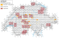


Article(s): Category:Swisstopo 1:25'000 map sheets
- Request
- Please create a SVG version of File:Topo 25 sheets orig.jpg. Only the external borders, the grid, and the sheet names are needed, while if the lakes and rivers can be included, it is nice. File:Cantons Suisses.svg or File:Switzerland adm location map.svg can be used as base map. The name of all sheets is available in Category:Swisstopo 1:25'000 map sheets. --Yann (talk) 20:48, 18 September 2023 (UTC)
- Graphist opinion(s)
![]() Done - I have created this SVG file which includes the lakes and rivers, the large sheets, and hyperlinks to the images on commons. Tbi1233 (talk) 20:57, 22 January 2024 (UTC)
Done - I have created this SVG file which includes the lakes and rivers, the large sheets, and hyperlinks to the images on commons. Tbi1233 (talk) 20:57, 22 January 2024 (UTC)
Taiwan Strait median line edit
-
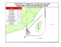 Example
 -
 Example

Article(s): Taiwan Strait
- Request
- There is no high quality map of the median line of the Taiwan Strait on Wikimedia Commons or on Wikipedia (the only ones I can find are these I've just uploaded and added here); such a map should be produced.
- (1) Here is a pdf that shows the median line of the Taiwan Strait: [2]. (2) Here is a discussion of the median line on Wikipedia: Taiwan_Strait#Median_line. (3) Here is a Wiktionary article with five reliable sources discussing the line: [3].--Geographyinitiative (talk) 18:33, 8 October 2023 (UTC)
- Graphist opinion(s)
Geographyinitiative So you want a svg version showing the Strait, without the different flight paths? --please ping me-- Goran tek-en (talk) 16:42, 26 November 2023 (UTC)
- @Geographyinitiative I need your feedback on my questions above, thanks. --please ping me-- Goran tek-en (talk) 15:50, 1 January 2024 (UTC)
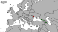
ethnic and linguistic maps of the Caucasus edit


Article(s): [[]]
- Request
- Please update these maps due to the w:flight of Nagorno-Karabakh Armenians. Initially, it would be better to mark this area as uninhabited, because according to the UN there are between 50 and 1,000 people left.
The second thing is to add a "spot" of Greeks near the city of w:Yessentuki to the first map.  --Swiãtopôłk (talk) 16:44, 16 October 2023 (UTC)
- All of Nagorno-Karabakh and the striped areas around it, need to be colored in striped green and white, because almost all Armenians fled the region in September/October 2023, but has still not been populated by Azerbaijani civilians in the striped areas, after Azerbaijan gained it in late 2020. The whole region is patrolled by Azerbaijani troops and police, who are the only human presence, hence why the whole region needs to be colored both in green and white stripes, rather than just in green or just in white. --Multituberculata (talk) 20:54, 20 November 2023 (UTC)
- Graphist opinion(s)
Current and former Marxist–Leninist states (North Korea to be striped) edit

Article(s): en:Marxism–Leninism and related pages.
- Request
- Add a rotated (45 degrees) stripe pattern to North Korea (red and dark red).
- To reflect the lack of consensus whether North Korea is still Marxist–Leninist or not. –Vipz (talk) 18:51, 22 October 2023 (UTC)
- Graphist opinion(s)
- DoneI have created an SVG map (Former & Current Marxist–Leninist states map.svg) per your request. Please let me know if this is incorrect. Thatautistichistorian (talk) 04:22, 8 January 2024 (UTC)
- Hello @Thatautistichistorian, thank you so much! This is what I asked for, however, North Korea seems to be missing altogether in thumbnails (which are rendered as PNG), but shows up fine when SVG is accessed directly. Do you know what's the issue and how to fix it? Cheers. –Vipz (talk) 20:02, 17 January 2024 (UTC)
- Hi @Vipz, this is the first time I have made an SVG map edit for Commons and am relatively new to Inkscape. Sorry but I don't know why it's doing that and how to fix it. Thatautistichistorian (talk) 05:31, 20 January 2024 (UTC)
- @Vipz nevermind just fixed it. its now updated on the file page. Thatautistichistorian (talk) 05:35, 20 January 2024 (UTC)
- Hi @Vipz, this is the first time I have made an SVG map edit for Commons and am relatively new to Inkscape. Sorry but I don't know why it's doing that and how to fix it. Thatautistichistorian (talk) 05:31, 20 January 2024 (UTC)
- Hello @Thatautistichistorian, thank you so much! This is what I asked for, however, North Korea seems to be missing altogether in thumbnails (which are rendered as PNG), but shows up fine when SVG is accessed directly. Do you know what's the issue and how to fix it? Cheers. –Vipz (talk) 20:02, 17 January 2024 (UTC)
Map of French Guyana in a book for Wikisource edit
-
 Current state of the map

Article(s): https://fr.wikisource.org/wiki/Aventures_en_Guyane
- Request
- Hi!
 Would it be possible to enhance this image? Similar to what has been done regarding this one for example : File:Belliou la Fumée - Hachette- page 17.jpg. This illustration will be on Wikisource in French. --Tpe.g5.stan (talk) 09:41, 26 October 2023 (UTC)
 - Graphist opinion(s)
- I edited the image like the other picture you linked, but some of the writing in the image is hard to read(even in the original), so if you want i could try making a higher resolution version and re write the text so that is is easier to read :3 Done Worm-b0y16 (talk) 12:48, 27 October 2023 (UTC)
- Thanks a lot !
- On republications of this book they have completely changed the map. It is most probably the editor's work anyway (the author has disappeared/died in the forest and the book was published posthumously). I do not think it will be necessary. Tpe.g5.stan (talk) 13:14, 27 October 2023 (UTC)

Update the Map edit
Data - https://dahd.nic.in/hi/related-links/annex-ii-8-gist-state-legislations-cow-slaughter
-
 status
 -
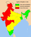 original


- Request
- Update the map and add the states like Uttar Pradesh, Madhya Pradesh in red. Data from [4]--103.241.226.199 06:23, 3 November 2023 (UTC)
- Both maps of India also need to include the new borders of the Union Territories of Jammu and Kashmir, and Ladakh, which were created in 2019, and the borders of the State of Telangana, which was created in 2014. --Multituberculata (talk) 19:19, 20 November 2023 (UTC)
- Graphist opinion(s)
Update map of NCAA D-I men's hockey locations edit
-
 Map showing the locations of all NCAA Division I men's college ice hockey teams

Article(s): en:List of NCAA Division I ice hockey programs
- Request
- This map needs to be updated with current locations listed at en:List of NCAA Division I ice hockey programs#Men
--R.L (talk) 17:54, 7 November 2023 (UTC)
- I have created an updated version of this map. I am not able to overwrite the previous file for some reason. The updated file is uploaded here: https://commons.wikimedia.org/wiki/File:Map_-_College_Hockey_-_all_men%27s_D-I_locations_-_2025.svg Kingkoch32 (talk) 20:49, 28 February 2024 (UTC)
- It appears I will be able to upload in 4 days. Kingkoch32 (talk) 20:55, 28 February 2024 (UTC)
- Graphist opinion(s)
3 images need fixing edit
-
 Artsakh needs removing
 -
 Saint Kitts and Nevis, Jamaica and Fiji need to be grey as they have no official Railways
 -
 Artsakh is being dissolved, Ukraine and Moldova have left Commonwealth of Independent States and CISFTA


- Article(s)
- en:International recognition of Abkhazia and South Ossetia, en:List of track gauges, en:Collective Security Treaty Organization
- Request
- (I have listed underneath the 3 images what needs fixing.) --HelpfulHens (talk) 16:54, 20 November 2023 (UTC)
- Graphist opinion(s)
Donetsk, Luhansk and Crimea edit
-
 Donetsk, Luhansk and Crimea absorbed themselves into Russia.

- Article(s)
- en:List of states with limited recognition
- Request
- (Donetsk, Luhansk and Crimea come up when I hover over them but they should come up as Ukraine as they dissolved themselves.) --HelpfulHens (talk) 16:59, 20 November 2023 (UTC)
- Graphist opinion(s)
- I don't see what you're referring to. M.Bitton (talk) 20:53, 7 January 2024 (UTC)
- @HelpfulHens Neither can I. --please ping me-- Goran tek-en (talk) 12:49, 8 January 2024 (UTC)
- When you hover the curser over Crimea and the Donbass, they showed up as Donetsk, Luhansk and Crimea. But they have since been corrected. HelpfulHens (talk) 21:56, 10 January 2024 (UTC)
Update of the maps of India, which need to include the borders of Jammu and Kashmir, Ladakh and Telangana. edit

.svg)
_(claims_hatched).svg)
_(disputed_hatched).svg)
.svg)

.svg)
.svg)
.svg)
.svg)
.svg)

.svg)
.svg)

.svg)
.svg)

.svg)

.svg)
.svg)
.svg)
.svg)
.svg)

.svg)
.svg)
.svg)

.svg)
.svg)
_(claims_hatched).svg)
_(disputed_hatched).svg)
.svg)

.svg)
.svg)

.svg)
.svg)

.svg)
.svg)

_(claims_hatched).svg)
.svg)
.svg)

.svg)
.svg)

.svg)
.svg)

.svg)
.svg)
.svg)
.svg)
.svg)
.svg)

.svg)
.svg)

.svg)
.svg)

.svg)
.svg)

.svg)
.svg)

.svg)
.svg)
_(claimed_and_disputed_hatched).svg)
_(claims_hatched).svg)
_(disputed_hatched).svg)
.svg)

.svg)
.svg)
.svg)

.svg)
.svg)
_(claims_hatched).svg)
_(disputed_hatched).svg)
.svg)

.svg)
.svg)

.svg)
.svg)

.svg)
.svg)

.svg)
.svg)

.svg)
.svg)

.svg)
.svg)

.svg)
.svg)

.svg)
.svg)

Article(s): Hundreds of articles across Wikipedia.
- Request
- The internal borders of India urgently need to be updated. The borders of the Union Territories of Jammu and Kashmir and Ladakh which were created in 2019, and the borders of the State of Telangana, which was created in 2014, need to be drawn in the maps of India, which are very widely used in hundreds of articles across Wikipedia. These maps are categorized under the Category:SVG locator maps of states in India (red location map scheme). --Multituberculata (talk) 19:41, 20 November 2023 (UTC)
- Graphist opinion(s)
Transnistria maps edit
-
 Artsakh needs removing
 -
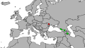 Artsakh needs removing


- Article(s)
- en:International recognition of Transnistria, en:Foreign relations of Transnistria
- Request
- I have added the info above.
- (details of your request go here...) --HelpfulHens (talk) 20:07, 20 November 2023 (UTC)
- Graphist opinion(s)
4 maps of Cuban municipalities with colouring pbms for islands edit
-
 1) Municipality of Morón in Ciego de Ávila province
 -
 2) Municipality of Bolivia in Ciego de Ávila province
 -
 3) Municipality of Esmeralda in Camagüey prov.
 -
 4) Municipality of Nuevitas in Camagüey prov.
.png)
.png)
.png)
.png)
Article(s): fr:Morón (Cuba), fr:Esmeralda (Cuba), fr:Nuevitas, fr:Bolivia (Cuba) (all already in use)
- Request
- Hello you people who do such wonderful work, can you please help with that one ? The pbms are with the colouring of the islands (red, yellow, or absence thereof). (The refs are all maps in openstreet showing the municipalities' limits and the islands' limits.)
- Start with checking on map 4 "Nuevitas" because the red colouring of the islands makes it easier to sort out. In that map, at that scale, we see roughly what looks like 4 of them red islands + a sort of peninsula west of them that's (righfully) attached to Nuevitas municipality by being in red too. Add to that the island in white, on the left of them red ones, and that gives the following list from west to east :
- cayo Coco, the island in white in map 4 and in red in map 1. It is with Morón[1]. This one has the proper colour in all 4 maps but I mention it in case you decide to spend some time checking what's what. Knowing what this one is, will help.
- cayo Romano Occidental[2]. It belongs to Morón[1], so :
- map 1: it should be in red (not in white).
- map 2: it should be in yellow (not in white).
- map 3: it should be in white (not in yellow).
- map 4: it should be in white (not in red).
- cayo Romano Oriental[2] is with Esmeralda[3]. It's the island that's got on its north side a long thin island which is cayo Cruz[4], so we can't get that one wrong. But also : it's taken me a while to sort out that the blob on its right, the one that looks (rather loosely) like an elephant with a bloated trump turned towards the left, is supposed to represent cayo Romano Oriental too (determined that by careful comparing of municipalities limits aligned with them cayos, + cayo Romano Oriental is almost 3 times the length of cayo Romano Occidental so that fits these maps too). So :
- map 1 and map 2: both blobs ok in white.
- map 3: both blobs should be in red (not in yellow).
- map 4: both blobs should be in yellow (not in red).
- Of course all the maps for all municipalities in Ciego de Ávila province and in Camagüey province also show the wrong colours for these islands but at least there is no red involved so it doesn't show so much. Besides that, in all the maps, Guáimaro municipality is shown to go all the way to the sea, which it doesn't (see fr:Guáimaro where I added a comment in that sense). For the municipalities in Camagüey province, each of them has a handy section "Municipalités voisines" with a table that gives links to all neighbouring places, + with the corresponding map in each, so you can jump from one to the next without having to go back to commons each time. I just finished that, will do Ciego de Ávila province next.
- Refs
- ↑ a b municipality of Moron, map
- ↑ a b cayo Romano, map. It is divided in two : cayo Romano Occidental (name shown in this map) in Morón, Ciego de Ávila; and cayo Romano Oriental (I'm adding the "Oriental" as implied from the other bit, the map gives no name for this one) in Esmeralda, Camagüey.
- ↑ municipality of Esmeralda, map.
- ↑ cayo Cruz, map
- ↑ cayo Guajaba, map.
- ↑ a b municipality of Nuevitas, map.
Many thanks to whomever will accept to take the time so sort out these 4 maps' colours. --Pueblo89 (talk) 05:59, 30 November 2023 (UTC)
- Graphist opinion(s)
![]() Request taken by --please ping me-- Goran tek-en (talk) 16:48, 28 January 2024 (UTC)
Request taken by --please ping me-- Goran tek-en (talk) 16:48, 28 January 2024 (UTC)
- @Pueblo89 I will create 4 new maps in svg as it's hard to see on the png's and it's a better format.
I will need your feedback in some time, will ping you, thanks. --please ping me-- Goran tek-en (talk) 17:05, 28 January 2024 (UTC)- @Pueblo89
- ----
- Those drafts are PNG versions of the original SVG file I'm working in and will upload to commons.
- Those drafts are shown for proofreading only.
- ----
- Hi, you really did a great organized request but now when I have a more detailed svg map like this
- Empty map draft it's very hard for me transfer your information. Also it seems like the municipals borders are a bit different on this svg map than on the png sources.
- Would it be possible for you in some way give me information for each of the four maps what to color with what without referring to the png's?
The links to OSM are great and I do understand it will be some work for you? --please ping me-- Goran tek-en (talk) 18:01, 28 January 2024 (UTC)- @Pueblo89 I really need to know if you will provide the needed info for me to complete the svg maps?
If not, I will have to withdraw my take as I can't help you then. --please ping me-- Goran tek-en (talk) 10:41, 3 February 2024 (UTC)
@Pueblo89: As I don't get any feedback from you I have to withdraw my take. --please ping me-- Goran tek-en (talk) 11:25, 11 February 2024 (UTC)
Hello Goran tek-en, all my apologies: I had to take a rather long leave of absence. Am half back now. Are you still around? Pueblo89 (talk) 15:06, 19 April 2024 (UTC)
- @Pueblo89 OK, hope you are all right, or on the way, respect that things do take time to recover from. Yes, we can continue but I will need your help/knowledge all the way. --please ping me-- Goran tek-en (talk) 16:29, 19 April 2024 (UTC)
Large svg map edit
-
Simplified (but not too simple) SVG of Canada's census divisions
-
Description of second image (if needed)
-
Description of third image (if needed; don't request too many at once, though)
-
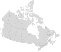 Finished map

Article(s): [[]]
- Request
- I have an extremely large (235 mb) svg file of Canada's census divisions. I downloaded the shapefile from [5] (it's freely licensed) and converted it to SVG. I can't simplify the paths on Inkscape without messing up the internal borders. What should I do to be able to upload it to Commons? --Kingofthedead (talk) 06:19, 6 December 2023 (UTC)
- Graphist opinion(s)
- @Kingofthedead: I assume that you're referring to the "census division" from the "Administrative boundaries". What do you mean by "messing up the borders"? How much simplification are you after? Is the map going to be shown by itself or as part of another bigger map with which it needs to align? M.Bitton (talk) 12:34, 6 December 2023 (UTC)
- @M.Bitton: I downloaded the "census divisions" shapefile from Administrative boundaries. I then converted it to svg. By "messing up the borders" I mean the internal borders become too simple, leaving white space in between. In reality I only want the extremely, unnecessarily detailed coasts which have a lot of nodes to be reduced. This is what it looks like when I use the "simplify" feature on Inkscape:

The purpose of uploading this map is to have a high-quality SVG file of all census divisions of Canada which includes all of Canada, similar to File:Blank USA map with counties.svg. Kingofthedead (talk) 05:03, 7 December 2023 (UTC)
- I'll see what I can do. M.Bitton (talk) 13:10, 9 December 2023 (UTC)
- Done @Kingofthedead: please check the finished map and let me know if I missed something, though please bear in mind that anything minor would have to wait until the new year. The instructions on how to use it are here. M.Bitton (talk) 14:42, 16 December 2023 (UTC)
Vectorize raster map file edit
-
 Raster map file

Article(s): en:Tren Maya
- Request
- Hi! Please vectorize this raster map file. Thank you! --OrdinaryScarlett (talk) 21:19, 24 December 2023 (UTC)
- Graphist opinion(s)
Fake SVG needs replacement edit
-
 Apparent fake SVG; locator map of Uzbekistan
 -
 Locator map of Tajikistan, for comparison
 -
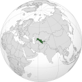 Finished map

.svg)
.svg)
Article(s): en:Uzbekistan
- Request
- Appears to be a fake SVG; needs to be urgently replaced by an authentic one matching the style of other maps in Category:SVG_locator_maps_of_countries_of_Asia_(gray_and_green_globe_scheme). --–LaundryPizza03 (dc̄) 04:40, 28 December 2023 (UTC)
- Graphist opinion(s)
- Please note that although this particular map seems is bad, not all so-called "fake SVG" maps are.
 Request taken by M.Bitton (talk) 19:35, 29 December 2023 (UTC)
 - Done @LaundryPizza03: I didn't overwrite the problematic map. M.Bitton (talk) 16:25, 30 December 2023 (UTC)
Keir Starmer Approval Graph edit

Article(s): en:Leadership approval opinion polling for the next United Kingdom general election
- Request
- Can someone please update this graph to the latest version using the information in the Keir Starmer section on the Wikipedia page linked above, which as of the time of writing stetches from April 2020 to 19 Sep 2023. Helper201 (talk) 19:55, 29 December 2023 (UTC)
- Graphist opinion(s)
Incorrect/missing colors of waterbodies edit

Article(s): en:Vironniemi
- Request
- The map above is just an example; there are probably 100+ of these maps with incorrect/missing waterbody colors on maps of Helsinki. File:Helsinki districts.svg is the base map file and has the correct coloring; please compare it to the image above. Those incorrect maps were made by User:Stadscykel who later fixed some of them (e.g. Special:Diff/43585007, Special:Diff/43585930), but most of those maps still have incorrect/missing colors. Related discussions on fi.wikipedia: link and link, and here on Commons: link. --JAAqqO (talk) 01:06, 31 December 2023 (UTC)
- Graphist opinion(s)
Update with source edit
-
 Description of first image
 -
Description of second image (if needed)
-
Description of third image (if needed; don't request too many at once, though)
.svg)
Article(s): [[]]
- Request
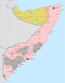
- An update is needed since a source from en:UNOSAT (link here) has given demarcation for the new state of north Somalia SSC-Khatumo. Could someone incorporate the UNOSAT source on Khatumo borders into the above map please? --Billboardbillal (talk) 10:48, 2 January 2024 (UTC)
- Graphist opinion(s)
Gautier, Jackson County, Mississippi edit

Article(s): w:Gautier, Mississippi
- Request
Hello, can someone please upload a new map of Jackson County, Mississippi, specifically one that includes w:Gautier, Mississippi, as the area of the city has increased? It would be a new version of File:Jackson County Mississippi Incorporated and Unincorporated areas Gautier Highlighted.svg. If it's not too difficult, someone could also upload new maps showing the other cities in Jackson County, Mississippi. Thanks! Kk.urban (talk) 22:45, 4 January 2024 (UTC)
- Graphist opinion(s)
Translate to English and vectorize German language map file edit
-
 Raster German language map
.png)
Article(s): en:South–North Water Transfer Project
- Request
- Hi! Please translate and vectorize this raster German language map file. Thank you! --OrdinaryScarlett (talk) 05:04, 9 January 2024 (UTC)
- @OrdinaryScarlett Graphic workers do not do translations, it's up to the requester to provide the translations in a way it's easy to work with, copy, see which goes where etc, thanks. --please ping me-- Goran tek-en (talk) 18:30, 13 January 2024 (UTC)
- Graphist opinion(s)
Piggly Wiggly locations map out-of-date edit
-
 This map is not up-to-date.

- Request
- Link: en:Piggly Wiggly
- Looking at pigglywiggly.com/store-locations/, they now have locations in New York and Texas, and don't have any in Missouri or Minnesota anymore. BhamBoi (talk) 04:27, 11 January 2024 (UTC)
- Graphist opinion(s)
Map colours edit

Article(s): en:Psilocybin decriminalization in the United States
- Request
- I think the colours for "Legal for medical use and decriminalized" and "Decriminalized" are quite similar and could lead to confusion, especially on small screens like mobiles and for people with sight and colour blindness and similar such issues. So, I think more different/distinct colours could be used for this map, taking into account colour blindness and sight issues and just generally be easier to distinguish between for everyone. Helper201 (talk) 17:30, 12 January 2024 (UTC)
- Graphist opinion(s)
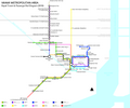
Create vector static map for commuter rail network edit
Article(s): en:Virginia Railway Express
- Request
- Hi! Please create a vector static map for this commuter rail network. Thank you! --OrdinaryScarlett (talk) 02:41, 13 January 2024 (UTC)
- P.S. Please use #eb1b23 for the Fredericksburg Line, and #1a458b for the Manassas Line. Thanks again! --OrdinaryScarlett (talk) 02:49, 13 January 2024 (UTC)
- @OrdinaryScarlett As it is the requester who has the knowledge about the subject and the graphic workers knows the graphic, it's common that the requester provides a good free source for the request. Graphic worker doesn't generally do research and reads a lot of text etc, thanks. --please ping me-- Goran tek-en (talk) 18:28, 13 January 2024 (UTC)
- Sure! A great source for the geographical data for both lines can be found at Data:Virginia Railway Express.map, which I made myself using the preexisting KML file attached to the Wikipedia article. I hope that's good enough? --OrdinaryScarlett (talk) 23:04, 13 January 2024 (UTC)
- Where is the east end of the red line? It just appears to merge with the blue one on http://commons.wikimedia.org/wiki/Data:Virginia_Railway_Express.map cmɢʟee ⋅τaʟκ 02:41, 16 January 2024 (UTC)
- The two merge together and both end at the same point; at Washington Union Station. Because of the way that these maps work, unfortunately you can only see one line over the other when they overlap. But yes, they both at the same point. --OrdinaryScarlett (talk) 05:46, 16 January 2024 (UTC)
- Where is the east end of the red line? It just appears to merge with the blue one on http://commons.wikimedia.org/wiki/Data:Virginia_Railway_Express.map cmɢʟee ⋅τaʟκ 02:41, 16 January 2024 (UTC)
- Sure! A great source for the geographical data for both lines can be found at Data:Virginia Railway Express.map, which I made myself using the preexisting KML file attached to the Wikipedia article. I hope that's good enough? --OrdinaryScarlett (talk) 23:04, 13 January 2024 (UTC)
- @OrdinaryScarlett As it is the requester who has the knowledge about the subject and the graphic workers knows the graphic, it's common that the requester provides a good free source for the request. Graphic worker doesn't generally do research and reads a lot of text etc, thanks. --please ping me-- Goran tek-en (talk) 18:28, 13 January 2024 (UTC)
- P.S. Please use #eb1b23 for the Fredericksburg Line, and #1a458b for the Manassas Line. Thanks again! --OrdinaryScarlett (talk) 02:49, 13 January 2024 (UTC)
- P.S. Again, but ideally a map similar to this would be preferable. Thanks again! --OrdinaryScarlett (talk) 00:18, 14 January 2024 (UTC)
- Graphist opinion(s)
Convert raster map files to a vector file edit
-
 Raster map file #1
 -
 Raster map file #2 (also needs to be updated)


Article(s): en:Corridor Cities Transitway and various South Florida rail articles
- Request
- Hi! Please convert this raster map file to a vector file. Thank you! --OrdinaryScarlett (talk) 23:27, 13 January 2024 (UTC)
- P.S. I added a second one. For the Downtown Miami Link service, please cut it back to Tri-Rail and Metrorail Transfer. Thanks again! --OrdinaryScarlett (talk) 00:20, 14 January 2024 (UTC)
- Graphist opinion(s)
New accurate map in SVG of the visa policy of the Democratic Republic of the Congo edit
-
 Example 1 : visa policy of South Africa
 -
 Example 2 : visa policy of Tunisia


Article(s):
- Request
- The current file for the visa policy of the Democratic Republic of the Congo is an old PNG, not up to do date and that does not even show eVisa. Please make one like South Africa or Tunisia as shown above. Thank you. -- Calvinsky (talk) 11:14, 19 January 2024 (UTC)
- Graphist opinion(s)
-
 This is originally created by Maxxl2 , I just corrected some location.But sadly it saved into PNG.

- Request
- Please convert the file extension from png into svg (without lossing colour and quality).--Lord Buddha 1 (talk) 12:09, 19 January 2024 (UTC)
- Graphist opinion(s)
New range maps for Bathytoshia stingrays to be used on en.wikipedia edit
-
A rangemap for Bathytoshia lata
-
A revised rangemap for Bathytoshia centroura
-
Description of third image (if needed; don't request too many at once, though)

Article(s): en:Broad stingray en:Roughtail stingray
- Request
- The old map is attached in the gallery. B. centroura is now only found in the Western Atlantic. The map for B. lata needs to include the portion removed from B. centroura and that included on its FishBase native range map [6]--Big Blue Cray(fish) Twins (talk) 15:41, 25 January 2024 (UTC)
- Graphist opinion(s)
Map of location of Capelle train accident edit
Article(s): en:Capelle train accident
- Request
- Please make a map like this map] to be used in the English and Dutch Wikipedia articles. The source is this PDF document, page 86. The arrow is at this address on OpenStreetMaps (here on Google Maps). Thanks in advance! --Wroeter (talk) 12:30, 28 January 2024 (UTC)
- Graphist opinion(s)
Cleaning up the SVG coding for a Massachusetts county map edit
-
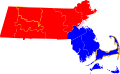 A map showing the current status of government each county in Massachusetts, based on information from Abolitions of some county governments section of the List of counties in Massachusetts article

Article(s): en:List_of_counties_in_Massachusetts
- Request
- I made a map based on the article information to visually show the status of county governments and government abolition. I used File:Map_of_Massachusetts_highlighting_Barnstable_County.svg as the base and edited the SVG coding, but it could definitely use some edits and love from someone more experienced with SVG to make it more visually appealing. --Gimelthedog (talk) 16:45, 28 January 2024 (UTC)
- Graphist opinion(s)
1934 Germany referendum results edit
Article(s): en:1934 German referendum
- Request
- I would really appreciate it if someone could make a map of the results of the 1934 Germany referendum. The results of the referendum are detailed here (in German), and it would use the same template as the other files in Category:Weimar Republic election maps. Thank you so much! HouseBlaster (talk) 01:23, 2 February 2024 (UTC)
- Graphist opinion(s)
- I can take this if someone can extract the data, convert in numeric format (table in wiki or some csv/excel file) and translate the columns. Once I have the data I can do the map. @HouseBlaster: would you agree or be able to do this?--Ikonact (talk) 13:01, 22 February 2024 (UTC)
 In progress HouseBlaster (talk) 16:20, 22 February 2024 (UTC)
Here we go:
| Region | Yes | No |
|---|---|---|
| East Prussia | 1,357,842 | 57,282 |
| Berlin | 995,199 | 226,216 |
| Potsdam II | 1,089,695 | 201,412 |
| Potsdam I | 1,340,262 | 154,674 |
| Frankfurt | 1,031,689 | 58,413 |
| Pomerania | 1,197,395 | 85,172 |
| Breslau | 1,122,219 | 117,683 |
| Liegnitz | 755,268 | 63,539 |
| Oppeln | 792,999 | 66,683 |
| Magdeburg | 1,026,554 | 99,856 |
| Merseburg | 884,377 | 78,753 |
| Thüringen | 1,433,433 | 121,803 |
| Schleswig-Holstein | 952,634 | 144,692 |
| Weser-Ems | 875,907 | 137,288 |
| Osthannover | 661,434 | 61,515 |
| Südhannover-Braunschweig | 1,217,938 | 111,444 |
| Westfalen Nord | 1,360,104 | 255,467 |
| Westfalen Süd | 1,407,713 | 209,149 |
| Hessen-Nassau | 1,572,556 | 146,490 |
| Köln-Aachen | 1,198,136 | 266,743 |
| Koblenz-Trier | 743,019 | 105,826 |
| Düsseldorf Ost | 1,272,263 | 143,187 |
| Düsseldorf West | 1,087,427 | 103,077 |
| Oberbayern-Schwaben | 1,667,002 | 166,722 |
| Niederbayern | 771,008 | 61,443 |
| Franken | 1,619,136 | 89,119 |
| Pfalz | 622,456 | 21,853 |
| Dresden-Bautzen | 1,201,010 | 105,568 |
| Leipzis | 764,625 | 133,711 |
| Chemnitz-Zwickau | 1,160,756 | 124,611 |
| Württemberg | 1,697,271 | 118,555 |
| Baden | 1,407,841 | 144,004 |
| Hessen-Darmstadt | 863,967 | 89,805 |
| Hamburg | 659,013 | 168,725 |
| Mecklenburg | 584,700 | 59,890 |
Pinging @Ikonact. Thanks again for taking this on! HouseBlaster (talk) 23:37, 24 February 2024 (UTC)
- @HouseBlaster First try here. Let me know about colours, details, whatever you would like to see different or add. Ikonact (talk) 09:19, 25 February 2024 (UTC)
- Thank you so much! Would it be possible to use {{Awmcphee's proposal support level color scheme}}? I am also not sure which Gau it is, but the 49.40 one seems to have the incorrect number. Again, thank you for taking this one on HouseBlaster (talk) 15:19, 25 February 2024 (UTC)
- @HouseBlaster I will correct. thanks. Just to be sure... if you want me to use the Awmcphee's proposal support level color scheme, I am afraid that most of the map will be very much the same dark blue. Is this what you want? Ikonact (talk) 16:23, 25 February 2024 (UTC)
- That is fair enough. Let's stick with the red. Again, thank you so much! HouseBlaster (talk) 16:24, 25 February 2024 (UTC)
- @HouseBlaster I uploaded a new version with Awmcphee's proposal support level color scheme. I did it already before seeing your message. I can revert to the red scheme or I can use also similar blue discrete scheme but change the intervals to 5% instead of 10% as in the Awmcphee's proposal support level color scheme. Let me know. Ikonact (talk) 16:47, 25 February 2024 (UTC)
- @Ikonact thank you! I personally like the blue; would you be able to try the 5% intervals? Best, HouseBlaster (talk) 16:52, 25 February 2024 (UTC)
- @HouseBlaster uploaded. let me know! Ikonact (talk) 16:58, 25 February 2024 (UTC)
- It looks fabulous. Thank you so much!! HouseBlaster (talk) 17:00, 25 February 2024 (UTC)
- @HouseBlaster OK, I will keep it and close the request. If you need other similar maps ping me :). Cheers Ikonact (talk) 17:02, 25 February 2024 (UTC)
- It looks fabulous. Thank you so much!! HouseBlaster (talk) 17:00, 25 February 2024 (UTC)
- @HouseBlaster uploaded. let me know! Ikonact (talk) 16:58, 25 February 2024 (UTC)
- @Ikonact thank you! I personally like the blue; would you be able to try the 5% intervals? Best, HouseBlaster (talk) 16:52, 25 February 2024 (UTC)
- @HouseBlaster I uploaded a new version with Awmcphee's proposal support level color scheme. I did it already before seeing your message. I can revert to the red scheme or I can use also similar blue discrete scheme but change the intervals to 5% instead of 10% as in the Awmcphee's proposal support level color scheme. Let me know. Ikonact (talk) 16:47, 25 February 2024 (UTC)
- That is fair enough. Let's stick with the red. Again, thank you so much! HouseBlaster (talk) 16:24, 25 February 2024 (UTC)
- @HouseBlaster I will correct. thanks. Just to be sure... if you want me to use the Awmcphee's proposal support level color scheme, I am afraid that most of the map will be very much the same dark blue. Is this what you want? Ikonact (talk) 16:23, 25 February 2024 (UTC)
- Thank you so much! Would it be possible to use {{Awmcphee's proposal support level color scheme}}? I am also not sure which Gau it is, but the 49.40 one seems to have the incorrect number. Again, thank you for taking this one on
![]() Done --Ikonact (talk) 10:08, 26 February 2024 (UTC)
Done --Ikonact (talk) 10:08, 26 February 2024 (UTC)
Update request for File:Europe countries map en 2.png edit
-
 File:Europe countries map en 2.png

Article(s): Many articles across Wikipedia.
- Request
- In File:Europe countries map en 2.png, the black coloring for Nagorno-Karabakh within the borders of Azerbaijan needs to be removed, because the de facto Republic of Nagorno-Karabakh ceased to exist after Azerbaijan took all of it and gained full control over its entire territory in 2023. (The same requests have also been made for the removal of Nagorno-Karabakh from the maps which include Azerbaijan by other users here in the Commons:Graphic Lab/Map workshop page, which are pending.) --Multituberculata (talk) 08:58, 4 February 2024 (UTC)
- Graphist opinion(s)
Update request for the linguistic and ethnicity maps of the Armenian language and the Armenian people edit
-
 File:Map-of-speakers-of-armenian.png – Nagorno-Karabakh needs to be removed
 -
 File:Idioma armenio.png – Nagorno-Karabakh needs to be removed
 -
 File:Idioma azerí.png – Nagorno-Karabakh needs to be colored in blue
 -
 File:Armenian distribution map.png – Nagorno-Karabakh needs to be colored in brown
 -
 File:ArmenianDiaspora.png – Nagorno-Karabakh needs to be removed
 -
 File:Diàspora armènia.png – Nagorno-Karabakh needs to be removed
 -
 File:Map of the Armenian Diaspora in the World.svg – Azerbaijan needs to be colored in gray as there are less than 1,000 Armenians after the flight of virtually all Armenians with the dissolution of Nagorno-Karabakh and Turkey needs to be colored in (+ 10,000) very light brown, as there are less than 100,000 Armenians


Article(s): Many articles across Wikipedia.
- Request
- These linguistic and ethnicity maps of the Armenian language and the Armenian people need to be updated after the Flight of Nagorno-Karabakh Armenians in 2023, which has resulted in the total ethnic cleansing of the Armenians from Nagorno-Karabakh and thus from all of Azerbaijan, after Azerbaijan took all of Nagorno-Karabakh. There is no Armenian community left anymore within Azerbaijan's internationally recognized borders. --Multituberculata (talk) 08:50, 12 February 2024 (UTC)
- Graphist opinion(s)
Fix thumbnail for File:Ocupação da Iugoslávia pelas forças do eixo 1941-1943.svg edit
-
 Map of Yugoslavia in WW2 in Portuguese.

Article(s): pt:Invasão da Iugoslávia
- Request
- I created this map last year, but I thought it was a bad file, but it seems only the thumbnail is brokenTet (talk) 13:40, 18 February 2024 (UTC)
- Graphist opinion(s)
- Done M.Bitton (talk) 19:44, 18 February 2024 (UTC)
Fix the map for JF-17 jet users edit
-
 Map with JF-17 jet airplane operators in blue, loctaed on the following Wikipedia page

Article(s): [[]]
- Request
- Add Azerbaijan as highlighted in blue. Azerbaijan signed a contract to purchase these airplanes. --Creffel (talk) 12:15, 22 February 2024 (UTC)
- Graphist opinion(s)
Suicide legislation edit
-
 Suicide legislation world map

Article(s): en:Suicide legislation
- Request
- There are changes and corrections that should be made to this map. Firstly, Morocco and Syria should be in grey, as there is no cited information on the above linked Wikipedia page to say suicide is illegal in either country (as the map currently claims). Secondly, Chile and Cuba should be in green as suicide is cited as legal in both, while assisted is suicide illegal. Helper201 (talk) 01:35, 29 February 2024 (UTC)
- Graphist opinion(s)
Update request for the Indonesia Ethnic Groups Map edit
-
 Map of ethnic groups in Indonesia in Russian
Article(s): en:Ethnic groups in Indonesia
- Request
- Is there anyone here who would like to make revisions, additions, and also make an English version of this map? I already have a list of things that need to be revised and updated, but I will mention these things in stages considering the length of the list I have. Note: I already have the name labels on this map in English and Indonesian, so you don't need to translate them anymore, just write them on the map. --Ibrahim Muizzuddin (talk) 08:19, 3 March 2024 (UTC)
- Graphist opinion(s)
Visa Policy Map of Turkmenistan Visa Policy edit

Article(s): Name of article the image will be used in to link on English Wikipedia: Visa Policy Of Turkmenistan for Non-Ordinary Passports
- Request
- Hi, was just hoping if anyone can update the map by adding Singapore into the list of visa-exempt countries for Diplomatic and Official/Service Passport Holders as map is outdated. For more information on the single change required, you can try to text me at Suomi2023 but I am not always online. Thank you.
- Graphist opinion(s)
![]() Done --Rtfroot (talk) 18:31, 14 March 2024 (UTC)
Done --Rtfroot (talk) 18:31, 14 March 2024 (UTC)
Make a map of the Middle Corridor based on the map from the official website edit
Article(s): en:Middle Corridor
- Request
- Please someone make a map of the Middle Corridor based on the map from the official site --Rtfroot (talk) 18:25, 14 March 2024 (UTC)
- Graphist opinion(s)
- Request taken by — Meghmollar2017 • Talk • 06:30, 19 March 2024 (UTC)
- Hi! Thank you for taking this. Any progress? Rtfroot (talk) 14:43, 24 March 2024 (UTC)
- Done @Rtfroot: Hello, sorry for the late. Please check the map out if it needs fixing. Regards — Meghmollar2017 • Talk • 12:56, 29 March 2024 (UTC) (Please ping me)
- @Meghmollar2017 Oh, thank you very much, such a great job! Everything is fine, but the original map is a little outdated. Kazakhstan renamed its capital from Nur-Sultan to Astana. Rtfroot (talk) 17:41, 29 March 2024 (UTC)
- @Rtfroot, I have uploaded a new version of the map with the new name. Thanks. : ) — Meghmollar2017 • Talk • 06:53, 30 March 2024 (UTC)
- @Meghmollar2017 Oh, thank you very much, such a great job! Everything is fine, but the original map is a little outdated. Kazakhstan renamed its capital from Nur-Sultan to Astana. Rtfroot (talk) 17:41, 29 March 2024 (UTC)
13 Colonies map into US English edit
-
 Map of the Thirteen Colonies what appears to be German

Article(s): en:Thirteen Colonies, en:United States, en:European colonization of the Americas, en:British colonization of the Americas, en:United Colonies,
- Request
- Could someone make a version of this map in US English?
- The idea is to have a good map in English of the Thirteen Colonies as they existed in 1775 before the US Declaration of Independence: a map that is not anachronistic—that is, a map that doesn't show boundaries of US states that did not exist at the time. إيان (talk) 23:30, 2 April 2023 (UTC)
- Labels that need to be translated:
- Sankt-Lorenz-Strom --> St. Lawrence River
- Oberer See --> Superior
- (zu Mass) --> (Mass)
- Atlantik --> Atlantic
- إيان (talk) 16:51, 3 April 2023 (UTC)
- Graphist opinion(s)
 Half done – I have translated most German elements into English, except Sankt-Lorenz-Strom, which I have not translated yet for some reasons. Here is the English-version map: Thirteencolonies politics cropped-en.jpg. --Sbb1413 (he) (talk • contribs) 17:42, 15 June 2023 (UTC)
- Thank you Sbb1413! Is there anyone who can change 'Sankt-Lorenz-Strom' to 'St. Lawrence River'? إيان (talk) 20:34, 25 August 2023 (UTC)
Bringing this back from the archive. Seeking help in completing the translation by changing 'Sankt-Lorenz-Strom' to 'St. Lawrence River'. إيان (talk) 01:50, 21 March 2024 (UTC)
- @إيان, Done, also fixed the typo for Roanoke. @Sbb1413, hope you didn't mind the minor overwrite of your file. DankJae 19:35, 1 April 2024 (UTC)
User-editable maps for more countries edit
Can someone adapt the template for other countries too?
These SVG maps have user-editable sections (any text editor) to allow creation of more maps on more topics. See examples at Category:English-language SVG maps of the United States made with templates.
| Version 2: Convert a US list/table to a state-by-state data map. With examples and step-by step instructions. Example: |
 |
| Simple map below with state names and colored states. See its talk page. |
 |
--Timeshifter (talk) 19:14, 3 April 2024 (UTC)
- Hi @Timeshifter. I am not sure to directly help here but I would like to share some thoughts related to your request:
- I found that for many users editing a "simple" text file such as svg is not so obvious. For this reason I think it will be nice to have a graphical interface to do so. For this reason I started working on a tool like this one. The interface is not very good but it has some nice features to help editing maps. I can upload more maps if needed.
- Few years ago I made a proposal to seaparate the css files from the svg. In fact, we have a lot of maps that represent the same countries or regions but need different colours. I though that it will be good to have one svg with the geographica representation and a separate file for the colours. There was some intresting discussion on this but not accepted.
- I think we will need to have some deeper discussion on the format for this kind of svg maps. I personally belive that it will be good to have some classes and features in the svg that can help automatic detection of specific elements or machine use for editing.
- Sure this is not in line with your request but I hope this may help. Thanks Ikonact (talk) 08:19, 8 April 2024 (UTC)
- Ikonact. cmglee is the main creator of the map templates. Maybe he can tell us what he thinks of your maps.
- I have a question. Is there a way to paste in a list of states and values into your maps. To make maps with the data on the maps. That is what is possible with cmglee maps. It is very easy to do. Just need the list. A good set of colors is already in the map. Those colors can be changed.
- cmglee can probably adapt this data map template method to other countries and their subnational areas (states, provinces, etc.). --Timeshifter (talk) 17:53, 8 April 2024 (UTC)
- That's a useful tool, @Ikonact: Though I prefer scripting, I can see other editors preferring a GUI. Will it have a way to save a draft and resume editing, or to load someone else's map to make changes?
- I didn't see your proposal in 2017, and would very much welcome having SVG files referencing or transcluding other files. I've been using a hack using systemLanguage so that a single SVG can generate different thumbnails, e.g. for each tower's article:


- A limitation is that all variants must already be in file. Can we build on this idea? Cheers, cmɢʟee ⋅τaʟκ 09:39, 10 April 2024 (UTC)
- @Cmglee: I remember, I have seen your svg with the towers and I find it a good idea. I find it a twist as the purpose of the systemLanguage is different but I agree it is a good work around. The main issue is that this will not work for multiple elements - if you wish to highlight several states on a map for example. I will be glad if we can propose something that make sense. I have to admit I am playing solo for the moment :-) Ikonact (talk) 13:33, 16 April 2024 (UTC)
- Thanks, @Ikonact: Ian Furst (talk · contribs) contacted me five years ago to create SVG that can selectively show any combination of selected medical symptoms, and we encountered the same problem. I ended up creating a template using en:template:location_map+ to make something like this. It might work for some niche use-cases. cmɢʟee ⋅τaʟκ 15:47, 16 April 2024 (UTC)
- @Cmglee: I remember, I have seen your svg with the towers and I find it a good idea. I find it a twist as the purpose of the systemLanguage is different but I agree it is a good work around. The main issue is that this will not work for multiple elements - if you wish to highlight several states on a map for example. I will be glad if we can propose something that make sense. I have to admit I am playing solo for the moment :-) Ikonact (talk) 13:33, 16 April 2024 (UTC)
- A limitation is that all variants must already be in file. Can we build on this idea? Cheers, cmɢʟee ⋅τaʟκ 09:39, 10 April 2024 (UTC)
- @Timeshifter: I have not done pasting list of states and values in teh code for this map but it is planned and I can work on this. I agree that this is useful. Ikonact (talk) 13:28, 16 April 2024 (UTC)
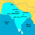
A Map for the Ajuran Sultanate edit
-
The map should be identical to the map from historyfiles.co.uk
-
[[1]] (if needed)
-
Description of third image (if needed; don't request too many at once, though)
Ajuran Sultanate: [[]]
- Request
- (details of your request go here...) --Karamumkaram (talk) 14:02, 7 April 2024 (UTC) The map needs to be based on the one from [[7]]
- Graphist opinion(s)
A Map for the Ajuran Sultanate edit
-
Description of first image
-
Description of second image (if needed)
-
Description of third image (if needed; don't request too many at once, though)
Ajuran Sultanate: [[]]
- Request
- (details of your request go here...) --Karamumkaram (talk) 14:04, 7 April 2024 (UTC) The map needs to be based on the one from [[8]]
- Graphist opinion(s)
Fixing arrowheads in an SVG map edit
-
 Map of the Ottoman Empire in 1590

Article(s): en:Empire of the Sultans, a Featured Article Candidate
- Request
- This is a valid SVG file edited in Inkscape but saved as plain SVG. When I look at this file in Inkscape or in a web browser, the arrowheads are pointing in the correct direction. When viewed on Wikimedia, the arrowheads all point to the right. Any help is gratefully received for getting the arrows to render properly on Wikimedia. --MartinPoulter (talk) 16:18, 11 April 2024 (UTC)
I've updated this to a version without arrowheads. The previous version had the arrowhead problem: I still welcome advice on how I can put arrows into diagrams in Inkscape and have the arrowheads render properly on Wikimedia. MartinPoulter (talk) 15:29, 12 April 2024 (UTC)
- Graphist opinion(s)