File:Benghazi Conflict Detailed Map.svg

Size of this PNG preview of this SVG file: 712 × 600 pixels. Other resolutions: 285 × 240 pixels | 570 × 480 pixels | 912 × 768 pixels | 1,215 × 1,024 pixels | 2,431 × 2,048 pixels | 978 × 824 pixels.
Original file (SVG file, nominally 978 × 824 pixels, file size: 3.24 MB)
Captions
Captions
Add a one-line explanation of what this file represents
Summary edit
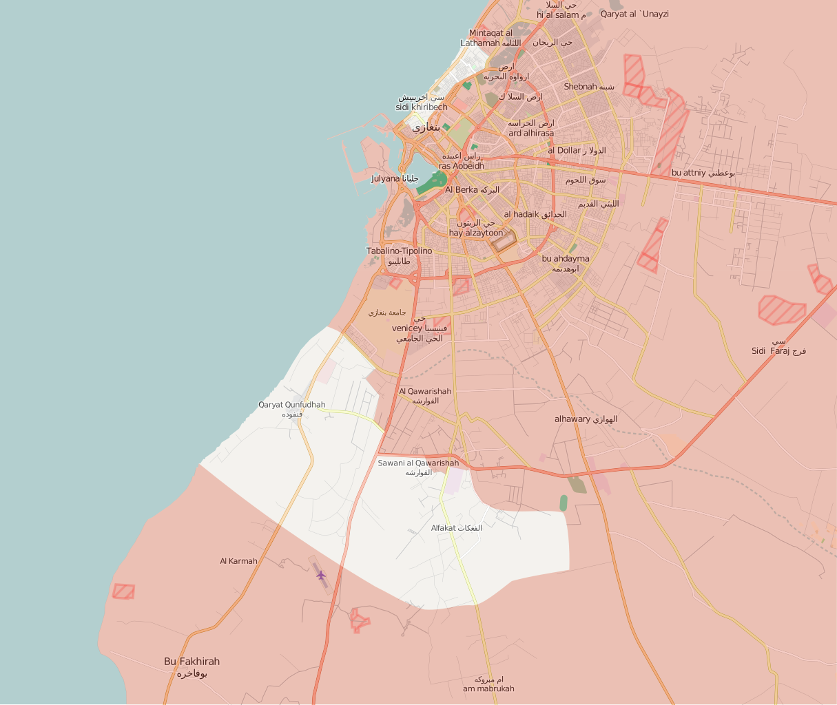
| Description |
Deutsch:
Unter Kontrolle des Abgeordnetenrats in Tobruk und Verbündeten
Kontrolliert durch Revolutionärer Schura-Rat von Bengasi English:
Under the control of the Tobruk-led Government and Libyan National Army
Controlled by the Shura Council of Benghazi Revolutionaries Italiano:
Sotto il controllo del Governo di Tobruk e Alleati
Controllato dallo Consiglio consultivo dei rivoluzionari di Bengasi |
||||
| Date | |||||
| Source | Own work, after the map from PutItOnAMap, basic map from http://www.openstreetmap.org. | ||||
| Author | Ermanarich | ||||
| Other versions |
|


.svg)

.png)


.svg)


.svg)


_Territory_Change_2014-2016.gif)

_(within_Northern_Syria).svg)


.png)
.svg)


_map.png)
.svg)


.svg)


Licensing edit
I, the copyright holder of this work, hereby publish it under the following license:
This file is licensed under the Creative Commons Attribution-Share Alike 4.0 International license.
- You are free:
- to share – to copy, distribute and transmit the work
- to remix – to adapt the work
- Under the following conditions:
- attribution – You must give appropriate credit, provide a link to the license, and indicate if changes were made. You may do so in any reasonable manner, but not in any way that suggests the licensor endorses you or your use.
- share alike – If you remix, transform, or build upon the material, you must distribute your contributions under the same or compatible license as the original.
File history
Click on a date/time to view the file as it appeared at that time.
| Date/Time | Thumbnail | Dimensions | User | Comment | |
|---|---|---|---|---|---|
| current | 17:14, 4 January 2018 | | 978 × 824 (3.24 MB) | MonsterHunter32 (talk | contribs) | Reverted to version as of 23:43, 22 August 2016 (UTC) so that the readers can see the situation when the battle was occuring. |
| 15:00, 10 November 2017 |  | 1,044 × 879 (3.21 MB) | Kami888 (talk | contribs) | Revert - turns out Sidi Akribesh was never captured after all | |
| 12:15, 10 July 2017 |  | 1,044 × 879 (3.21 MB) | Kami888 (talk | contribs) | LNA claims last militants are defeated, the battle is over. https://www.libyaherald.com/2017/07/09/breaking-lna-says-tonight-it-has-taken-last-benghazi-militant-positions/ | |
| 04:06, 7 July 2017 |  | 1,044 × 879 (3.21 MB) | Kami888 (talk | contribs) | Hospital, hotel, and most of the Sabri district is claimed by LNA. Last militants are holding out in Sidi Akribesh. https://www.libyaherald.com/2017/07/05/breaking-lna-says-benghazis-sabri-has-all-but-fallen/ https://www.libyaherald.com/2017/07/06/lead... | |
| 03:01, 25 June 2017 |  | 1,044 × 879 (3.21 MB) | Kami888 (talk | contribs) | suddenly... souq al hout and eastern sabri reportedly taken as militants flee. Clashes at Sharif Street in the west and at wahda (sabri branch) bank in the east. https://www.libyaherald.com/2017/06/23/benghazis-suq-al-hout-finally-taken-says-lna-heavin... | |
| 00:20, 22 June 2017 |  | 1,044 × 879 (3.21 MB) | Kami888 (talk | contribs) | Fish market (Souk al Hout), Erkheis mosque, and much of the Al-Ageeb street is captured. Using a relatively conservative estimate since the capture of the Christian churches has not been reported. https://www.libyaherald.com/2017/06/19/lna-says-it-has-... | |
| 06:40, 19 June 2017 |  | 1,044 × 879 (3.21 MB) | Kami888 (talk | contribs) | wahda bank & misrata street in souq-al-hout to red https://www.libyaherald.com/2017/06/16/five-lna-soldiers-killed-in-suq-al-hout-offensive/ | |
| 01:21, 15 June 2017 |  | 1,044 × 879 (3.21 MB) | Kami888 (talk | contribs) | Tahrir square and courthouse captured https://www.libyaherald.com/2017/06/13/benghazis-iconic-tahrir-square-taken-by-lna-as-suq-al-hout-hit-by-airstrikes/ | |
| 08:51, 13 June 2017 |  | 1,044 × 879 (3.21 MB) | Kami888 (talk | contribs) | Adjusted frontlines based on multiple sources linked in talk page. Also added an unclear area where I just can't figure out what is happening. In line with the similar maps that area is marked in #8080007b. This change does not represent SCBR advance. | |
| 01:25, 23 March 2017 |  | 1,044 × 879 (3.24 MB) | Kami888 (talk | contribs) | https://www.libyaherald.com/2017/03/18/breaking-ganfouda-12-apartments-complex-finally-taken/ |
You cannot overwrite this file.
File usage on Commons
More than 100 pages use this file. The following list shows the first 100 pages that use this file only. A full list is available.
- User:Hermes79
- User:Hermes7979
- User:Magog the Ogre/Maps of conflicts/2016 August
- User:Magog the Ogre/Maps of conflicts/2017 February
- User:Magog the Ogre/Maps of conflicts/2017 July
- User:Magog the Ogre/Maps of conflicts/2017 June
- User:Magog the Ogre/Maps of conflicts/2017 March
- User:Magog the Ogre/Maps of conflicts/2017 November
- User:Magog the Ogre/Maps of conflicts/2018 January
- File:2013 Hama Offensive.svg
- File:2015 Latakia Frontlines.svg
- File:Aleppo Offensives 2015.svg
- File:Aleppo offensive (October 2013).svg
- File:Attaques-terroristes-meurtrières-au-21eme-siecle.png
- File:Battle of Daraa City.svg
- File:Battle of Hasakah.svg
- File:Battle of Qamishli.svg
- File:Battle of Raqqa.svg
- File:Battle of Tadmur.svg
- File:Battle of Western Qalamoun.svg
- File:Battlefields in The Global War on Terror.svg
- File:Battlefields in The Global War on Terror - edit03.png
- File:Battlefields in The Global War on Terror - edit04.png
- File:Benghazi Août 2016.svg (file redirect)
- File:Benghazi Conflict Detailed Map.png
- File:Benghazi Conflict Detailed Map.svg
- File:Boko Haram insurgency map.svg
- File:Countries by soldier count.svg
- File:Daraa 2018 gif.gif
- File:Deir ez-Zor clashes (2017).svg
- File:Derna Conflict Detailed Map.png
- File:East Congo conflict map.svg
- File:GSPC map.png
- File:ISIS (Grey) Territory Change 2014-2016.gif
- File:Iraqi Civil War map (2014–present).png
- File:Iraqi–Kurdish conflict map.png
- File:Islamist insurgency in Nigeria.svg
- File:Lebanese insurgency.svg
- File:Libyan Civil War.svg
- File:Libyan war final-fr.svg
- File:Map of Ongoing conflicts around the world.png
- File:Map of terror of the Islamic State (ad-Daula al-islāmiyya).png
- File:Mexico states map small war.PNG
- File:Mosul offensive (2015) map.png
- File:Number of Terrorist Incidents.png
- File:Ongoing Conflicts (1).png
- File:Pakistan-Waziristan-Map.png
- File:Political map Afar triangle.png
- File:Rif Damashq.svg
- File:Siege of Homs Map.svg
- File:Sinai insurgency.svg
- File:Sinai map.PNG
- File:Somali Civil War (2009-present).svg
- File:Syria and Iraq 2014-onward War map.png
- File:Syrian, Iraqi, and Lebanese insurgencies.png
- File:Syrian Civil War map.svg
- File:Syrian civil war.png
- File:Tadmur offensive (2015).jpg
- File:Turkish attack on Efrin.svg
- File:Yemeni Civil War.svg
- Template:City maps of ongoing civil wars
- Category:Aleppo
- Category:Attack
- Category:Battle of Aleppo
- Category:Battles in 2016
- Category:Battles in 2022
- Category:Battles in 2023
- Category:Battles of Syria
- Category:Battles of the Syrian Civil War
- Category:Cities in Syria
- Category:Civil wars
- Category:Conflicts
- Category:Conflicts by continent
- Category:Conflicts by country
- Category:Conflicts by type
- Category:Feuds
- Category:Fights
- Category:Liberation of Palmyra (2016)
- Category:Maps of Aleppo
- Category:Maps of Somali Civil War
- Category:Maps of conflicts
- Category:Maps of disputed territories
- Category:Maps of the Syrian Civil War in 2016
- Category:Maps of the Syrian Civil War in 2017
- Category:Maps of the Syrian Civil War in 2018
- Category:Maps of the Syrian Civil War in 2019
- Category:Maps of the Syrian Civil War in 2020
- Category:Maps of the Syrian Civil War in 2021
- Category:Maps of the Syrian Civil War in 2022
- Category:Military conflicts
- Category:Ongoing armed conflicts
- Category:Palmyra offensive (December 2016)
- Category:Quarrels
- Category:Rebellions
- Category:Riots
- Category:Schisms
- Category:Syrian Civil War
- Category:Terrorism
- Category:Uprisings
- Category:War casualties
.svg)
.png)
.png)
.jpg)
View more links to this file.
File usage on other wikis
The following other wikis use this file:
- Usage on ar.wikipedia.org
- Usage on be.wikipedia.org
- Usage on en.wikipedia.org
- Usage on es.wikipedia.org
- Usage on fa.wikipedia.org
- Usage on fr.wikipedia.org
- Usage on pt.wikipedia.org
- Usage on ru.wikipedia.org
- Usage on www.wikidata.org