File:USA NY Thruway Schematic Diagram.svg

Original file (SVG file, nominally 2,200 × 500 pixels, file size: 28 KB)
Captions
Captions
Summary edit
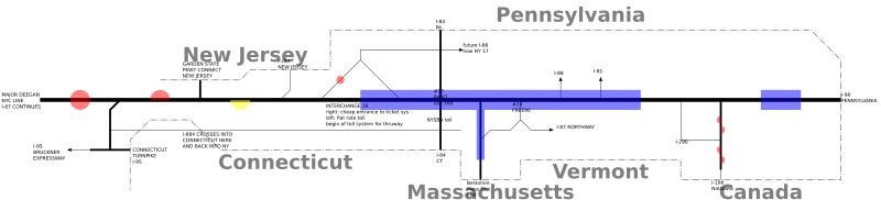
I made this using Inkscape. I used New York State Thruway#Interchanges and toll barriers for most source information; I might have glanced at a map once or twice. Legend:
- Thickest black line is the mainline thruway, going from NYC (left) to PA (right)
- thicker black lines are other thruway parts
- other black lines are certain interstate highways not in the thruway. Not every one is there; only those with a special significance in the thruway sytem (for instance, i-90 can be used to shunpike easily)
- circles and semicircles are flat tolls; red means all vehicles must pay; yellow means just commercial traffic; a circle means both directions; a semicircle means just the side that it's on
- the blue rectangles denote ticket system areas; any roads crossing the edges must get a ticket or pay toll. the only exception here is i-84; if you stay on i-84; there is no toll, but if you get off exit 7 and onto the thruway there is
I'm well aware that the labels suck. I'm going to fix those later (will have interstate shields and everything like that).
This is intentionally not to scale. I will label every 100th mile marker in the next revision to show some sence of scale (You'll notice that about half of my diagram covers just the first 100 miles; this is simply because much more happens to the Thruway in the w:New York City vicinity.) The shown features of the mainline are spaced 100 pixels apart; those on all other roads are generally 50 pixels apart (more will be there if there is an interchange with another road that is further than 50 pixels away), with the exception if w:I-190 (NY), which has everything 25 pixels apart.
Interchange 16 needs much much more explanation; it takes up 3 points on the 100-pixel scale of the mainline, and has two fictional roads traveling west and merging to make w:I-86 (E). Please note that this is not at all how the interchange looks from overhead, and the way it works schematically is not at all evident looking from overhead.
All freeways under NYSTA are shown in their entirety. All intersections with 2dis are shown. If ANY Interstate highway provides a link between two parts of the Thruway, they are also shown (w:I-684,w:I-290 (NY),w:Free 90); also any Interstate highway that remains in New York state after it leaves NYSTA juristiction (aside from the mainline) is shown (I-190 (NY), I-95).
Changelog edit
I made this since there's too many changes to be listed in the revision summarry.
2005-12-09 edit
- Removed some unnecessary arrows (in all cases where there are no more Interstate junctions within NY):
- 190
- 287
- 684
- Drew state lines and names
PNG only edit
Added shields all along each 2di.
2005-11-19 edit
Initial public release
Licensing edit

|
Permission is granted to copy, distribute and/or modify this document under the terms of the GNU Free Documentation License, Version 1.2 or any later version published by the Free Software Foundation; with no Invariant Sections, no Front-Cover Texts, and no Back-Cover Texts. A copy of the license is included in the section entitled GNU Free Documentation License. |
| This file is licensed under the Creative Commons Attribution-Share Alike 3.0 Unported license. | ||
| ||
| This licensing tag was added to this file as part of the GFDL licensing update. |
- You are free:
- to share – to copy, distribute and transmit the work
- to remix – to adapt the work
- Under the following conditions:
- attribution – You must give appropriate credit, provide a link to the license, and indicate if changes were made. You may do so in any reasonable manner, but not in any way that suggests the licensor endorses you or your use.
- share alike – If you remix, transform, or build upon the material, you must distribute your contributions under the same or compatible license as the original.
File history
Click on a date/time to view the file as it appeared at that time.
| Date/Time | Thumbnail | Dimensions | User | Comment | |
|---|---|---|---|---|---|
| current | 13:32, 9 December 2005 | 2,200 × 500 (28 KB) | Engleman~commonswiki (talk | contribs) | See Image:USA NY Thruway Schematic Diagram.svg#Change Log | |
| 00:01, 20 November 2005 | 2,200 × 500 (24 KB) | Engleman~commonswiki (talk | contribs) | I made this using Inkscape. I used w:New York State Thruway#Interchanges and toll barriers for most source information; I might have glanced at a map once or twice. Legend: -Thickest black line is the mainline thruway, going from NYC (left) to PA (rig |
You cannot overwrite this file.
File usage on Commons
There are no pages that use this file.
File usage on other wikis
The following other wikis use this file:
- Usage on en.wikipedia.org