File:British Isles (orthographic projection).svg
Jump to navigation
Jump to search

Size of this PNG preview of this SVG file: 550 × 550 pixels. Other resolutions: 240 × 240 pixels | 480 × 480 pixels | 768 × 768 pixels | 1,024 × 1,024 pixels | 2,048 × 2,048 pixels.
Original file (SVG file, nominally 550 × 550 pixels, file size: 658 KB)
Captions
Captions
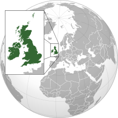
British Isles (orthographic projection)
Summary[edit]
.svg&action=edit§ion=1)
| Description |
English: Orthographic projection of the British Isles, with national borders. |
| Date | |
| Source |
Derived from: |
| Author | Rob |
| SVG development |
.svg)
Licensing[edit]
.svg&action=edit§ion=2)
I, the copyright holder of this work, hereby publish it under the following license:
This file is licensed under the Creative Commons Attribution-Share Alike 3.0 Unported license.
- You are free:
- to share – to copy, distribute and transmit the work
- to remix – to adapt the work
- Under the following conditions:
- attribution – You must give appropriate credit, provide a link to the license, and indicate if changes were made. You may do so in any reasonable manner, but not in any way that suggests the licensor endorses you or your use.
- share alike – If you remix, transform, or build upon the material, you must distribute your contributions under the same or compatible license as the original.
File history
Click on a date/time to view the file as it appeared at that time.
| Date/Time | Thumbnail | Dimensions | User | Comment | |
|---|---|---|---|---|---|
| current | 15:28, 9 March 2014 | | 550 × 550 (658 KB) | Rob984 (talk | contribs) | Correct UK-Ireland border |
| 14:56, 9 March 2014 |  | 550 × 550 (665 KB) | Rob984 (talk | contribs) | User created page with UploadWizard |
You cannot overwrite this file.
File usage on Commons
More than 100 pages use this file. The following list shows the first 100 pages that use this file only. A full list is available.
.svg)
- Atlas of the United Kingdom
- British Isles
- Grey–green orthographic projections maps
- User:Heraldry/Projections
- User:Ssolbergj/orthographic
- File:ALBA (orthographic projection).png
- File:Africa (orthographic projection).svg
- File:African Union (orthographic projection).svg
- File:Almoravid map.svg
- File:America do Sul (orthographic projection).jpg
- File:Americas (orthographic projection).svg
- File:Andean Community (orthographic projection).svg
- File:Antarctica (orthographic projection).svg
- File:Antillas (orthographic projection).svg
- File:Arctic (orthographic projection).svg
- File:Argentina (orthographic projection).png
- File:Argentina (orthographic projection).svg
- File:Aridoamerica (orthographic projection).svg
- File:Armenia (orthographic projection).svg
- File:Asia (orthographic projection).svg
- File:Association of Southeast Asian Nations (orthographic projection).svg
- File:Australia-New Guinea (orthographic projection).svg
- File:Australia (orthographic projection).svg
- File:Australia map with outlying islands.svg
- File:Bhutan (orthographic projection).svg
- File:Brazil (orthographic projection).svg
- File:CECAFA-Map.svg
- File:Canada (orthographic projection).svg
- File:Cape Verde (orthographic projection).svg
- File:Central America (orthographic projection).svg
- File:Central Asia (orthographic projection).svg
- File:Chile (orthographic projection).svg
- File:Colombia (orthographic projection).svg
- File:Democratic Republic of the Congo (orthographic projection).svg
- File:Dominion of Pakistan & Indian Controlled Kashmir (orthographic projection).svg
- File:East Asia (orthographic projection).svg
- File:Ecuador (orthographic projection).svg
- File:Europe (orthographic projection).svg
- File:European Union (orthographic projection).svg
- File:Federal Republic of Central America (orthographic projection).svg
- File:First Brazilian Empire (orthographic projection).svg
- File:First Mexican Empire (orthographic projection).svg
- File:Georgia (orthographic projection).svg
- File:Germany (orthographic projection).svg
- File:Global European Union.svg
- File:Great Colombia (orthographic projection).svg
- File:Greater Middle East (orthographic projection).svg
- File:Haiti (orthographic projection).svg
- File:India (orthographic projection).svg
- File:Indonesia (orthographic projection).svg
- File:Iran (orthographic projection).svg
- File:Iraq (orthographic projection).svg
- File:Jamaica (orthographic projection).svg
- File:Japan (orthographic projection).svg
- File:Kazakhstan (orthographic projection).svg
- File:Latin America (orthographic projection).svg
- File:Lusophone America (orthographic projection).svg
- File:MERCOSUR (orthographic projection).svg
- File:Madagascar (orthographic projection).svg
- File:Maghreb (orthographic projection).svg
- File:Malaysia (orthographic projection).svg
- File:Mayan languages (orthographic projection).svg
- File:Mesoamerica (orthographic projection) with borders.svg
- File:Mexico (orthographic projection).svg
- File:Mexico and Central America (orthographic projection).svg
- File:Middle East (orthographic projection).svg
- File:Mongolia (orthographic projection).svg
- File:New Spain (orthographic projection).svg
- File:New Zealand (orthographic projection).svg
- File:Nigeria (orthographic projection).svg
- File:North Africa (orthographic projection).svg
- File:North America (orthographic projection).svg
- File:North American Agreement (orthographic projection).svg
- File:North Korea (orthographic projection).svg
- File:Papua New Guinea (orthographic projection).svg
- File:Paraguay (orthographic projection).svg
- File:People's Republic of China (orthographic projection).svg
- File:Peru (orthographic projection).svg
- File:Peru–Bolivia Confederation (orthographic projection).svg
- File:Philippines (orthographic projection).svg
- File:Republic of Artsakh (orthographic projection).svg
- File:Republic of China (orthographic projection).svg
- File:Rio Group (orthographic projection).svg
- File:Roman Empire (orthographic projection).svg
- File:Russian Federation (orthographic projection).svg
- File:Second Mexican Empire (orthographic projection).svg
- File:South Asia (orthographic projection) without national boundaries.svg
- File:South Korea (orthographic projection).svg
- File:Southern Europe (orthographic projection).svg
- File:Tawantinsuyu (orthographic projection).svg
- File:The Philippines and ASEAN (orthographic projection).svg
- File:Third Reich (orthographic projection).svg
- File:Tunisia (orthographic projection).svg
- File:Turkey (orthographic projection).svg
- File:Union of South American Nations (orthographic projection).svg
- File:Union of Soviet Socialist Republics (orthographic projection).svg
- File:United Provinces of Central America (orthographic projection).svg
- File:Venezuela (orthographic projection).svg
- File:Viceroyalty of Peru (orthographic projection).svg
- File:Viceroyalty of the Río de la Plata (orthographic projection).svg
.png)
.svg)
.svg)
.jpg)
.svg)
.svg)
.svg)
.svg)
.svg)
.png)
.svg)
.svg)
.svg)
.svg)
.svg)
.svg)
.svg)
.svg)
.svg)
.svg)
.svg)
.svg)
.svg)
.svg)
.svg)
.svg)
.svg)
.svg)
.svg)
.svg)
.svg)
.svg)
.svg)
.svg)
.svg)
.svg)
.svg)
.svg)
.svg)
.svg)
.svg)
.svg)
.svg)
.svg)
.svg)
.svg)
.svg)
.svg)
.svg)
.svg)
.svg)
.svg)
.svg)
_with_borders.svg)
.svg)
.svg)
.svg)
.svg)
.svg)
.svg)
.svg)
.svg)
.svg)
.svg)
.svg)
.svg)
.svg)
.svg)
.svg)
.svg)
.svg)
.svg)
.svg)
.svg)
.svg)
.svg)
.svg)
_without_national_boundaries.svg)
.svg)
.svg)
.svg)
.svg)
.svg)
.svg)
.svg)
.svg)
.svg)
.svg)
.svg)
.svg)
.svg)
View more links to this file.
File usage on other wikis
The following other wikis use this file:
- Usage on ar.wikipedia.org
- Usage on bn.wikipedia.org
- Usage on de.wikipedia.org
- Usage on en.wikipedia.org
- Usage on et.wikipedia.org
- Usage on fa.wikipedia.org
- Usage on fr.wiktionary.org
- Usage on ja.wikipedia.org
- Usage on ru.wikipedia.org
- Usage on ru.wiktionary.org
- Usage on simple.wikipedia.org
- Usage on vi.wikipedia.org
.svg&oldid=834307127)