File:Morocco Protectorate.svg
Jump to navigation
Jump to search

Size of this PNG preview of this SVG file: 406 × 388 pixels. Other resolutions: 251 × 240 pixels | 502 × 480 pixels | 804 × 768 pixels | 1,072 × 1,024 pixels | 2,143 × 2,048 pixels.
Original file (SVG file, nominally 406 × 388 pixels, file size: 815 KB)
Captions
Captions
Add a one-line explanation of what this file represents
Summary[edit]
| Description |
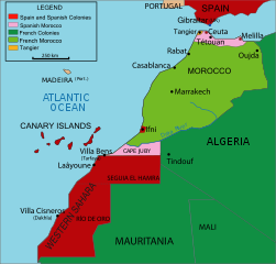
English: Vectorised map about the French and Spanish protectorate on Morocco in 1912 - own work inspired from Jean Sellier, Atlas des peuples d'Afrique, p. 84. Français : Protectorat marocain Español: Protectorado marroquí
A PNG french version is available |
||||||||
| Source | Image:Maroc sans cadre.svg | ||||||||
| Author | Cradel | ||||||||
| Permission (Reusing this file) |
I, the copyright holder of this work, hereby publish it under the following licenses:
This file is licensed under the Creative Commons Attribution-Share Alike 2.5 Generic, 2.0 Generic and 1.0 Generic license.
You may select the license of your choice. |
||||||||
| Other versions |
|
||||||||
| SVG development |


File history
Click on a date/time to view the file as it appeared at that time.
| Date/Time | Thumbnail | Dimensions | User | Comment | |
|---|---|---|---|---|---|
| current | 19:25, 16 November 2020 | | 406 × 388 (815 KB) | Fertejol (talk | contribs) | Reverted to version as of 13:49, 4 June 2008 (UTC) The legal international status of Cap Juby zone never changed during the Spanish ocupation (1912-1958). |
| 00:05, 28 March 2010 |  | 406 × 388 (827 KB) | Flad (talk | contribs) | Position adjustment. | |
| 23:51, 27 March 2010 |  | 406 × 388 (828 KB) | Flad (talk | contribs) | Transform some text in order to show properly. | |
| 23:49, 27 March 2010 |  | 406 × 388 (825 KB) | Flad (talk | contribs) | Transform some text in order to show properly. | |
| 23:46, 27 March 2010 |  | 406 × 388 (825 KB) | Flad (talk | contribs) | Cap Juby was considered as a part of the spanish colonies. Transform some text to show properly. | |
| 13:49, 4 June 2008 |  | 406 × 388 (815 KB) | Cradel (talk | contribs) | more translating Category:Images by Cradel | |
| 19:38, 1 June 2008 |  | 406 × 388 (817 KB) | Cradel (talk | contribs) | Cape Juby | |
| 09:01, 1 June 2008 |  | 406 × 388 (821 KB) | Cradel (talk | contribs) | {{Information |Description={{en|1=Vectorised map about thefrench and spanish protectorate on marocco In 1912 own work inspired from Jean Sellier, Atlas des peuples d'Afrique,p 84. Protectorat marocain Protectorado maroqui A PNG french version is availabl |
You cannot overwrite this file.
File usage on Commons
The following 8 pages use this file:
.png)
.svg)
File usage on other wikis
The following other wikis use this file:
- Usage on ary.wikipedia.org
- Usage on ast.wikipedia.org
- Usage on azb.wikipedia.org
- Usage on be.wikipedia.org
- Usage on cs.wikipedia.org
- Usage on da.wikipedia.org
- Usage on en.wikipedia.org
- Usage on eo.wikipedia.org
- Usage on eu.wikipedia.org
- Usage on fa.wikipedia.org
- Usage on fi.wikipedia.org
- Usage on gl.wikipedia.org
- Usage on he.wikipedia.org
- Usage on hr.wikipedia.org
- Usage on id.wikipedia.org
- Usage on io.wikipedia.org
- Usage on it.wikipedia.org
- Usage on ja.wikipedia.org
View more global usage of this file.