By Richard C. Malley
Beginning in the mid-1930s, state and federal governments examined ways to improve road transportation around the country. While some federal roads linked major population centers, most areas still struggled with a variety of state, county, and town roads, ranging in condition from decent to abominable. In the years leading up to World War II, the federal government looked for ways to improve transportation in the event the United States went to war.
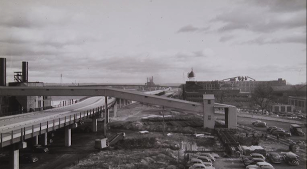
War broke out before workers accomplished much in Hartford, but by 1945 a multilane elevated road called the “Dike Highway” reached completion along the city’s waterfront, followed in 1948 by the North Meadows Highway running north of the intersection with the Bulkeley Bridge. These projects presaged the ultimate construction of I-91, part of the interstate highway system authorized by the 1956 National Interstate and Defense Highways Act.
One of the east-west components of the interstate highway legislation was I-84, roughly following the line of Route 6 across the state toward Providence, Rhode Island (though ultimately redirected northeast to join the Massachusetts Turnpike). Whereas I-91 skirted the eastern edge of Hartford, I-84 carved a swath out of the city’s downtown, creating a physical—as well as ethnic, racial, and economic—divide. The road bisected or eliminated entire neighborhoods. Photographers and artists, including Richard Welling, documented these new highways’ effects on the city.
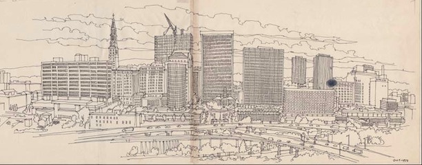
Hartford from East Hartford. Drawing by Richard Welling, 1973. I-91 redefined Hartford’s east side, effectively cutting it off from the Connecticut River – Connecticut Historical Society, gift of the Richard Welling family
The building of I-84 and I-91 may have increased interstate transportation, but it created problems that endure to the present day, and city planners and special interest groups continue to grapple with the legacy of these projects. Beginning in the 1980s, Riverfront Recapture worked hard to restore Hartford’s connection to the river, and recent plans for development in the north end (focused on a new minor league baseball stadium) provide the potential to revitalize that blighted and neglected neighborhood.
The Connecticut Historical Society has a large collection of photographs and drawings related to Hartford-area road construction and urban renewal projects which may be viewed by visiting the Waterman Research Center at One Elizabeth Street, Hartford, Connecticut.
Richard Malley was the Head of Collections at the Connecticut Historical Society.
© Connecticut Public Broadcasting Network and Connecticut Historical Society. All rights reserved. This article originally appeared on Connecticut History | WNPR News