
Original file (SVG file, nominally 922 × 762 pixels, file size: 3.56 MB)
| This is a file from the Wikimedia Commons. Information from its description page there is shown below. Commons is a freely licensed media file repository. You can help. |
Summary

|
This file may be updated to reflect new information. If you wish to use a specific version of the file without new updates being mirrored, please upload the required version as a separate file. |
| Description |
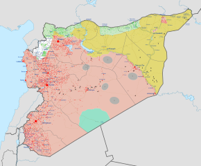
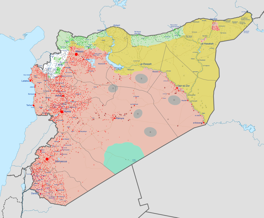
English: Map of the Syrian Civil War. Español: Mapa de la Guerra civil siria
Information to readers: Click on the image to make marks and icons visible, which are otherwise too small. To zoom into the image after you opened it, hold ctrl and scroll in/out with your mouse. To view the image in full quality, open it in Media Viewer, download the original file and open it with Inkscape (free drawing program). If you want to see the history of the Syrian Civil War before August 2016, look at Syrian civil war.png.
|
||||
| Map legend |
Bahasa Indonesia: Dikuasai oleh Angkatan Bersenjata Suriah
Dikuasai oleh Angkatan Kurdi
Dikuasai oleh Negara Islam Irak dan Syam
Wilayah dipertentangkan
Dikuasai oleh Angkatan Oposisi Bân-lâm-gú: Kok sè-le̍k saⁿ-cheⁿ ê chiân-sòaⁿ
Bosanski: Pod kontrolom Vladinih snaga
Pod kontrolom Kurda
Pod kontrolom ISIL-a
Linija između suprotstavljenih snaga
Pod kontrolom Opozicije i pobunjenika Català: Controlat pel govern
Controlat pels kurds
Controlat per l'Estat Islàmic
Controlat per forces rebels
Controlat per Tahrir al-Xam
Zones disputades Čeština: Pod kontrolou syrské vlády
Pod kontrolou syrské opozice
Pod kontrolou syrských Kurdů
Pod kontrolou Islámského státu
Pod kontrolou Fronty an-Nusrá
Sporná hranice mezi válčícími stranami Dansk: Kontrolleret af pro-Assad-styrker
Kontrolleret af syriske kurdere
Kontrolleret af Islamisk Stat (Daesh / IS / ISIL)
Omstridt område
Kontrolleret af den Syriske Nationale Koalition (den syriske opposition)
Kontrolleret af Al-Nusra-Fronten Deutsch: Umkämpftes Gebiet
English:
Español:
Euskara: Al Assaden gobernuaren kontrolpean
Kurduen kontrolpean
Estatu Islamikoaren kontrolpean
Assaden aurkako matxinoek kontrolpean
Al-Nusra frontearen kontrolpean
Indarren arteko borroka fronteak Français : Fronts
Hrvatski: Pod kontrolom Assadovih snaga
Pod kontolom Kurda
Pod kontrolom ISIL-a
Linija između suprotstavljenih snaga
Pod kontrolom protuvladinih snaga Italiano:
Linea di frontiera contesa tra le forze
Magyar: A szíriai hadsereg ellenőrzése alatt
A szíriai kurdok ellenőrzése alatt
Az Iszlám Állam ellenőrzése alatt
A szíriai ellenzéki erők koalíciójának ellenőrzése alatt
Az Al-Nuszra Front ellenőrzése alatt
Vitatott ellenőrzésű terület Nederlands: In handen van de Syrische overheid
In handen van Koerdische troepen (Rojava)
In handen van de Islamitische Staat (in Irak en de Levant) (ISIS)
Betwist gebied
Gecontroleerd door anti-Assad strijders Polski: Tereny kontrolowane przez Siły Zbrojne Syrii
Tereny kontrolowane przez Powszechne Jednostki Ochrony (siły Kurdów)
Tereny kontrolowane przez Państwo Islamskie
Tereny kontrolowane przez Syryjską Koalicję Narodową na rzecz Opozycji i Sił Rewolucyjnych
Tereny kontrolowane przez Dżabhat an-Nusra
Tereny sporne
Português: Zonas controladas por forças pro-Assad
Zonas controladas por forças curdas
Zonas controladas pelo Estado Islâmico
Zonas em disputa
Zonas controladas por outras forças anti-Assad Română: Zone controlate de forțele pro-Assad
Zone controlate de forțele kurde
Zone controlate de forțele Statului Islamic
Zone disputate
Zone controlate de forțele anti-Assad Shqip: E kontrolluar nga forcat e Assadit
E kontrolluar nga forcat Kurde
E knontrolluar nga Shteti Islamik i Irakut dhe Levantit
E kontrolluar nga rebelet anti-Assad Slovenščina: Pod nadzorom sirijske vlade
Pod nadzorom sirijske opozicije
Pod nadzorom sirijskih Kurdov
Pod nadzorom Islamske države
Pod nadzorom al-Nusre
Sporno območje med več stranmi Tiếng Việt: Kiểm soát bởi lực lượng thân Assad
Kiểm soát bởi lực lượng người Kurd
Kiểm soát bởi lực lượng chống Assad Türkçe:
Ελληνικά: Περιοχή ελεγχόμενη από τον κυβερνητικό Στρατό της Συρίας
Περιοχή ελεγχόμενη από το Μέτωπο αλ Νούσρα
Περιοχή ελεγχόμενη από την Συριακή Προσωρινή Κυβέρνηση (SNA και συμμάχους)
Περιοχή ελεγχόμενη από τις κουρδικές Μονάδες Λαϊκής Προστασίας
Περιοχή ελεγχόμενη από το Ισλαμικό Κράτος
Περιοχή ελεγχόμενη από τον Συριακό Εθνικό Συνασπισμό (συριακή αντιπολίτευση)
Η διαφιλονικούμενη γραμμή του μετώπου ανάμεσα σε αντίπαλες δυνάμεις Беларуская (тарашкевіца): Пад кантролем урада Асада
Пад кантролем курдскіх сілаў
Пад кантролем Ісламскай Дзяржавы (ІДІЛ)
Спрэчныя тэрыторыі
Пад кантролем апазыцыі Български: Под контрол на правителствените сили
Под контрол на кюрдските милиции
Под контрол на ИДИЛ
Оспорвани земи
Под контрол на бунтовниците Русский:
Спорная территория между воюющими сторонами
Српски (ћирилица): Под контролом Асадових снага
Под контролом Курда
Под контролом Исламске Државе
Линија између супрострављених снага
Под контролом побуњеничких снага Українська: Під контролем уряду Асада
Під контролем курдських сил
Під контролем Ісламської Держави (ІДІЛ)
Спірні території
Під контролем опозиції ქართული: კონტროლირდება სირიის მთავრობის მიერ
კონტროლირდება სირიელი ქურთების მიერ
კონტროლირდება დაეშ-ის მიერ
საკამათო ტერიტორია
კონტროლირდება სირიის ოპოზიციის მიერ Հայերեն : Վերահսկվում է Սիրիական կառավարական ուժերի կողմից
Վերահսկվում է քրդերի կողմից
Վերահսկվում է ընդդիմադիր ուժերի կողմից
Վերահսկվում է "ան-Նուսրա" խմբավորման կողմից
Վերահսկվում է "Իրաքի և Լևանտի իսլամական պետության" կողմից
Հակամարտող կոմղերի միջև վիճելի տարածքներ संस्कृतम् : असदसमर्थक सेनानाम् नियन्त्रणे क्षेत्राः
कुर्द सेनानाम् नियन्त्रणे क्षेत्राः
ISIS सेनानाम् नियन्त्रणे क्षेत्राः
सेनानाम् मध्ये विवदित क्षेत्राः
असदविरोधी सेनानाम् नियन्त्रणे क्षेत्राः 한국어: 정부군 점령 지역
쿠르드족 점령 지역
ISIS 점령 지역
양 세력 간 전선 지역
반정부군 점령 지역 中文: 巴沙尔·阿萨德政权控制的区域
库尔德人控制的区域
伊斯兰国(ISIS)控制的区域
争夺中的区域
其他反巴沙尔政权的武装控制的区域 עברית : בשליטת כוחות נאמני אסד
בשליטת כוחות כורדים
בשליטת כוחות דאע"ש
איזור במחלוקת בין הכוחות
בשליטת כוחות מתנגדי אסד العربية : القوات الحكومية
القوات الكردية
قوات داعش
مناطق مواجهات غير محسومة
قوات المعارضة تۆرکجه : سوریه حکومتی سیلاحلی گوجلری
عراق و شام ایسلام دؤلتی
سوریه موخالیفلری
النوصره جبههسی
سوریه دموکراتیک گوجلری
ساواشما گئدن یادا ایختیلافلی بؤلگهلر
فارسی : در دست ارتش سوریه
در دست نیروهای کرد
در دست داعش
مناطق درگیری
در دست مخالفان اسد
در دست تحریر الشام كوردي (عەرەبی): سوپای ڕژێم
هێزه كوردیهكان
دهوڵهتی ئیسلامی له عیڕاق و شام
ئهو ناوچانهی چارهنوسیان یهكلا نهبۆتهوه
هێزهكانی ئۆپۆزسیۆن |
||||
| Date | between 2011 and 2018 | ||||
| Source |
Own work, derived from the Template:Syrian Civil War detailed map.
|
||||
| Creator | |||||
| Georeferencing | If inappropriate please set warp_status = skip to hide. | ||||
| Other versions |
|


.png)


.svg)


.svg)

.svg)


_Territory_Change_2014-2016.gif)

_(within_Northern_Syria).svg)


.png)
.svg)


_map.png)
.svg)


.svg)


Licensing
- You are free:
- to share – to copy, distribute and transmit the work
- to remix – to adapt the work
- Under the following conditions:
- attribution – You must give appropriate credit, provide a link to the license, and indicate if changes were made. You may do so in any reasonable manner, but not in any way that suggests the licensor endorses you or your use.
- share alike – If you remix, transform, or build upon the material, you must distribute your contributions under the same or compatible license as the original.
File history
Click on a date/time to view the file as it appeared at that time.
| Date/Time | Thumbnail | Dimensions | User | Comment | |
|---|---|---|---|---|---|
| 17:41, 3 February 2021 |  | 922 × 762 (10.28 MB) | Brobt | February 2021 update based on template | |
| 19:28, 25 October 2020 |  | 983 × 813 (10.78 MB) | AntiCompositeNumber | Reverted to version as of 17:26, 6 October 2020 (UTC): phab:T217990, too many elements to fix by hand | |
| 18:37, 25 October 2020 |  | 983 × 813 (4.55 MB) | HeracleitusNynniaw | Fix | |
| 18:26, 25 October 2020 |  | 983 × 813 (4.55 MB) | HeracleitusNynniaw | Cleanup | |
| 17:26, 6 October 2020 |  | 983 × 813 (10.78 MB) | Garmin21 | Reverted to version as of 06:32, 5 September 2020 (UTC) Unexplained Content revert | |
| 18:00, 4 October 2020 |  | 983 × 813 (10.8 MB) | Brobt | Reverted to version as of 15:58, 4 September 2020 (UTC) | |
| 06:32, 5 September 2020 |  | 983 × 813 (10.78 MB) | GnomonTimber | Reverted to version as of 06:05, 19 August 2020 (UTC) You don't need to give me anything. References are needed to make changes which you are yet to share for the file. Etana albeit dates 2018 is still the same see (https://en.wikipedia.org/wiki/File:Daraa_Insurgency_(2020).svg) The Russian def min map is set to show US and Russian troops boundary and it is also referenced. Discussion is taking place regarding your agreesive reverting behaviour. | |
| 15:58, 4 September 2020 |  | 983 × 813 (10.8 MB) | Brobt | I gave you the benefit of the doubt, but I took a look on a whim today and realized something. For one, the module ABSOLUTELY reflects these changes, and secondly, the sources you linked were clearly dated to 2018, not 2020. The Russian source doesn’t distinguish between Coalition and Kurds, and ETANA is literally a perfect copy of this version of the svg. | |
| 06:05, 19 August 2020 |  | 983 × 813 (10.78 MB) | GnomonTimber | Reverted to version as of 10:08, 18 August 2020 (UTC) No such "consensus" can be found at the talk page you referenced. Again South Syria reconciliation and SDF are sourced, while your recent changes are not. http://syria.mil.ru/peacemaking/infographics.htm (North) twitter.com/ETANA_Syria/status/1054388592234110977 (South) | |
| 19:13, 18 August 2020 |  | 983 × 813 (10.8 MB) | Brobt | Alright, should be fixed now. |
File usage
The following file is a duplicate of this file (more details):
- File:Syrian Civil War map (November 24, 2023).svg from Commons
.svg)
- Talk:Control of cities during the Syrian civil war/Archive 65
- Talk:Islamic State/Archive 41
- Talk:Revolutionary Commando Army
- Talk:Syrian civil war/Archive 44
- Talk:Syrian civil war/Archive 51
- User:Crewcamel/sandbox
- User:CubanoBoi/sandbox12
- User:Mhxyqwe123/sandbox
- User:PanNostraticism2/sandbox
- User:S0V3R31GNN0RT0N/sandbox
- Wikipedia:Top 25 Report/April 2 to 8, 2017
- Wikipedia:Top 25 Report/February 25 to March 3, 2018
- Wikipedia:Wikipedia Signpost/2018-03-29/Traffic report
- Wikipedia:Wikipedia Signpost/Single/2018-03-29
Global file usage
The following other wikis use this file:
- Usage on ar.wikipedia.org
- Usage on arz.wikipedia.org
- Usage on dag.wikipedia.org
- Usage on es.wikipedia.org
- Usage on fr.wikipedia.org
- Usage on he.wikipedia.org
- Usage on it.wikipedia.org
- Usage on tr.wikiquote.org
- Usage on www.wikidata.org