's-Heer Abtskerke is a village in the Dutch province of Zeeland. It is a part of the municipality of Borsele, and lies about 19 km east of Middelburg.
's-Heer Abtskerke | |
|---|---|
Village | |
.jpg) John the Baptist church | |
 Coat of arms | |
 's-Heer Abtskerke Location in the province of Zeeland in the Netherlands  's-Heer Abtskerke 's-Heer Abtskerke (Netherlands) | |
| Coordinates: 51°28′13″N 3°53′6″E / 51.47028°N 3.88500°E | |
| Country | Netherlands |
| Province | Zeeland |
| Municipality | Borsele |
| Area | |
| • Total | 10.88 km2 (4.20 sq mi) |
| Elevation | 0.1 m (0.3 ft) |
| Population (2021)[1] | |
| • Total | 510 |
| • Density | 47/km2 (120/sq mi) |
| Time zone | UTC+1 (CET) |
| • Summer (DST) | UTC+2 (CEST) |
| Postal code | 4444[1] |
| Dialing code | 0113 |
History edit
The village was first mentioned between 1197 and 1212 as Verscvliet. The current name means "church of lord abbot", and refers to the abbot of the Westmonster monastery in Middelburg.[3] The abbot was given land near the village in 1203 by Dirk VII, Count of Holland.[4] 's-Heer Abtskerke is a church village which developed in the Middle Ages.[5]
The Dutch Reformed church was built in the 14th century. The tower was added in the middle of the 14th century. The tower was restored in 1955, and the church was restored between 1964 and 1968.[5] There is well for cattle on the cemetery.[4]
In 1816, the village of Sinoutskerke en Baarsdorp, covering the hamlets of Baarsdorp and Sinoutskerke, was merged with 's-Heer Abtskerke.[6] 's-Heer Abtskerke was home to 295 people in 1840.[4]
In 1927, a joint railway station with 's-Gravenpolder opened on the Goes to Hoedekenskerke. It closed in 1947.[7] 's-Heer Abtskerke remained a separate municipality until 1970 when it was merged into Borsele.[6] The school of the village closed in 2014.[4]
Gallery edit
-
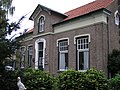
 House in 's-Heer Abtskerke
 -
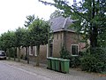
 Clergy house
 -
 House in 's-Heer Abtskerke
 -
 Former school (1964)


References edit
- ^ a b c "Kerncijfers wijken en buurten 2021". Central Bureau of Statistics. Retrieved 19 April 2022.
- ^ "Postcodetool for 4444AA". Actueel Hoogtebestand Nederland (in Dutch). Het Waterschapshuis. Retrieved 19 April 2022.
- ^ "Heer Abtskerke - (geografische naam)". Etymologiebank (in Dutch). Retrieved 19 April 2022.
- ^ a b c d "'s-Heer Abtskerke". Plaatsengids (in Dutch). Retrieved 19 April 2022.
- ^ a b Piet van Cruyningen & Ronald Stenvert (2003). 's-Heer Abtskerke (in Dutch). Zwolle: Waanders. ISBN 90 400 8830 6. Retrieved 19 April 2022.
- ^ a b Ad van der Meer and Onno Boonstra, Repertorium van Nederlandse gemeenten, KNAW, 2011.
- ^ "station 's Gravenpolder- s Heer Abtskerke". Stationsweb (in Dutch). Retrieved 19 April 2022.