Akaroa is a small town on Banks Peninsula in the Canterbury Region of the South Island of New Zealand, situated within a harbour of the same name. The name Akaroa is Kāi Tahu Māori for "Long Harbour", which would be spelled Whangaroa in standard Māori. The area was also named Port Louis-Philippe by French settlers after the reigning French king Louis Philippe I.
Akaroa
Port Louis-Philippe | |
|---|---|
 Akaroa township and its Main Wharf | |
 Akaroa Location of Akaroa in Banks Peninsula | |
| Coordinates: 43°48′15″S 172°58′00″E / 43.80417°S 172.96667°E | |
| Country | New Zealand |
| Region | Canterbury Region |
| District | Christchurch City |
| Ward | Banks Peninsula |
| Community | Te Pātaka o Rākaihautū Banks Peninsula |
| European settlement | 18 August 1840 |
| Founded by | Jean François Langlois |
| Electorates |
|
| Government | |
| • Territorial Authority | Christchurch City Council |
| • Regional council | Environment Canterbury |
| • Mayor of Christchurch | Phil Mauger |
| • Banks Peninsula MP | Vanessa Weenink |
| • Te Tai Tonga MP | Tākuta Ferris |
| Area | |
| • Total | 2.03 km2 (0.78 sq mi) |
| Population (June 2023)[2] | |
| • Total | 770 |
| • Density | 380/km2 (980/sq mi) |
| Postcode | 7520 |
| Local iwi | Ngāi Tahu |
The town is 84 kilometres (52 mi) by road from Christchurch and is the terminus of State Highway 75. It is set on a sheltered harbour and is overlooked and surrounded by the remnants of an eruptive centre of the miocene Banks Peninsula Volcano.[3] Akaroa is entirely dependent upon rainfall on the hills.[4]
Akaroa is a popular resort town. Many Hector's dolphins can be found within the harbour, and 'swim with the dolphins' boat tours are a major tourist attraction.[5][6] Akaroa has become a popular cruise ship destination after the 2011 Canterbury Earthquakes damaged the port of Lyttelton. In the summer of 2009–10, Akaroa was visited by seven cruise ships. This has increased to ninety cruise ships in 2019 and 2020. The numbers reduced to 19 cruise ships in 2022 with the opening of Lyttelton cruise ship berth.[7][8][9]
Ōnuku marae, a marae (tribal meeting ground) of Ngāi Tahu and its Ōnuku Rūnanga branch, is located in Akaroa.[10] It includes the Karaweko wharenui (meeting house).[11]
History edit
In 1830, the Māori settlement at Takapūneke, east of the current town of Akaroa, was the scene of a notorious incident. It followed an earlier incident in 1832 in which Te Rauparaha, fresh from his successful three-month siege of Kaiapoi Pā, took the pā on the Ōnawe Peninsula at the head of Akaroa Harbour. There were an estimated 400 Kāi Tahu in the pā and most were killed, with only the strongest taken as slaves.[12] The captain of the British brig Elizabeth, John Stewart, helped North Island Ngāti Toa chief, Te Rauparaha, to capture the local Kāi Tahu chief, Tama-i-hara-nui, his wife Te Whe and his young daughter, Roimata. The settlement of Takapūneke was sacked. Several hundred were killed and dozens enslaved. Stewart could not be convicted of murder owing to the lack of a suitable legal system in New Zealand at the time. This incident was one of several lawless acts committed by Stewart around this time.[13] The actions of John Stewart were examples of other incidents of lawlessness among Europeans in New Zealand, which contributed to the appointment of an official British Resident James Busby to New Zealand in 1832.[13]
The earliest European settlers used Akaroa as a whaling base. Akaroa is now one of the few whaling bases in New Zealand that still exists as a town.[14]
French settlement edit
.jpg)

In the 1830s, France developed extensive plans for colonial expansion, including into the Pacific, where at that time it had no colonies. This included the South Island of New Zealand. The tiny settlement established at Akaroa can be viewed in the context of that failed, wider project.[15] In 1838, a whaler, Captain Jean François Langlois, wrote up a questionable deed of purchase for "the greater Banks Peninsula" to which twelve Kāi Tahu chiefs each added their moko or cross.[16] The price was 1,000 francs (£40), with a deposit of 150 francs (£6) paid in goods[a] and the remainder to be paid upon Langlois' return from France with settlers.[18][19][17] When the settlers later did arrive, the British authorities – who had in the meantime taken possession of the whole of New Zealand – decided a valid sale had not taken place in 1838, relying for their decision on English law and Māori oral evidence.[20]
While back in France, Langlois raised capital from wealthy businessmen to fund the planned whaling and colonising venture. The Nanto-Bordelaise Company was set up, with the major shareholder being Adolphe Balguerie. Langlois ceded his supposed Banks Peninsula title to the company, took a minor shareholding and was entrusted with the whaling side of the venture.[21]
The company is comparable to the British "New Zealand Association" (later a company) but unlike the British, who arranged for all land sold by the indigenous Māori to go through its government representative, the French government planned to have Māori land sales arranged through the company. The model treaties for land acquisition sent out from France can be compared with the Treaty of Waitangi, used by the British as their way of acquiring Māori land. [22] The French government became involved and to send out the settlers it supplied the warship, Mahé, fitted out as a whaler and renamed Comte de Paris.[20] On 9 March 1840, 63 emigrants left Rochefort. They were accompanied by the Aube, a 28-gun corvette under Commodore Charles-François Lavaud, whose role was also to oversea French whaling interests around New Zealand.
The ships arrived in the Bay of Islands in the North Island on 11 July 1840, where they learned that during their voyage William Hobson had proclaimed British sovereignty over all New Zealand on 21 May, and that the main South Island Māori chiefs had signed the Treaty of Waitangi. Hobson, who was now Governor, wanted there to be no doubt that British sovereignty extended over all New Zealand and so to counter any potential threat to that situation, he dispatched the brig-sloop, HMS Britomart, to call first at Port Nicholson where the New Zealand Company settlers had recently arrived and established their own fledgling government, and thence to Akaroa. Once there, Britomart and fluttering Union Jacks would provide a less than subtle welcome for the soon to arrive French settlers and squash any sovereignty pretentions Lavaud might have had.[23] Back in the Bay of Islands, while discussions on land rights took place, the French colonisation continued. On 18 August 1840, the settlement at Akaroa began, with 57 settlers including 12 Germans. (Some had died en route.)[24][25][26] The settlers' land was around German Bay (Takamatua)[b], French Town (Akaroa) and the hill behind.[28] For the first six years, the settlers were outnumbered by a large contingent of French sailors and naval officers. They were all part of a sizeable infrastructure that included Catholic missionaries, churches, and priests taking classes. In addition, there was a French mayor, French doctors in a French hospital and a French store. There were also French by-laws and a French court of justice.[29] Bishop Pompallier established his first European station in Akaroa in 1840 as the French immigrants were all nominally Catholic. However, he closed the station in disgust, due to the religious apathy of the French immigrants.[30] The area still shows a French influence, prominent in many local place names.[31] It is the oldest town in Canterbury and one of the most historic places in New Zealand.[14]
Meanwhile, the British dismissed the Nanto-Bordelaise Company's claim as it was not based on British law, but only after extensive and complex negotiations had taken place with Māori and the French, represented by Commadore Lavaud and the company's urbane agent, Pierre-Joseph de Belligny. Land ownership discussions dragged on until 1849, and by then both governments back in Europe had become involved. Given that the French colonists had set out for New Zealand on the assumption that they owned the land, Lord Stanley, of the Colonial Office, instructed the New Zealand authorities in 1845 to grant 30,000 acres to the Nanto-Bordelaise Company. This grant never actually happened at that time and the 30,000 acres were never clearly defined, but all concerned acted as if the company now owned that land. The company by then was in a dire financial position[32] and was keen to raise funds by selling that land, which it did before becoming insolvent in 1849. Some land was sold to individual settlers but most was bought by the New Zealand Company, which had still not decided on a place in the area to establish its own settlement. To the indignation of Langlois, the Nanto-Bordelaise Company had sold all its remaining land on the peninsula for £4,500.[19][33] So by 1849, the French settlers were on their own in a British colony.[32]
Before 1840, the area of the current Akaroa town was also known as Wangaloa. The French at first called their settlement Port Louis-Philippe in honour of Louis Philippe I, who reigned as King of the French from 1830 to 1848.[34]
British settlement edit
After being informed of the French intention to colonise Akaroa and to further its use as a whaling port, the Lieutenant-Governor of New Zealand, Captain William Hobson, sent the ship HMS Britomart to proclaim sovereignty over the area for the British Crown. HMS Britomart arrived in Akaroa on 16 August 1840, although the captain's log shows the arrival date as 11 August. Captain Stanley raised the British flag, and held a court at each of the occupied settlements, to convince the French that the area was indeed under British control.[19] A monument at the eastern edge of the town commemorates the British arrival.
James Robinson Clough, also known as Jimmy Robinson, had arrived at Akaroa several years before. He acted as interpreter for Captain Owen Stanley at the flag-raising of 1840, and was the first European to travel up the Avon River / Ōtākaro in 1843. Clough's descendants are still prominent on the Peninsula today.
British immigrants settled in both Akaroa and German Bay (Takamatua), along with many German farmers, who set up dairy, sheep and cocksfoot (Dactylis glomerata) farms. The great majority of the artifacts currently held at Akaroa Museum are of the early farming community and their way of life at the time.
Arriving from England in April 1850, the Monarch, needing repairs, sailed into Akaroa Harbour. It was bound for Auckland however forty of the passengers decided to stay in Akaroa.[35] The British immigrants settled at the southern end of Akaroa with the French living at the northern end with a small bay separating the two.[36]
Akaroa was described in 1854 as “altogether very like a small seaside village in England”. In 1878, there were only ten French born residents in the town of Akaroa out of a population of 642 people. A further 27 French born people lived outside the town boundaries.[35]
Businesses grew in Akaroa and by 1883 there were five builders, four confectioners, eight general stores, five milk-sellers, four shoemakers, two bankers, five milliners and five blacksmiths.[35]
Daly's wharf was built between 1863 and 1865 and refurbished in 1914.[37] Located at the end of Rue Balguerie, it has been used by coastal ships and fishing boats. At the end of the wharf, an octagonal building with a turret roof was built by 1932.[38]
Akaroa was described as a “long favourite holiday haven not only for New Zealanders but visitors from Australia and the Old World” in 1903. At this time, most of Akaroa was concentrated around the waterfront with only a few houses built on the hillsides. The population living in Akaroa was 559 people with a total of 124 houses in 1901.[35]
The main wharf at Akaroa was built in 1887.[39] Plans were made in 2022 to rebuild the main wharf in the same position that it currently is, as it was nearing the end of its useable life.[40] The rebuild is expected to cost $19.1 million and be completed by 30 June 2025.[41]
Demographics edit
Akaroa is defined by Statistics New Zealand as a rural settlement, and covers 2.03 km2 (0.78 sq mi).[1] It had an estimated population of 770 as of June 2023,[2] with a population density of 379 people per km2.
| Year | Pop. | ±% p.a. |
|---|---|---|
| 2006 | 591 | — |
| 2013 | 645 | +1.26% |
| 2018 | 756 | +3.23% |
| Source: [42] | ||
Akaroa had a population of 756 at the 2018 New Zealand census, an increase of 111 people (17.2%) since the 2013 census, and an increase of 165 people (27.9%) since the 2006 census. There were 288 households, comprising 375 males and 378 females, giving a sex ratio of 0.99 males per female. The median age was 55.3 years (compared with 37.4 years nationally), with 63 people (8.3%) aged under 15 years, 108 (14.3%) aged 15 to 29, 339 (44.8%) aged 30 to 64, and 240 (31.7%) aged 65 or older.
Ethnicities were 82.5% European/Pākehā, 6.0% Māori, 0.8% Pasifika, 11.9% Asian, and 2.8% other ethnicities. People may identify with more than one ethnicity.
The percentage of people born overseas was 34.9, compared with 27.1% nationally.
Although some people chose not to answer the census's question about religious affiliation, 44.4% had no religion, 34.9% were Christian, 0.4% had Māori religious beliefs, 1.6% were Hindu, 4.8% were Muslim, 1.6% were Buddhist and 4.0% had other religions.
Of those at least 15 years old, 126 (18.2%) people had a bachelor's or higher degree, and 87 (12.6%) people had no formal qualifications. The median income was $31,800, compared with $31,800 nationally. 81 people (11.7%) earned over $70,000 compared to 17.2% nationally. The employment status of those at least 15 was that 327 (47.2%) people were employed full-time, 111 (16.0%) were part-time, and 9 (1.3%) were unemployed.[42]
Education edit
Akaroa's first primary school opened in 1857, and the first high school followed in 1883. The high school was for boys only in the first year but became co-educational in the second year. However, in 1900 it closed due to a lack of paying students. The next year, it re-opened as a free District High School. It moved to the current site in 1935. In 2007, the primary school was merged with it to form Akaroa Area School.[43] This is now a co-educational composite school covering years 1 to 13,[44] with a roll of 111 as of February 2024.[45]
Museum edit
The Akaroa museum, first opened in 1964, concentrates on the history of Akaroa and the Banks Peninsula. It is located at 71 Rue Lavaud and includes within the museum complex: the 1850s customs house, the 1878 court house and the 1840s Langlois-Eteveneaux cottage.[46][47][48] In 2023, the museum put on an exhibition called Catching Shadows which displayed a photographic history of Banks Peninsula starting in the early 1840s.[49]
Akaroa lighthouse edit
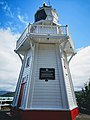
The Akaroa lighthouse has sat at Cemetery Point within the township since 1980. For the 100 years prior to that, it sat 270 feet above sea level on the headland of Akaroa heads. The original site was chosen in 1875 and in 1877 the lens and mount were ordered from France and the mechanism from Scotland. The road to the lighthouse had to be blasted out of solid rock and took ten months to complete. Construction of the lighthouse finally began in 1879. Unfortunately, a southerly storm demolished the framework completely and work had to start from scratch again, this time with a stronger design, The 28-foot-tall light house was completed in 1880 and when operating, its light could be seen 37 kilometres away. A telephone was installed in the lighthouse in 1885, and a kerosene generator was installed in 1935 automating the lighthouse. This was converted to diesel in 1951. In 1977 an automatic lighthouse was built to replace the original staffed lighthouse. In 1980 the original lighthouse was moved in pieces and then reassembled in its current position within the town of Akaroa. The Akaroa lighthouse in open for viewing on Sundays and on days when cruise ships visit the town.[50][51][52][53]
Churches edit
Onuku church edit
This church had its foundation stone laid in November 1876 and was completed in 1878. It is located at the Onuku marae. It was built out of timber with a pitched shingle roof. It has a bell turret and room for 60 parishioners. After falling into disrepair around 1939, work was completed to restore the church and add traditional carved panels to the porch. Services were held regularly until 1963.[54]
Saint Patrick's Catholic church edit
This was the third Catholic church to be built in Akaroa, replacing the two earlier churches. It was designed by Christchurch architects Benjamin Mountfort and Maxwell Bury and built in 1865 out of timber. A porch was added in 1886 and a bell tower in 1893. A stained glass window depicting the crucifixion was added in 1930.[55]
Saint Peter's Anglican church edit
Saint Peter's Anglican church was built out of timber in the Gothic revival style and was completed in 1863. It replaced the previous Anglican church which was built eleven years earlier in 1852. A pipe organ was added in 1869. Benjamin Mountfort designed the transepts and chancel in 1877.[56][57]
Trinity Presbyterian church edit
The Trinity Presbyterian church was completed in 1886, thirty years after the first Presbyterian services were held in a private home. Built in the Gothic revival style with a steep roof, it was designed by Christchurch architect, John Whitelaw. In 1912, a church hall was added. It was listed by Heritage New Zealand as a category two historic place in 1990.[58][59]
-
 Onuku church
 -
 Saint Patrick's Catholic church
 -
 Saint Peter's Anglican church
 -
 Trinity Presbyterian church
.jpg)
,_Akaroa.jpg)
.jpg)

Gallery edit
-
 Akaroa Head Lighthouse (built c. 1878)
 -
 View of Akaroa harbour; the long, thin peninsula extending out into the harbour is Ōnawe Peninsula, and the middle of the volcano
 -
 The Gaiety, Akaroa (built c. 1879)
 -
 Akaroa Main Wharf


.JPG)

Notable residents edit
- Jessie Buckland (1878–1939), photographer[60]
- John Buckland (1844–1909), politician[61][62]
- Bob Parker (born 1953), former mayor of Banks Peninsula and former resident[63]
- William Penlington (1832–1899), sawmiller, builder and mayor of Akaroa[64]
- William Penlington (1890–1982), school principal and educationalist[65]
- Hugh Wilson (born 1945), botanist living at Hinewai Reserve over the hill from Akaroa[63]
- Frank Worsley (1872–1943), sailor and explorer who served on Ernest Shackleton's Imperial Trans-Antarctic Expedition of 1914–1916, as captain of the Endurance[66]
Notes edit
- ^ a b "ArcGIS Web Application". statsnz.maps.arcgis.com. Retrieved 15 October 2021.
- ^ a b "Population estimate tables - NZ.Stat". Statistics New Zealand. Retrieved 25 October 2023.
- ^ Royal Society & February 1958, pp. 207ff.
- ^ "Akaroa water supply". Christchurch City Council. Retrieved 11 July 2017.
- ^ "Swimming with dolphins in Akaroa tops NZ must-dos". ODT. ODT. 28 February 2017. Retrieved 11 July 2017.
- ^ Mitchell, Charlie (18 September 2016). "Ban on new dolphin tourism ventures in Akaroa Harbour". Stuff. Retrieved 11 July 2017.
- ^ "From 90 to 19: Drop in number of cruise ships returning to Banks Peninsula this summer". RNZ. 7 May 2022. Retrieved 24 May 2023.
- ^ "Cruise ship impact on Akaroa needs more research report finds". RNZ. 13 October 2019. Retrieved 24 May 2023.
- ^ Allott, Amber (21 October 2022). "Fewer Hector's dolphins in harbour after cruise ship activity ramped up, study finds". Stuff. Retrieved 24 May 2023.
- ^ "Te Kāhui Māngai directory". tkm.govt.nz. Te Puni Kōkiri.
- ^ "Māori Maps". maorimaps.com. Te Potiki National Trust.
- ^ Ogilvie 2010, p. 13.
- ^ a b "Captain Stewart and the Elizabeth". Ministry for Culture and Heritage. 20 December 2012. Retrieved 7 March 2020.
- ^ a b Ogilvie 2010, p. 20.
- ^ Tremewan 2010, p. 15.
- ^ Tremewan 2010, p. 16-17.
- ^ a b Tremewan 2010, p. 26.
- ^ "French colonists in Akaroa, South Island". New Zealand in History. Retrieved 23 May 2018.
- ^ a b c Andersen, Johannes C. "The Mission of the Britomart at Akaroa, in August, 1840" (PDF). The New Zealand Institute. Retrieved 23 May 2018.
- ^ a b Tremewan 2010, p. 268.
- ^ Tremewan 2010, pp. 55–57.
- ^ Tremewan 2010, p. 16.
- ^ Moon, Paul (2007). The Newest Country in the World - A History of New Zealand in the Decade of the Treaty. Penguin. pp. 47–49. ISBN 9780143006701.
- ^ Tremewan 2010, p. 158.
- ^ King, Michael (2003). The Penguin History of New Zealand. New Zealand: Penguin. pp. 170–1.
- ^ Tremewan 2010, pp. 13–19.
- ^ Tremewan 2010.
- ^ Tremewan 2010, pp. 259–275.
- ^ Tremewan 2010, pp. 18–19.
- ^ King, Michael (2003). The Penguin History of New Zealand. New Zealand: Penguin. pp. 170–1.
- ^ "SettlementatAkaroa".
- ^ a b Tremewan 2010, p. 279.
- ^ Tremewan 2010, pp. 279–293.
- ^ Reed, A. W. (2010). Peter Dowling (ed.). Place Names of New Zealand. Rosedale, North Shore: Raupo. p. 19. ISBN 9780143204107.
- ^ a b c d John Wilson, Louise Beaumont (June 2009). "Akaroa Historical Overview" (PDF). Christchurch City Council. Retrieved 2 June 2023.
- ^ Turner, Gwenda (1977). Akaroa. Dunedin, New Zealand: John McIndoe. p. 14. ISBN 0-908565-41-0.
- ^ "DALY'S WHARF". www.akaroacivictrust.co.nz. Retrieved 22 May 2023.
- ^ "DALY'S WHARF, SHELTER AND SETTING 1A RUE BALGUERIE, AKAROA" (PDF). Christchurch City Council. 15 January 2015. Retrieved 22 May 2023.
- ^ "Akaroa Wharf". Christchurch City Council. Retrieved 22 May 2023.
- ^ "$19.1 million Akaroa Wharf plan progresses". Otago Daily Times Online News. 13 May 2022. Retrieved 22 May 2023.
- ^ "Akaroa Wharf". Christchurch City Council. Retrieved 22 May 2023.
- ^ a b "Statistical area 1 dataset for 2018 Census". Statistics New Zealand. March 2020. Akaroa (333500). 2018 Census place summary: Akaroa
- ^ "Brief School History". Akaroa Area School. Retrieved 25 August 2019.
- ^ Education Counts: Akaroa Area School
- ^ "New Zealand Schools Directory". New Zealand Ministry of Education. Retrieved 14 March 2024.
- ^ "Akaroa Museum | Christchurch NZ". 2 December 2019. Retrieved 9 June 2023.
- ^ "Organisation details | Museums Aotearoa". www.museumsaotearoa.org.nz. Retrieved 9 June 2023.
- ^ "Home : Akaroa Museum". akaroamuseum.org.nz. Retrieved 9 June 2023.
- ^ "Tracing a century of photography on Banks Peninsula". Newsline. 18 April 2023. Retrieved 9 June 2023.
- ^ "Akaroa Lighthouse". Heritage New Zealand. Retrieved 23 May 2023.
- ^ "AKAROA LIGHTHOUSE". www.akaroacivictrust.co.nz. Retrieved 23 May 2023.
- ^ "Akaroa Head". www.doc.govt.nz. Retrieved 23 May 2023.
- ^ "Akaroa Lighthouse Preservation Society » Akaroa & The Bays". www.akaroa.com. Retrieved 23 May 2023.
- ^ "TE WHARE KARAKIA O ŌNUKU AND SETTING – 392 ONUKU ROAD, AKAROA" (PDF). Christchurch City Council. 8 August 2014. Retrieved 21 May 2023.
- ^ "ST PATRICK'S ROMAN CATHOLIC CHURCH". www.akaroacivictrust.co.nz. Retrieved 21 May 2023.
- ^ "ST PETER'S ANGLICAN CHURCH". www.akaroacivictrust.co.nz. Retrieved 21 May 2023.
- ^ "St Peter's Church (Anglican)". Heritage New Zealand. Retrieved 21 May 2023.
- ^ "TRINITY PRESBYTERIAN CHURCH". www.akaroacivictrust.co.nz. Retrieved 21 May 2023.
- ^ "Trinity Church (Presbyterian)". Heritage New Zealand. Retrieved 21 May 2023.
- ^ Main, William. "Jessie Lillian Buckland". Dictionary of New Zealand Biography. Ministry for Culture and Heritage. Retrieved 23 April 2017.
- ^ "Buckland, Jessie Lillian". teara.govt.nz. Retrieved 13 December 2021.
- ^ "Buckland, Jessie Lillian, 1878–1939". National Library of New Zealand. 1 January 1878. Retrieved 13 December 2021.
- ^ a b Easther, Elisabeth (31 January 2014). "Kia ora: Akaroa". The New Zealand Herald. Auckland. Retrieved 18 February 2014.
- ^ Macdonald, George. "William Penlington". Macdonald Dictionary. Canterbury Museum. Retrieved 5 October 2022.
- ^ Boyd, Mary. "William Arthur Greener Penlington". Dictionary of New Zealand Biography. Ministry for Culture and Heritage. Retrieved 10 December 2011.
- ^ Dennerly, P. Y. "Worsley, Frank Arthur". Dictionary of New Zealand Biography. Ministry for Culture and Heritage. Retrieved 15 February 2014.
Explanitory notes edit
- ^ According to the Deed of Purchase, the goods equivalent to the 150 francs deposit were one woollen overcoat, six pairs of cloth trousers, 12 oilskin hats, two pairs of shoes, a pistol, two pairs of red woollen shirts and one oilskin coat.[17]
- ^ It was renamed during the First World War as a mark of anti-German sentiment[27]
References edit
- Ogilvie, Gordon (2010). Banks Peninsula : Cradle of Canterbury (3rd ed.). Phillips & King Publishers. ISBN 978-0-9583315-7-9.
- The Royal Society of New Zealand (February 1958). New Zealand Journal of Geology and Geophysics. The Royal Society of New Zealand. p. 207.
- Tremewan, Peter (2010). French Akaroa (2nd ed.). CUP. ISBN 978-1-877257-97-1.
External links edit
- Images of Akaroa in the 1850s by Charles Meryon
- Land tenure - New Zealand - Canterbury Region
- THE STORY OF THE FRENCH COLONISATION OF AKAROA
- Akaroa official website
- Akaroa Civic Trust
 Akaroa travel guide from Wikivoyage
 Media related to Akaroa at Wikimedia Commons