Conwy (/ˈkɒnwi/, Welsh: [ˈkɔnʊɨ] ⓘ), previously known in English as Conway, is a walled market town, community and the administrative centre of Conwy County Borough in North Wales. The walled town and castle stand on the west bank of the River Conwy, facing Deganwy on the east bank. The town formerly lay in Gwynedd and prior to that in Caernarfonshire. The community, which also includes Deganwy and Llandudno Junction, had a population of 14,753 at the 2011 census.[1]
| Conwy | |
|---|---|
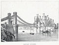
 Conwy Castle and the three bridges over the River Conwy | |
 Conwy Location within Conwy | |
| Population | 14,723 (2011) |
| OS grid reference | SH775775 |
| Community |
|
| Principal area | |
| Preserved county | |
| Country | Wales |
| Sovereign state | United Kingdom |
| Post town | CONWY |
| Postcode district | LL31, LL32 |
| Dialling code | 01492 |
| Police | North Wales |
| Fire | North Wales |
| Ambulance | Welsh |
| UK Parliament | |
| Senedd Cymru – Welsh Parliament | |
Although the community of Conwy straddles the River Conwy, for postal purposes the areas on the east bank form part of the post town of Llandudno Junction, with the Conwy post town being confined to west bank of the river. The ward on the west bank of the river had a population of 4,065 at the 2011 census.[2]
The resident population of the wider Conwy County Borough was estimated to be 116,200 in an ONS-estimate.[3]
The name 'Conwy' derives from the old Welsh words cyn (chief) and gwy (water), the river being originally called the 'Cynwy'.[4][5][6][7]
History edit
,_Wales)_LOC_3752435594.jpg)
Castle and town walls edit

Conwy Castle and the town walls were built, on the instructions of Edward I of England, between 1283 and 1289, as part of his conquest of the principality of Wales.[8] The church standing in Conwy has been marked as the oldest building in Conwy and has stood in the walls of Conwy since the 14th century. However, the oldest structure is part of the town walls, at the southern end of the east side. Here one wall and the tower of a llys (palace/court house) belonging to Llywelyn the Great and his grandson Llywelyn ap Gruffydd have been incorporated into the wall. Built on a rocky outcrop, it has a prominent apsidal tower.[9]
The walls are part of a World Heritage Site, Castles and Town Walls of King Edward in Gwynedd.[10]
People born within the town walls of Conwy are nicknamed "Jackdaws", after the jackdaws which live on the walls there. A Jackdaw Society existed until 2011.[11][12]
The population of the town in 1841 was 1,358.[13]
Abbey edit
Conwy was the original site of Aberconwy Abbey, founded by Llywelyn the Great. Edward and his troops took over the abbey site and moved the monks up the Conwy valley to a new site at Maenan, establishing Maenan Abbey.[14] The parish church St Mary & All Saints still retains some parts of the original abbey church in the east and west walls.[15]
Suspension bridge edit
Conwy has other tourist attractions. Conwy Suspension Bridge, designed by Thomas Telford to replace the ferry, was completed in 1826 and spans the River Conwy next to the castle.[16] Telford designed the bridge's supporting towers to match the castle's turrets. The bridge is now open to pedestrians only and, together with the toll-keeper's house, is in the care of the National Trust.[17]
Railway bridge edit
The Conwy Railway Bridge, a tubular bridge, was built for the Chester and Holyhead Railway by Robert Stephenson. The first tube was completed in 1848, the second in 1849.[18] The bridge is still in use on the North Wales Coast Line, along with the station, which is located within the town walls. In addition to a modern bridge serving the town, the A55 road passes under the river in a tunnel, Britain's first immersed tube tunnel, which was built between 1986 and 1991.[19] The old mountain road to Dwygyfylchi and Penmaenmawr runs through the Sychnant Pass, at the foot of Conwy Mountain.[20]
Aberconwy House edit
The National Trust owns Aberconwy House, which is Conwy's only surviving 14th-century merchant's house, one of the first buildings built inside the walls of Conwy.[21]
Plas Mawr edit
.jpg)
Plas Mawr is an Elizabethan house built in 1576 by the Wynn family, which has been extensively refurbished to its 16th-century appearance and is now in the care of Cadw and open to the public.[22]
Smallest house in Great Britain edit

The house named in the Guinness Book of Records as the Smallest House in Great Britain, with dimensions of 3.05 × 1.8 metres, can be found on the quay. It was in continuous occupation from the 16th century (and was even inhabited by a family at one point) until 1900 when the owner (a 6-foot (1.8 m) fisherman – Robert Jones) was forced to move out on the grounds of hygiene. The rooms were too small for him to stand up in fully. The house is still owned by his descendants today, and visitors can look around it for a small charge.[23]
Vardre Hall edit
Vardre Hall is a 19th-century Grade II listed building directly opposite to Conwy Castle. It was erected by Conservative Buckinghamshire MP William Edward FitzMaurice in the mid 1850s. In 1869 the building was sold to solicitor William Jones. The building was used as a solicitor's office until 1972, when it was bought out and became The Towers Restaurant.[24] After lying empty for a number of years Vardre Hall changed hands again, and in 1999 was refurbished as a shop.[25]
Medieval watchtower edit
Across the estuary is Bodysgallen Hall, which incorporates a medieval tower that was possibly built as a watch tower for Conwy Castle.[26]
Notable locations edit
Conwy Morfa, a marshy spit of land on the west side of the estuary, was probably the location where golf was first played on Welsh soil.[27] It was also the place where Hugh Iorys Hughes developed, and later built, the floating Mulberry Harbour, used in Operation Overlord in World War II.[28]
Conwy Hospital closed in 2003 and has since been demolished.[29]
Transport edit

Conwy railway station opened in 1848.[30] It is located on the North Wales Coast Line, between Crewe and Holyhead. There are through services westbound to Bangor and Holyhead. Eastwards, services travel to Chester, via Colwyn Bay, Rhyl, Prestatyn and Flint; after arrival at Chester, most trains go forward to either Crewe, Cardiff or Birmingham International. Services are operated by Transport for Wales.[31]
Bus services in Conwy are operated mostly by Arriva Wales, with some by Llew Jones Coaches. Routes link the town with Bangor, Caernarfon and Llandudno.[32]
Lifeboat edit
A lifeboat station was established by the RNLI in 1966 and currently operates the D-class inshore lifeboat, the May-Bob, (D–765).[33]
Governance edit

A Conwy electoral ward exists for elections to Conwy County Borough Council. The ward extends west of the River Conwy only with a total population of 4,065.[34] The other county wards within the Conwy community are Deganwy, Marl and Pensarn.[35]
Conwy also has a town council, based at Conwy Guildhall, comprising 17 town councillors elected from the five community wards of Aberconwy, Castle, Deganwy, Marl and Pensarn.[36]
Administrative history edit
Conwy was an ancient borough. Unlike most such boroughs, it was not reformed by the Municipal Corporations Act 1835, and so the old borough corporation continued to exist and run the town. By 1876 the borough corporation was seen as an archaic and unaccountable impediment to the proper management of the town. The town's residents organised a petition to convert the town into a municipal borough with an elected corporation to take responsibility for public health and local government.[37] A royal charter incorporating the town as a municipal borough was issued in December 1876, and the new borough corporation took over the running of the town from March 1877.[38] The municipal borough boundary included land on both sides of the river, covering the parish of Conwy (or Conway) and parts of the parishes of Gyffin and Dwygyfylchi on the west bank, and part of the parish of Eglwys Rhos on the east bank. The urban parishes within the borough boundary were reorganised in 1894 to comprise Conwy and Gyffin on the west bank and Llanrhos on the east bank.[39]
In 1972 the borough council voted to change the spelling of the town's name from "Conway" to "Conwy". The change was agreed by the Secretary of State for Wales and took effect on 1 August 1972.[40] The municipal borough was abolished in 1974, with the area becoming part of the Aberconwy district in the new county of Gwynedd. A community called Conwy was established at the same time covering the area of the former borough.[41] Further local government reorganisation in 1996 saw Aberconwy abolished and the town transferred to the new Conwy County Borough, named after the town but covering a much larger area.[42]
Gallery edit
Images showing changes over time
-
 Conwy castle before the bridge was built, 1795
 -
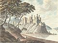
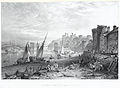
 Conway Town and Castle, 1800
 -
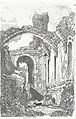
 'Conway Castle: from the wood opposite', 1823
 -
 Conwy Castle, 1838
 -
 Conway Bridge and Castle ca 1840
 -
 The river bank at Conwy with the castle and bridge in the background ca 1850
 -
 Conway c.1850
 -
 'Conway Bridge & Castle' ca 1850
 -
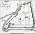
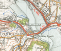 Map of Conwy from 1947
 -
 Conwy Castle - bridge view 2007
 -
 Conwy bridges in 2012
 -
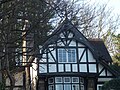 Mock Tudor in Conwy- taken on January 14 2022
_1795.jpg)
.jpeg)


.jpeg)


References edit
- ^ "Town population 2011". Archived from the original on 13 April 2016. Retrieved 21 May 2015.
- ^ "Ward population 2011". Retrieved 21 May 2015.
- ^ "Population - Conwy County Borough Council". Archived from the original on 4 November 2016. Retrieved 3 November 2016.
- ^ Llandudno: its history and natural history, 1861, Richard Parry
- ^ A guide through North Wales, 1860, William Cathrall & Andrew Crombie Ramsay
- ^ Transactions, 1822, Cymmrodorion society
- ^ The pedestrian's guide through North Wales, 1838, George John Bennett
- ^ "Conwy Castle Facts and Information". History for Kids.
- ^ Kenyon, John (2010). The Medieval Castles of Wales. University of Wales Press. p. 20. ISBN 978-0708323632.
- ^ "Castles and Town Walls of King Edward in Gwynedd". UNESCO. Retrieved 15 November 2012.
- ^ "Joining the Jackdaws". BBC Northwest Wales. September 2009. Retrieved 4 April 2012.
- ^ Evans, Kath (11 March 2011). "Jackdaw Society for those Born within Conwy Walls Folds". BBC Northwest Wales. Retrieved 4 April 2012.
- ^ The National Cyclopaedia of Useful Knowledge, Vol.III, (1847) London, Charles Knight, p.1,018
- ^ "Aberconwy Abbey". Ein Treftadaeth (Our Heritage). Retrieved 27 January 2017.
- ^ "St Mary and All Saints, Conwy". churchheritagecymru.org.uk. Retrieved 27 August 2021.
- ^ "Conwy Suspension Bridge". Engineering Timelines. Retrieved 27 January 2017.
- ^ "Conwy Suspension Bridge information". The National Trust. Retrieved 27 November 2022.
- ^ "Conwy Tubular Bridge". Engineering Timelines. Retrieved 27 January 2017.
- ^ "Conwy Immersed Tube Tunnel". Engineering Timelines. Retrieved 28 January 2017.
- ^ "The Sychnant Pass". Great Orme. Retrieved 27 November 2022.
- ^ "Aberconwy House". National Trust Collections. Archived from the original on 18 December 2021. Retrieved 28 January 2017.
- ^ "Plas Mawr - Elizabethan Mansion House Conwy". www.conwy.com.
- ^ Jones, Mari (18 November 2016). "History of the smallest house in Great Britain". northwales. Retrieved 26 May 2017.
- ^ "History Points – Footnotes Vardre Hall, Conwy". historypoints.org. Retrieved 1 October 2018.
- ^ "About Us – The Knight Shop | The Knight Shop". www.theknightshop.com. Retrieved 1 October 2018.
- ^ "History". Bodysgallen Hall & Spa. Retrieved 28 January 2017.
- ^ "History". Conwy Golf Club. Retrieved 28 January 2017.
- ^ "Engineer Biography: Hugh Iorys Hughes". Engineering Timelines. Retrieved 28 January 2017.
- ^ "Conwy Hospital Collection". Archives Hub. Retrieved 26 February 2019.
- ^ Butt, R.V.J. (1995). The Directory of Railway Stations. Yeovil: Patrick Stephens Ltd. p. 68. ISBN 1-85260-508-1. R508.
- ^ "Timetables". Transport for Wales. May 2023. Retrieved 27 May 2023.
- ^ "Bus Services". Bus Times. May 2023. Retrieved 27 May 2023.
- ^ "RNLI: Conwy". Retrieved 16 February 2016.
- ^ "Ward population 2011". Retrieved 21 May 2015.
- ^ "Map of Conwy Wards". Conwy Borough Council. Retrieved 27 November 2022.
- ^ "About Cyngor Tref Conwy Town Council". Cyngor Tref Conwy Town Council. Retrieved 17 March 2018.
- ^ "The inhabitants of Conway". Llangollen Advertiser. 25 February 1876. p. 3. Retrieved 9 November 2022.
- ^ "Conway: Its charter and corporation". North Wales Chronicle. Bangor. 17 March 1877. p. 4. Retrieved 9 November 2022.
- ^ "Conway Municipal Borough". A Vision of Britain through Time. GB Historical GIS / University of Portsmouth. Retrieved 9 November 2022.
- ^ "Borough of Conway". North Wales Weekly News. Conwy. 29 June 1972. p. 10. Retrieved 12 November 2022.
Wheras by resolution of the Council of the Borough of Conway the name of the Borough was changed from "Conway" to "Conwy." And whereas pursuant to the provisions of Section 59 of the Local Government Act 1958, the Secretary of State for Wales has signified his consent to the said change of name, Notice is hereby given that with effect from the first day of August, 1972, the name of the Borough shall be Conwy.
- ^ "Conway Valley Registration District". UKBMD. Retrieved 9 November 2022.
- ^ Johnson, Peter; Jefferis, Catherine (2016). Conwy & District Pubs. Amberley Publishing. ISBN 978-1445653136.