Dorot (Hebrew: דּוֹרוֹת, lit. 'Generations') is a kibbutz in southern Israel. Located on Route 334 near Sderot, it falls under the municipal jurisdiction of the Sha'ar HaNegev Regional Council. In 2022 it had a population of 915.[1]
Dorot
דּוֹרוֹת | |
|---|---|
 | |
 Dorot | |
| Coordinates: 31°30′23″N 34°38′43″E / 31.50639°N 34.64528°E | |
| Country | Israel |
| District | Southern |
| Council | Sha'ar HaNegev |
| Affiliation | Kibbutz Movement |
| Founded | 1941 |
| Founded by | German Jews |
| Population (2022)[1] | 915 |
History edit
Dorot was established during Hanukkah in 1941 by Jewish refugees from Germany, who farmed grain, fruit trees, and vegetables. Soil erosion was a particular problem for the kibbutz.[2] It was named after three members of the Hoz family, Dov, Rivka and Tirtza, who had died in a car accident the year before. The founders were later joined by native Israelis and immigrants from Czechoslovakia and Latvia. In 1947 it had a population of 300.[2]
In the summer of 1946, Dorot and the neighbouring village of Ruhama were occupied by the British army. In their search for illicit arms in the village, the British troops inflicted considerable material damage on the village.[2] During the 1948 Arab-Israeli war, and the battle for the Negev, Dorot was cut off and had to be supplied by air until it was liberated in October 1948.[citation needed]
After 1948, Dorot expanded on the land of the Palestinian Arab village of Huj, which was depopulated during the 1948 Arab–Israeli War.[3]
The Jewish National Fund established a forest on the settlement's land called the Pioneer Women's Forest, funded by donor contributions from the United States.[citation needed]
Climate edit
| Climate data for Dorot (1991–2020) | |||||||||||||
|---|---|---|---|---|---|---|---|---|---|---|---|---|---|
| Month | Jan | Feb | Mar | Apr | May | Jun | Jul | Aug | Sep | Oct | Nov | Dec | Year |
| Record high °C (°F) | 29.7 (85.5) |
32.6 (90.7) |
38.9 (102.0) |
42.4 (108.3) |
45.0 (113.0) |
43.1 (109.6) |
42.5 (108.5) |
40.6 (105.1) |
43.9 (111.0) |
41.9 (107.4) |
36.2 (97.2) |
33.1 (91.6) |
45.0 (113.0) |
| Mean daily maximum °C (°F) | 17.9 (64.2) |
18.9 (66.0) |
21.8 (71.2) |
26.0 (78.8) |
29.4 (84.9) |
31.5 (88.7) |
33.1 (91.6) |
33.5 (92.3) |
32.3 (90.1) |
29.8 (85.6) |
25.1 (77.2) |
20.2 (68.4) |
26.6 (79.9) |
| Daily mean °C (°F) | 12.9 (55.2) |
13.5 (56.3) |
15.7 (60.3) |
18.9 (66.0) |
22.2 (72.0) |
24.9 (76.8) |
26.9 (80.4) |
27.4 (81.3) |
26.1 (79.0) |
23.6 (74.5) |
19.2 (66.6) |
14.9 (58.8) |
20.5 (68.9) |
| Mean daily minimum °C (°F) | 7.9 (46.2) |
8.0 (46.4) |
9.4 (48.9) |
11.8 (53.2) |
15.0 (59.0) |
18.2 (64.8) |
20.6 (69.1) |
21.3 (70.3) |
19.9 (67.8) |
17.4 (63.3) |
13.3 (55.9) |
9.7 (49.5) |
14.4 (57.9) |
| Record low °C (°F) | −2.8 (27.0) |
0.2 (32.4) |
1.3 (34.3) |
3.3 (37.9) |
7.7 (45.9) |
11.2 (52.2) |
15.8 (60.4) |
16.8 (62.2) |
12.5 (54.5) |
10.1 (50.2) |
3.2 (37.8) |
2.0 (35.6) |
−2.8 (27.0) |
| Average precipitation mm (inches) | 110.9 (4.37) |
74.7 (2.94) |
43.3 (1.70) |
8.1 (0.32) |
2.9 (0.11) |
2.3 (0.09) |
0.0 (0.0) |
0.0 (0.0) |
0.1 (0.00) |
17.9 (0.70) |
45.0 (1.77) |
93.7 (3.69) |
398.9 (15.70) |
| Average precipitation days (≥ 1.0 mm) | 8.2 | 7.0 | 4.6 | 1.5 | 0.5 | 0.1 | 0.0 | 0.0 | 0.0 | 1.9 | 4.0 | 6.8 | 34.6 |
| Source: NOAA[4] | |||||||||||||
Notable people edit
- Eliyahu Moyal, Knesset member
Historic photos edit
-
 "Dorot" Kibbutz children evacuated by improvised Armored cars before expected Egyptian attack, 1948
 -
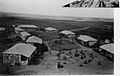 Yiftach 3rd Battalion Headquarters at Kibbutz Dorot in 1948
 -
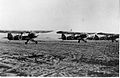 Dorot airfield in 1948


References edit
- ^ a b "Regional Statistics". Israel Central Bureau of Statistics. Retrieved 21 March 2024.
- ^ a b c Jewish National Fund (1949). Jewish Villages in Israel. Jerusalem: Hamadpis Liphshitz Press. pp. 32–33.
- ^ Khalidi, Walid (1992). All That Remains: The Palestinian Villages Occupied and Depopulated by Israel in 1948. Washington D.C.: Institute for Palestine Studies. p. 103. ISBN 0-88728-224-5.
- ^ "World Meteorological Organization Climate Normals for 1991-2020 — Dorot". National Oceanic and Atmospheric Administration. Retrieved January 10, 2024.
External links edit
- Kibbutz website (in Hebrew)