File:(Venice) Bocca di Leone in the Doge's Palace.jpg

Original file(8,670 × 9,552 pixels, file size: 70.46 MB, MIME type: image/jpeg)

Summary

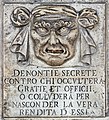
Bocca di Leone in the Doge's Palace (Venice)

Featured picture
Valued image
Valued image

Wikimedia Commons

This is a featured picture on Wikimedia Commons (Featured pictures) and is considered one of the finest images. See its nomination here.
This image has been assessed under the valued image criteria and is considered the most valued image on Commons within the scope Bocca di Leone in the Doge's Palace (Venice).

If you have an image of similar quality that can be published under a suitable copyright license, be sure to upload it, tag it, and nominate it.

Warning The original file is very high-resolution. It might not load properly or could cause your browser to freeze when opened at full size.
Description
Deutsch: Der „Löwenmaul“-Briefkasten am Dogenpalast in Venedig: „Geheime Denunziationen gegen diejenigen, die Gefälligkeiten und Dienste verheimlichen oder sich im Geheimen absprechen, um den wahren Gewinn daraus zu verbergen“.
English: Secret denunciations against anyone who will conceal favors and services or will collude to hide the true revenue from them.
Español: "Boca de león" en el Palacio Ducal de Venecia con el texto «Denuncias secretas contra cualquiera que oculte favores o servicios, o que pretenda ocultar sus verdaderas ganancias».
Français : Dénonciations secrètes contre toute personne qui dissimule des faveurs ou des services, ou qui cherche à cacher ses vrais revenus.
Italiano: "denontie secrete contro chi occultera gratie et officii. o colludera per nasconder la vera rendita d essi"
Русский: Тайные обвинения против любого, кто скрывает милости или услуги, или тайно сговорился, чтобы утаить истинный доход от них.
Українська: «Лев’яча паща» — поштова скринька для анонімних доносів в Палаці дожів, Венеція, Італія.
Переклад напису: «Таємні обвинувачення проти кожного, хто буде приховувати милості та послуги чи таємно змовиться, щоб утаїти істинний дохід від них».
NOTE: This image is a panorama of 2 photos consisting of multiple frames that were merged or stitched in software. As a result, this image necessarily underwent some form of digital manipulation. These manipulations may include blending, blurring, cloning, and colour and perspective adjustments. As a result of these adjustments, the image content may be slightly different from reality at the points where multiple images were combined. This manipulation is often required due to lens, perspective, and parallax distortions.

Boarisch | български | dansk | Deutsch | Zazaki | Ελληνικά | English | Canadian English | British English | Esperanto | español | eesti | suomi | français | hrvatski | magyar | italiano | 日本語 | 한국어 | македонски | മലയാളം | Nederlands | polski | português | русский | sicilianu | slovenščina | svenska | Türkçe | українська | العربية | 中文 | +/−

Date Taken on 4 May 2019
Source Own work
Author Didier Descouens
Permission
(Reusing this file)
This file is copyrighted and has been released under a license which is incompatible with Facebook's licensing terms. It is not permitted to upload this file at Facebook.
I, the copyright holder of this work, hereby publish it under the following license:
w:en:Creative Commons
attribution share alike
This file is licensed under the Creative Commons Attribution-Share Alike 4.0 International license.
You are free:
  • to share – to copy, distribute and transmit the work
  • to remix – to adapt the work
Under the following conditions:
  • attribution – You must give appropriate credit, provide a link to the license, and indicate if changes were made. You may do so in any reasonable manner, but not in any way that suggests the licensor endorses you or your use.
  • share alike – If you remix, transform, or build upon the material, you must distribute your contributions under the same or compatible license as the original.
Object location45° 26′ 03.66″ N, 12° 20′ 25.4″ E Kartographer map based on OpenStreetMap.View this and other nearby images on: OpenStreetMapinfo


Annotations
InfoField
This image is annotated: View the annotations at Commons

Captions

Add a one-line explanation of what this file represents

Items portrayed in this file

depicts

4 May 2019

45°26'3.660"N, 12°20'25.400"E

File history

Click on a date/time to view the file as it appeared at that time.

Date/TimeThumbnailDimensionsUserComment
current07:30, 1 March 2021Thumbnail for version as of 07:30, 1 March 20218,670 × 9,552 (70.46 MB)Archaeodontosaurus{{Information |Description= |Source={{own}} |Date= |Author= Archaeodontosaurus |Permission= |other_versions= }}

Global file usage

The following other wikis use this file:

View more global usage of this file.

Metadata