
Original file (5,471 × 7,501 pixels, file size: 28.75 MB, MIME type: image/jpeg)
| This is a file from the Wikimedia Commons. Information from its description page there is shown below. Commons is a freely licensed media file repository. You can help. |
Summary
| Description |
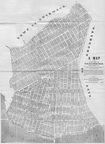
English: A Map of the Village of Williamsburg, Kings County, NY, showing each lot of ground in said village, as laid on the assessment maps of the village, together with the new assessment number of each lot. The village is divided into three districts numbered on, two and three. All west of the centre of Union Avenue, and south of the centre of Grand-street, composes the First District; all west of Union Avenue, and north of Grand-street, composes the Second District; and all east of Union Avenue, the Third District. Made by Isaac Vieth, under the supervision of Henry Payson, Clerk of said Village, November 1845. Present population of Williamsburgh, 11,550.
North is left. |
| Date | |
| Source | Self-scanned |
| Author | Isaac Vieth |
| Permission (Reusing this file) |
public domain |
Licensing
|
This work is in the public domain in its country of origin and other countries and areas where the copyright term is the author's life plus 70 years or fewer.
| |
| This file has been identified as being free of known restrictions under copyright law, including all related and neighboring rights. | |
File history
Click on a date/time to view the file as it appeared at that time.
| Date/Time | Thumbnail | Dimensions | User | Comment | |
|---|---|---|---|---|---|
| current | 16:01, 9 March 2009 | | 5,471 × 7,501 (28.75 MB) | Repliedthemockturtle | {{Information |Description={{en|1=A Map of the Village of Williamsburg, Kings County, NY, showing each lot of ground in said village, as laid on the assessment maps of the village, together with the new assessment number of each lot. The village is divide |
File usage
Global file usage
The following other wikis use this file:
- Usage on ja.wikipedia.org