.PNG)
.PNG&action=edit&redlink=1)
No higher resolution available.
628px-Western_and_Eastern_Roman_Empires_476AD(3).PNG (528 × 259 pixels, file size: 11 KB, MIME type: image/png)
| This is a file from the Wikimedia Commons. Information from its description page there is shown below. Commons is a freely licensed media file repository. You can help. |
.PNG)
Summary

|
File:Western and Eastern Roman Empires 476AD(3).svg is a vector version of this file. It should be used in place of this PNG file when not inferior.
File:628px-Western and Eastern Roman Empires 476AD(3).PNG → File:Western and Eastern Roman Empires 476AD(3).svg
For more information, see Help:SVG. |
.svg) |

|
This map has been uploaded by Electionworld from en.wikipedia.org to enable the |
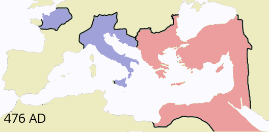
This image is a modified version of File:Western and Eastern Roman Empires 476AD.png on en-Wiki by Geuiwogbil (en-Wiki: G.W.). The modification was done by Bigdaddy1204, for the purpose of fitting in better at Byzantine Empire.
Licensing
I, the copyright holder of this work, hereby publish it under the following licenses:

|
Permission is granted to copy, distribute and/or modify this document under the terms of the GNU Free Documentation License, Version 1.2 or any later version published by the Free Software Foundation; with no Invariant Sections, no Front-Cover Texts, and no Back-Cover Texts. A copy of the license is included in the section entitled GNU Free Documentation License. |
| This file is licensed under the Creative Commons Attribution-Share Alike 3.0 Unported license. | ||
| ||
| This licensing tag was added to this file as part of the GFDL licensing update. |
You may select the license of your choice.
File history
Click on a date/time to view the file as it appeared at that time.
| Date/Time | Thumbnail | Dimensions | User | Comment | |
|---|---|---|---|---|---|
| current | 16:57, 16 June 2019 | | 528 × 259 (11 KB) | SuperSucker | fix - date added |
| 07:38, 2 July 2015 |  | 528 × 259 (23 KB) | Ursus | Rectification carte erronée, plus aucune domination romaine directe sur l'Afrique en 476 | |
| 21:57, 13 December 2006 |  | 528 × 259 (16 KB) | Electionworld | {{ew|en|Bigdaddy1204}} This image is a modified version of Image:Western and Eastern Roman Empires 476AD.png by Geuiwogbil. The modification was done by Bigdaddy1204, for the purpose of fitting in better at [[Byza |
File usage
The following pages on the English Wikipedia use this file (pages on other projects are not listed):
- Campaign history of the Roman military
- History of the Roman Empire
- Kingdom of Soissons
- Roman Empire
- Western Roman Empire
- Western world
- Talk:Byzantine Empire/Archive 3
- Talk:Odoacer
- User:Crudiant/sandbox
- User:Crudiant/sandbox5
- User:Iazyges/WRE format
- User:LuisGomez111/Roman Empire
- User talk:Bigdaddy1204
- Portal:Ancient Rome
Global file usage
The following other wikis use this file:
- Usage on arz.wikipedia.org
- Usage on bg.wikipedia.org
- Usage on ca.wikipedia.org
- Usage on ckb.wikipedia.org
- Usage on cs.wikipedia.org
- Usage on da.wikipedia.org
- Usage on de.wikipedia.org
- Usage on de.wikibooks.org
- Usage on de.wikiversity.org
- Usage on el.wikipedia.org
- Usage on et.wikipedia.org
- Usage on fa.wikipedia.org
- Usage on fi.wikipedia.org
- Usage on fi.wikibooks.org
- Usage on frr.wikipedia.org
- Usage on fr.wikipedia.org
- Usage on fy.wikipedia.org
- Usage on hu.wikipedia.org
- Usage on hy.wikipedia.org
- Usage on it.wikipedia.org
- Usage on it.wikiversity.org
- Usage on ja.wikipedia.org
- Usage on ko.wikipedia.org
- Usage on lt.wikipedia.org
- Usage on nl.wikipedia.org
View more global usage of this file.
.PNG)
.PNG)