
Size of this preview: 320 × 599 pixels. Other resolutions: 256 × 480 pixels | 990 × 1,853 pixels.
Original file (990 × 1,853 pixels, file size: 247 KB, MIME type: image/png)
| This is a file from the Wikimedia Commons. Information from its description page there is shown below. Commons is a freely licensed media file repository. You can help. |
Summary
| Description |
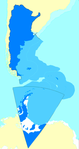
Español: Mapa de la Argentina con todos los territorios reconocidos por su gobierno como propios.
English: Map of Argentina showing all the territories recognized by that country's government as their own.
Français : Carte de l'Argentine incluant tous les territoires reconnus par le gouvernement de ce pays comme étant les leurs. |
| Date |
|
| Source |
English: Updated following the sovereign waters' change as explained here |
| Author | Argentino |
Licensing
This file is licensed under the Creative Commons Attribution-Share Alike 2.5 Generic license.
Attribution: Andrés Baldrich
- You are free:
- to share – to copy, distribute and transmit the work
- to remix – to adapt the work
- Under the following conditions:
- attribution – You must give appropriate credit, provide a link to the license, and indicate if changes were made. You may do so in any reasonable manner, but not in any way that suggests the licensor endorses you or your use.
- share alike – If you remix, transform, or build upon the material, you must distribute your contributions under the same or compatible license as the original.
File history
Click on a date/time to view the file as it appeared at that time.
| Date/Time | Thumbnail | Dimensions | User | Comment | |
|---|---|---|---|---|---|
| current | 18:59, 5 September 2009 | | 990 × 1,853 (247 KB) | Argentino | en: Added the changes in the continental shelf the argentinian government sent to the UN SOURCE: the UNITED NATIONS' OFFICIAL PAGE WWW.UN.ORG - READ BEFORE FLAMING http://www.un.org/Depts/los/clcs_new/submissions_files/arg25_09/arg2009e_summary_esp.pdf |
| 21:36, 25 August 2006 |  | 990 × 1,853 (328 KB) | Argentino | Map of Argentina showing all the territories recognized by that country's governmet as their own. Mapa de la Argentina con todos los territorios reconocidos por su gobierno como propios. Created by me following the proportion of distances exactly as fo |
File usage
The following pages on the English Wikipedia use this file (pages on other projects are not listed):
Global file usage
The following other wikis use this file:
- Usage on af.wikipedia.org
- Usage on ast.wikipedia.org
- Usage on da.wikipedia.org
- Usage on de.wikipedia.org
- Usage on eo.wikipedia.org
- Usage on es.wikipedia.org
- Antártida Argentina
- Irredentismo
- Espacio marítimo argentino
- Anexo:Puntos extremos de Argentina
- Wikiproyecto Discusión:Argentina/Archivo 2006
- Usuario:ENRIQUE GUARDIA
- Anexo:Países transcontinentales
- Discusión:Mar Argentino
- Usuario Discusión:Nerêo/2009
- Usuario discusión:Eduardomanuel
- Irredentismo argentino
- Usuario:Rosarigasinazo
- Usuario:Cacen Gymraeg/Bar del Atlántico Sur
- Usage on es.wikivoyage.org
- Usage on fr.wikipedia.org
- Usage on gl.wikipedia.org
- Usage on id.wikipedia.org
- Usage on it.wikipedia.org
- Usage on ja.wikipedia.org
- Usage on mk.wikipedia.org
- Usage on no.wikipedia.org
- Usage on pl.wikipedia.org
- Usage on pt.wikipedia.org
- Usage on rm.wikipedia.org
- Usage on ru.wikipedia.org
- Usage on sk.wikipedia.org
- Usage on uk.wikipedia.org
- Usage on www.wikidata.org