
Size of this PNG preview of this SVG file: 800 × 393 pixels. Other resolutions: 320 × 157 pixels | 640 × 314 pixels | 1,024 × 503 pixels | 1,280 × 629 pixels | 2,560 × 1,257 pixels | 2,574 × 1,264 pixels.
Original file (SVG file, nominally 2,574 × 1,264 pixels, file size: 464 KB)
| This is a file from the Wikimedia Commons. Information from its description page there is shown below. Commons is a freely licensed media file repository. You can help. |
 | This image was previously a featured picture, but community consensus determined that it no longer meets our featured-picture criteria. If you have a high-quality image that you believe meets the criteria, be sure to upload it, using the proper free-license tag, then add it to a relevant article and nominate it. |
Summary
| Description |
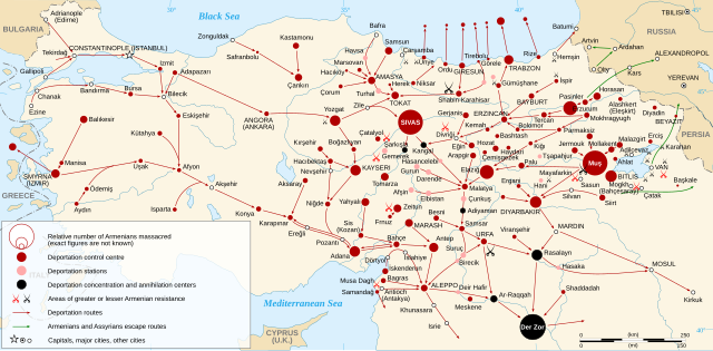
English: Map of the Armenian Genocide in 1915.
Español: Mapa del genocidio armenio en 1915. Français : Carte en anglais du génocide arménien de 1915. Русский: Карта геноцида армян 1915 года. |
| Date | |
| Source |
Other data :
|
| Author | Sémhur |
| Other versions |
[]
|
| SVG development |


| Camera location | | View this and other nearby images on: OpenStreetMap |
|---|
Assessment
|
Licensing
I, the copyright holder of this work, hereby publish it under the following licenses:

|
Permission is granted to copy, distribute and/or modify this document under the terms of the GNU Free Documentation License, Version 1.2 or any later version published by the Free Software Foundation; with no Invariant Sections, no Front-Cover Texts, and no Back-Cover Texts. A copy of the license is included in the section entitled GNU Free Documentation License. |
This file is licensed under the Creative Commons Attribution-Share Alike 3.0 Unported, 2.5 Generic, 2.0 Generic and 1.0 Generic license.
- You are free:
- to share – to copy, distribute and transmit the work
- to remix – to adapt the work
- Under the following conditions:
- attribution – You must give appropriate credit, provide a link to the license, and indicate if changes were made. You may do so in any reasonable manner, but not in any way that suggests the licensor endorses you or your use.
- share alike – If you remix, transform, or build upon the material, you must distribute your contributions under the same or compatible license as the original.
You may select the license of your choice.
File history
Click on a date/time to view the file as it appeared at that time.
| Date/Time | Thumbnail | Dimensions | User | Comment | |
|---|---|---|---|---|---|
| current | 22:07, 24 April 2021 | | 2,574 × 1,264 (464 KB) | Pta345MK | Reverted to version as of 22:01, 8 March 2021 (UTC) |
| 22:04, 24 April 2021 |  | 2,574 × 1,264 (629 KB) | Pta345MK | File uploaded using svgtranslate tool (https://svgtranslate.toolforge.org/). Added translation for mk. | |
| 21:33, 24 April 2021 |  | 2,574 × 1,264 (464 KB) | Pta345MK | Reverted to version as of 22:01, 8 March 2021 (UTC) | |
| 21:31, 24 April 2021 |  | 2,574 × 1,264 (629 KB) | Pta345MK | File uploaded using svgtranslate tool (https://svgtranslate.toolforge.org/). Added translation for mk. | |
| 22:01, 8 March 2021 |  | 2,574 × 1,264 (464 KB) | 4nn1l2 | "ISTANBUL" to "CONSTANTINOPLE (ISTANBUL)" per this // Editing SVG source code using c:User:Rillke/SVGedit.js | |
| 19:48, 3 April 2011 |  | 2,574 × 1,264 (464 KB) | Hayk | fix typo | |
| 19:35, 3 April 2011 |  | 2,574 × 1,264 (464 KB) | Hayk | fix typos | |
| 15:08, 13 February 2011 |  | 2,574 × 1,264 (509 KB) | Kathovo | typos, added more town names. | |
| 19:04, 6 February 2008 |  | 2,574 × 1,264 (482 KB) | Sémhur | == Description == {{Information |Description= {{en|Map of the Armenian Genocide in 1915.}} {{fr|Carte en anglais du génocide arménien de 1915.}} |Source=Own work. Sources : * Topographic background |
File usage
The following pages on the English Wikipedia use this file (pages on other projects are not listed):
- Armenia without Armenians
- Armenian genocide
- Armenian genocide denial
- Armenian highlands
- History of Armenia
- Sürgün
- Timeline of modern Armenian history
- United Armenia
- Western Armenia
- Talk:Armenian genocide/Archive 27
- Talk:List of massacres in Turkey
- User:Amakuru/POTD 14
- User:Amakuru/PotdMainPageSandbox
- User:Amakuru/PotdSandbox
- User:Falcaorib
- User:Kevo327
- User:Kevo327/Userboxes/Against Denial
- User:Yerevantsi/Western Armenia
- User:Yerevantsi/sandbox/azatagrakan
- User talk:EtienneDolet/Archive 2
- User talk:EtienneDolet/Archive 7
- User talk:Sémhur
- Wikipedia:Featured picture candidates/Armenian Genocide
- Wikipedia:Featured picture candidates/May-2013
- Wikipedia:Featured picture candidates/delist/2019
- Wikipedia:Featured picture candidates/delist/Armenian Genocide
- Wikipedia:WikiProject Armenia/Recognized content
- Wikipedia:WikiProject Former countries/Recognized content
- Wikipedia:WikiProject Military history/Featured content
- Wikipedia:WikiProject Military history/News/July 2021/Articles
- Wikipedia:WikiProject Military history/News/June 2013/Articles
- Wikipedia:WikiProject Military history/Showcase
- Wikipedia:WikiProject Military history/Showcase/FP
- Wikipedia:WikiProject Turkey/Recognized content
- Wikipedia:WikiProject Turkey/StatusArticleList
- Wikipedia:Wikipedia Signpost/2013-05-13/Featured content
- Wikipedia:Wikipedia Signpost/Single/2013-05-13
- Template talk:POTD/2019-04-24/Pulled
- Portal:History/Recognized content
Global file usage
The following other wikis use this file:
- Usage on an.wikipedia.org
- Usage on ast.wikipedia.org
- Usage on bn.wikipedia.org
- Usage on ca.wikipedia.org
- Usage on cs.wikipedia.org
- Usage on el.wikipedia.org
- Usage on en.wikiquote.org
- Usage on en.wikiversity.org
- Usage on eo.wikipedia.org
- Usage on fa.wikipedia.org
- Usage on fr.wikipedia.org
- Usage on fr.wikinews.org
- Usage on ga.wikipedia.org
- Usage on gl.wikipedia.org
- Usage on he.wikipedia.org
- Usage on hr.wikipedia.org
- Usage on hy.wikipedia.org
- Usage on id.wikipedia.org
- Usage on it.wikipedia.org
- Usage on ja.wikipedia.org
- Usage on ka.wikipedia.org
- Usage on kn.wikipedia.org
- Usage on lad.wikipedia.org
- Usage on lmo.wikipedia.org
- Usage on lv.wikipedia.org
- Usage on mk.wikipedia.org
- Usage on pt.wikipedia.org
- Usage on sk.wikipedia.org
- Usage on zh.wikipedia.org