No higher resolution available.
Boston_Fed_map.png (188 × 259 pixels, file size: 5 KB, MIME type: image/png)
| This is a file from the Wikimedia Commons. Information from its description page there is shown below. Commons is a freely licensed media file repository. You can help. |

|
This locator map image could be re-created using vector graphics as an SVG file. This has several advantages; see Commons:Media for cleanup for more information. If an SVG form of this image is available, please upload it and afterwards replace this template with
{{vector version available|new image name}}.
It is recommended to name the SVG file “Boston Fed map.svg”—then the template Vector version available (or Vva) does not need the new image name parameter. |
Summary
| Description |
Français : Carte de la première circonscription de la Réserve fédérale des États-Unis
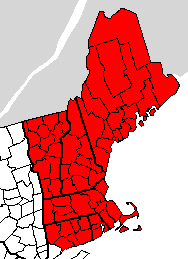
English: Map of the First District of the Federal Reserve System
Español: Mapa de la Primera Circunscripción de la Sistema de Reserva Federal |
| Date | (UTC) |
| Source |
This file was derived from: Map of USA with county outlines (black & white).png: |
| Author |
|
.png)
| This is a retouched picture, which means that it has been digitally altered from its original version. Modifications: Added colors and cropped. The original can be viewed here: Map of USA with county outlines (black & white).png:
|
Licensing
I, the copyright holder of this work, hereby publish it under the following licenses:
| This file is licensed under the Creative Commons Attribution-Share Alike 3.0 Unported license. Subject to disclaimers. | ||
| ||
| This licensing tag was added to this file as part of the GFDL licensing update. |

|
Permission is granted to copy, distribute and/or modify this document under the terms of the GNU Free Documentation License, Version 1.2 or any later version published by the Free Software Foundation; with no Invariant Sections, no Front-Cover Texts, and no Back-Cover Texts. A copy of the license is included in the section entitled GNU Free Documentation License. Subject to disclaimers. |
You may select the license of your choice.
Original upload log
This image is a derivative work of the following images:
- File:Map_of_USA_with_county_outlines_(black_&_white).png licensed with Cc-by-sa-3.0-migrated-with-disclaimers, GFDL-en
- 2006-09-25T09:34:33Z Poulpy 1513x983 (57353 Bytes) {{Information |Description=Map of the [[USA]] showing borders of states and counties. Adapted by [[:en:User:Wapcaplet|Wapcaplet]] from a public-domain map courtesy of the [http://www.census.gov/ U.S. Census Bureau website]. |S
Uploaded with derivativeFX
File history
Click on a date/time to view the file as it appeared at that time.
| Date/Time | Thumbnail | Dimensions | User | Comment | |
|---|---|---|---|---|---|
| current | 14:23, 6 April 2012 | | 188 × 259 (5 KB) | Presidentman | == {{int:filedesc}} == {{Information |Description={{fr|Carte de la Federal Reserve Bank de Boston}} {{en|Map of the w:Federal Reserve Bank of Boston}} {{es|Mapa de la Reserva Federal de Boston}} |Source={{Derived from|Map_of_USA_with_county_outline... |
File usage
The following pages on the English Wikipedia use this file (pages on other projects are not listed):
Global file usage
The following other wikis use this file:
- Usage on ru.wikipedia.org
- Usage on sv.wikipedia.org
- Usage on uk.wikipedia.org