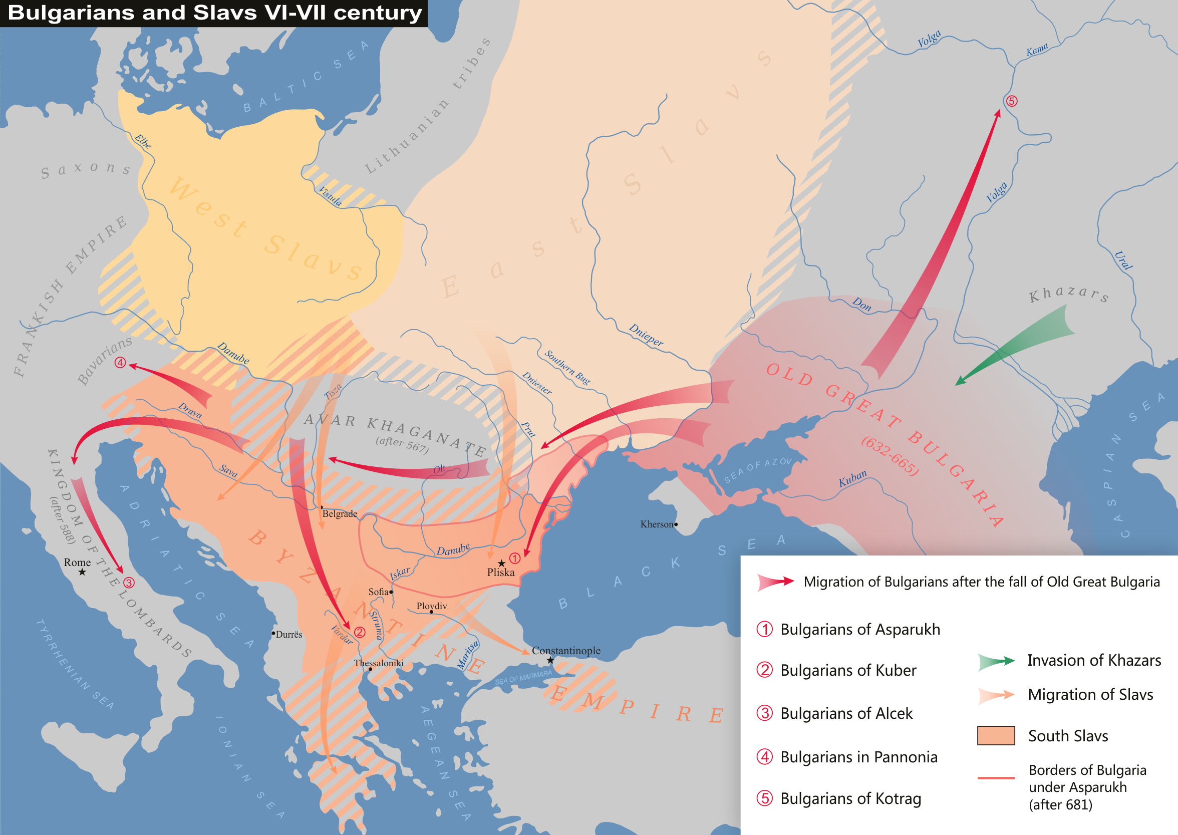
Size of this preview: 800 × 567 pixels. Other resolutions: 320 × 227 pixels | 640 × 454 pixels | 1,024 × 726 pixels | 1,280 × 907 pixels | 2,352 × 1,667 pixels.
Original file (2,352 × 1,667 pixels, file size: 793 KB, MIME type: image/png)
| This is a file from the Wikimedia Commons. Information from its description page there is shown below. Commons is a freely licensed media file repository. You can help. |

|
This ethnographic map image could be re-created using vector graphics as an SVG file. This has several advantages; see Commons:Media for cleanup for more information. If an SVG form of this image is available, please upload it and afterwards replace this template with
{{vector version available|new image name}}.
It is recommended to name the SVG file “Bulgarians and Slavs VI-VII century.svg”—then the template Vector version available (or Vva) does not need the new image name parameter. |
Summary
| Description |
English: Bulgarians and Slavs VI-VII century
Български: Българи и славяни през VІ-VІІ век
Português: Búlgaros e eslavos nos séculos VI-VII
Based on map "Славяни и прабългари през VІ и VІІв." in atlas "Атлас по история на България за средните училища", "Картография", София, 1990 г. |
| Date | |
| Source | Own work |
| Author | Kandi |
| Other versions | File:Bulgarians and Slavs VI-VII century-pt.svg (in Portuguese) File:Bulgarians and Slavs VI-VII century hu.svg (magyar) |
Licensing
| I, the copyright holder of this work, release this work into the public domain. This applies worldwide. In some countries this may not be legally possible; if so: I grant anyone the right to use this work for any purpose, without any conditions, unless such conditions are required by law. |
File history
Click on a date/time to view the file as it appeared at that time.
| Date/Time | Thumbnail | Dimensions | User | Comment | |
|---|---|---|---|---|---|
| current | 21:18, 23 April 2019 | | 2,352 × 1,667 (793 KB) | Kandi | Reverted to version as of 18:28, 21 January 2017 (UTC) |
| 13:09, 6 November 2017 |  | 2,352 × 1,667 (856 KB) | Ceha | South slavic tribes occupied more of adriatic costline (triangle Nin-Knin-Klis was the centre of croatian core state...). | |
| 18:28, 21 January 2017 |  | 2,352 × 1,667 (793 KB) | Kandi | original | |
| 17:11, 21 January 2017 |  | 2,352 × 1,667 (721 KB) | MAXHO | Contrast West & East Slavs, some details | |
| 14:51, 21 October 2016 |  | 2,352 × 1,667 (793 KB) | Kandi | new version | |
| 11:09, 11 October 2016 |  | 1,007 × 735 (511 KB) | Kandi | Reverted to version as of 06:51, 16 January 2009 (UTC) | |
| 10:19, 11 October 2016 |  | 1,007 × 735 (528 KB) | Julieta39 | Little details acconding with H. E. Stier & 15 al., Grosser Atlas zur Weltgeschichte, Westermann Verlag, Braunschweig 1985, ISBN-3141009198, p. 49-51, 55-59. | |
| 06:51, 16 January 2009 |  | 1,007 × 735 (511 KB) | Kandi | {{Information |Description={{en|1=Bulgarians and Slavs VI-VII century}} {{bg|1=Българи и славяни през VІ-VІІ век}} |Source=Собствена творба (Own work of the uploader) |Author=Kandi |Date= |Permission= |
File usage
The following pages on the English Wikipedia use this file (pages on other projects are not listed):
Global file usage
The following other wikis use this file:
- Usage on azb.wikipedia.org
- Usage on az.wikipedia.org
- Usage on ba.wikipedia.org
- Usage on be.wikipedia.org
- Usage on bg.wikipedia.org
- Usage on ceb.wikipedia.org
- Usage on cs.wikipedia.org
- Usage on cv.wikipedia.org
- Usage on de.wikipedia.org
- Usage on de.wikibooks.org
- Usage on de.wikiversity.org
- Usage on el.wikipedia.org
- Usage on et.wikipedia.org
- Usage on fr.wikipedia.org
- Usage on id.wikipedia.org
- Usage on it.wikipedia.org
- Usage on ja.wikipedia.org
- Usage on ka.wikipedia.org
- Usage on kk.wikipedia.org
- Usage on ko.wikipedia.org
- Usage on lv.wikipedia.org
- Usage on mk.wikipedia.org
View more global usage of this file.