No higher resolution available.
Colorado_population_map.png (700 × 400 pixels, file size: 109 KB, MIME type: image/png)
| This is a file from the Wikimedia Commons. Information from its description page there is shown below. Commons is a freely licensed media file repository. You can help. |
Summary
| Description |
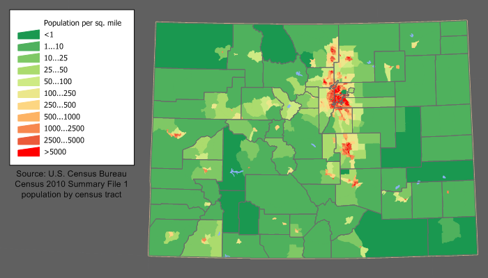
English: en:Category:U.S. State Population Maps
en:Category:Colorado maps en:Category:Images of Colorado Colorado state population density map based on Census 2010 data. See the data lineage for a process description. |
| Date | 9 March 2006 (original upload date) |
| Source | Transferred from en.wikipedia to Commons. |
| Author | JimIrwin at English Wikipedia |
Licensing
JimIrwin at the English-language Wikipedia, the copyright holder of this work, hereby publishes it under the following license:

|
Permission is granted to copy, distribute and/or modify this document under the terms of the GNU Free Documentation License, Version 1.2 or any later version published by the Free Software Foundation; with no Invariant Sections, no Front-Cover Texts, and no Back-Cover Texts. A copy of the license is included in the section entitled GNU Free Documentation License. |
| This file is licensed under the Creative Commons Attribution-Share Alike 3.0 Unported license. | ||
| Attribution: JimIrwin | ||
| ||
| This licensing tag was added to this file as part of the GFDL licensing update. |
Original upload log
The original description page was here. All following user names refer to en.wikipedia.
- 2006-03-09 21:08 JimIrwin 700×380×8 (26508 bytes) [[Category:U.S. State Population Maps]] Colorado state population density map based on Census 2000 data. See the [[User:JimIrwin/Lineage_of_population_maps|data lineage]] for a process description.
File history
Click on a date/time to view the file as it appeared at that time.
| Date/Time | Thumbnail | Dimensions | User | Comment | |
|---|---|---|---|---|---|
| current | 14:00, 11 December 2011 | | 700 × 400 (109 KB) | JimIrwin | 2010 census update |
| 18:47, 20 April 2008 |  | 700 × 380 (26 KB) | File Upload Bot (Magnus Manske) | {{BotMoveToCommons|en.wikipedia}} {{Information |Description={{en|en:Category:U.S. State Population Maps en:Category:Colorado maps en:Category:Images of Colorado Colorado state population density map based on Census 2000 data. See the [[: |
File usage
The following pages on the English Wikipedia use this file (pages on other projects are not listed):
Global file usage
The following other wikis use this file:
- Usage on de.wikipedia.org
- Usage on fr.wikipedia.org
- Usage on he.wikipedia.org
- Usage on hu.wikipedia.org
- Usage on incubator.wikimedia.org
- Usage on ja.wikipedia.org
- Usage on ko.wikipedia.org
- Usage on pl.wikipedia.org
- Usage on ro.wikipedia.org
- Colorado
- Colorado (dezambiguizare)
- Categorie:Statul Colorado, SUA
- Format:Colorado stat SUA
- Denver
- Colorado Springs
- Categorie:Liste Colorado
- Listă de oameni din statul Colorado
- Listă de comitate din statul Colorado
- Categorie:Guvernul statului Colorado
- Comitatul San Juan, Colorado
- Categorie:Vulcani din Colorado
- Categorie:Comitatul Montezuma, Colorado
- Comitatul Adams, Colorado
- Pagosa Springs, Colorado
- Categorie:Zone metropolitane din Colorado
- Categorie:Zone micropolitane din Colorado
- Boulder, Colorado
- Categorie:Localități din Colorado
- Categorie:Comitatul Boulder, Colorado
- Categorie:Regiuni ale statului Colorado
- Categorie:Dezastre naturale din statul Colorado
- Gunnison, Colorado
- Categorie:Comitatul El Paso, Colorado
- Categorie:Atracții turistice din Colorado
- Categorie:Membri ai legislaturii statului Colorado
- Categorie:Localități din Colorado după comitat
- Categorie:Geografia statului Colorado după comitat
- Categorie:Localități din comitatul Gunnison, Colorado
- Comitatul Rio Blanco, Colorado
- Categorie:Absolvenți din Colorado după instituția de învățământ superior
- Categorie:Geografia statului Colorado
- Categorie:Oameni din statul Colorado după institutul de învățământ superior
- Categorie:Târguri din statul Colorado
- Categorie:Municipalități din statul Colorado
- Categorie:Localități din comitatul Archuleta, Colorado
- Categorie:Geografia comitatului Adams, Colorado
- Categorie:Geografia comitatului Arapahoe, Colorado
- Categorie:Geografia comitatului Archuleta, Colorado
- Categorie:Geografia comitatului Boulder, Colorado
View more global usage of this file.