
Original file (5,776 × 4,184 pixels, file size: 8.61 MB, MIME type: image/jpeg)
| This is a file from the Wikimedia Commons. Information from its description page there is shown below. Commons is a freely licensed media file repository. You can help. |

|
This map image could be re-created using vector graphics as an SVG file. This has several advantages; see Commons:Media for cleanup for more information. If an SVG form of this image is available, please upload it and afterwards replace this template with
{{vector version available|new image name}}.
It is recommended to name the SVG file “DESERTEC-Map large.svg”—then the template Vector version available (or Vva) does not need the new image name parameter. |


| Description |
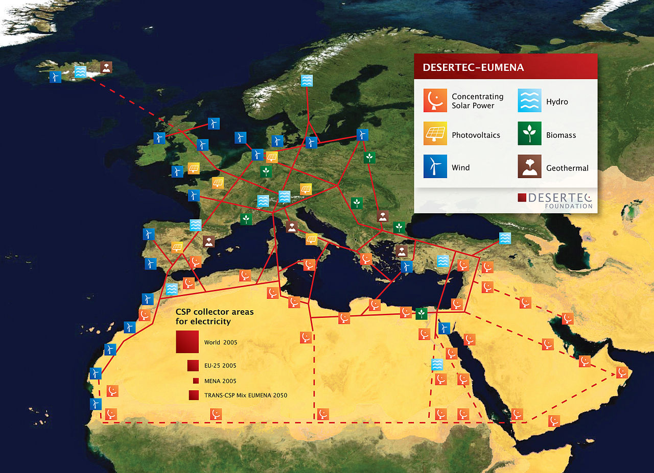
English: DESERTEC EU-MENA Map: Sketch of possible infrastructure for a sustainable supply of power to Europe, the Middle East and North Africa (EU-MENA) proposed by TREC)
For illustration: The red squares represent the total surfaces needed for solar collectors of Concentrating Solar Thermal Power (CSP) plants to provide the present electricity demands - for the world (18.000 TWh/a, 300x300 km) - for Europe (EU 3.200 TWh/a, 125x125 km) - and for Germany or MENA (Middle East and North Africa, about 600 TWh/a, 55x55 km). - The square labeled "TRANS-CSP Mix EUMENA 2050" indicates the surface needed for solar collectors to realize DESERTEC in EU-MENA (according to the TRANS-CSP scenario by DLR). This way the needs for seawater desalination and about two-thirds of the rising electricity consumption in the MENA region could be provided and about 17 percent of the European electricity consumption in 2050 (2,940 TWh/a, 120x120 km² in total). In reality numerous CSP-Plants will be spread in the deserts of EU-MENA and around the globe.
Deutsch: DESERTEC EU-MENA Karte: Skizze einer möglichen Infrastruktur für eine nachhaltige Stromversorgung in Europa, dem Nahen Osten und Nord-Afrika (EU-MENA).
Zur Veranschaulichung: Die durch die roten Quadrate markierten Flächen für Solarkollektoren würden genügen, um in solarthermischen Kraftwerken (CSP) den Strombedarf - der Welt (18.000 TWh/a, 300x300 km), - Europas (EU, 3.200 TWh/a, 125x125 km) - und von Deutschland bzw. MENA (Middle East and North Africa, ca. 600 TWh/a, 55x55 km) zu erzeugen. - Das Quadrat "TRANS-CSP Mix EUMENA 2050" zeigt die insgesamt benötigte Fläche für Solarkollektoren, um DESERTEC in EU-MENA zu realisieren (entsprechend dem TRANS-CSP Szenario des DLR). Auf diese Weise könnte genügend Energie erzeugt werden, um den Bedarf an Meerwasserentsalzung und zwei Drittel des bis 2050 stark wachsenden Strombedarfs der MENA-Region zu decken sowie etwa 17 Prozent des europäischen Strombedarfs (zusammen 2,940 TWh/a, 120x120 km). In der Realität werden viele CSP-Kraftwerke über die Wüsten der MENA-Region und der Welt verteilt sein. Die gestrichelten Linien stellen eine zweite Ausbaustufe dar. |
| Date | |
| Source | http://www.desertec.org/fileadmin/downloads/press/DESERTEC-Map.zip |
| Author | DESERTEC Foundation, www.desertec.org |
| Permission (Reusing this file) |
This file is licensed under the Creative Commons Attribution-Share Alike 2.5 Generic license.
|
| Other versions |
|

File history
Click on a date/time to view the file as it appeared at that time.
| Date/Time | Thumbnail | Dimensions | User | Comment | |
|---|---|---|---|---|---|
| current | 19:40, 7 February 2011 | | 5,776 × 4,184 (8.61 MB) | Benderson2~commonswiki | Udated version http://www.desertec.org/en/press/ without symols in the Western Sahara conflict region. |
| 17:39, 5 March 2009 |  | 5,777 × 4,185 (8.09 MB) | Chstdu | {{Information |Description={{en|1=Sketch of possible infrastructure for a sustainable supply of power to EUrope, the Middle East and North Africa (EU-MENA) (Euro-Supergrid with a EU-MENA-Connection proposed by [[w:Trans-Mediterranean_Renewable_Energy_Coop |
File usage
Global file usage
The following other wikis use this file:
- Usage on ar.wikipedia.org
- Usage on ca.wikipedia.org
- Usage on ckb.wikipedia.org
- Usage on cs.wikipedia.org
- Usage on de.wikipedia.org
- Sonnenenergie
- Europäisches Verbundsystem
- Erneuerbare Energien
- Desertec
- Energiewende
- Diskussion:Desertec/Archiv/1
- Wikipedia Diskussion:Hauptseite/Artikel des Tages/Archiv/Vorschläge/2011/1
- Wikipedia Diskussion:Hauptseite/Artikel des Tages/Archiv/Vorschläge/2012/2
- Wikipedia:Hauptseite/Archiv/10. November 2012
- Usage on eo.wikipedia.org
- Usage on es.wikipedia.org
- Usage on fi.wikipedia.org
- Usage on fr.wikipedia.org
- Usage on fr.wikiversity.org
- Usage on hr.wikipedia.org
- Usage on hu.wikipedia.org
- Usage on it.wikipedia.org
- Usage on ja.wikipedia.org
- Usage on pt.wikipedia.org
- Usage on ru.wikipedia.org
- Usage on shi.wikipedia.org
- Usage on sh.wikipedia.org
- Usage on sv.wikipedia.org
- Usage on uk.wikipedia.org
- Usage on vi.wikipedia.org
- Usage on www.wikidata.org
- Usage on zh.wikipedia.org