Dampier_Mosquito.gif (500 × 375 pixels, file size: 14 KB, MIME type: image/gif)
| This is a file from the Wikimedia Commons. Information from its description page there is shown below. Commons is a freely licensed media file repository. You can help. |
| Description |
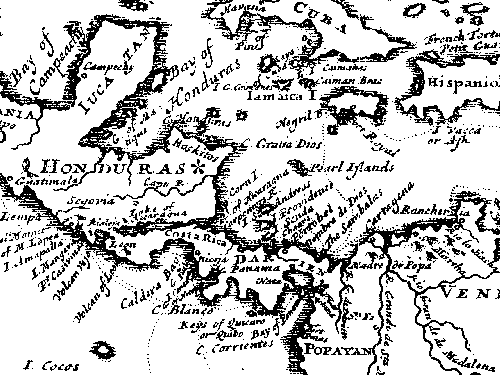
English: This map is from "A New Voyage Round the World", published in 1697 by William Dampier, the English sea captain, naturalist, and occasional pirate.
The Miskito coast is marked with a star. Dampier and his associate, the surgeon Lionel Wafer describe the Miskito peoples in the period 1690-1700. These tribal groups, often mixed with runaway slaves, formed a distinct culture in the coastal region, sometimes forming alliances with pirates against Spanish authorities in the 16th-18th centuries. |
| Source | |
| Author |
Licensing
|
This work is in the public domain in its country of origin and other countries and areas where the copyright term is the author's life plus 70 years or fewer.
| |
| This file has been identified as being free of known restrictions under copyright law, including all related and neighboring rights. | |
Original upload log
All following user names refer to en.wikipedia.
- 2007-06-29 02:41 Victor falk 500×375× (13914 bytes) This map is from "A New Voyage Round the World", published in 1697 by William Dampier, the English sea captain, naturalist, and occasional pirate. The Miskito coast is marked with a star. Dampier and his associate, the surgeon Lionel Wafer describe the
File history
Click on a date/time to view the file as it appeared at that time.
| Date/Time | Thumbnail | Dimensions | User | Comment | |
|---|---|---|---|---|---|
| current | 09:42, 16 October 2009 | | 500 × 375 (14 KB) | Urdangaray | {{Information |Description={{en|This map is from "A New Voyage Round the World", published in 1697 by William Dampier, the English sea captain, naturalist, and occasional pirate. The Miskito coast is marked with a star. Dampier and his associate, the su |
File usage
Global file usage
The following other wikis use this file:
- Usage on az.wikipedia.org
- Usage on es.wikipedia.org
- Usage on gl.wikipedia.org
- Usage on he.wikipedia.org
- Usage on id.wikipedia.org
- Usage on tr.wikipedia.org
- Usage on uk.wikipedia.org
- Usage on zh.wikipedia.org