
Size of this preview: 799 × 348 pixels. Other resolutions: 320 × 139 pixels | 640 × 279 pixels | 1,024 × 446 pixels | 1,280 × 558 pixels | 2,560 × 1,115 pixels | 8,192 × 3,568 pixels.
Original file (8,192 × 3,568 pixels, file size: 14.85 MB, MIME type: image/png)
| This is a file from the Wikimedia Commons. Information from its description page there is shown below. Commons is a freely licensed media file repository. You can help. |
Summary
| Description |
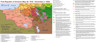
English: The First Republic of Armenia in 1918-1920. |
| Date | |
| Source | Own work |
| Author | Accipite7 |
Licensing
I, the copyright holder of this work, hereby publish it under the following license:
This file is licensed under the Creative Commons Attribution-Share Alike 4.0 International license.
- You are free:
- to share – to copy, distribute and transmit the work
- to remix – to adapt the work
- Under the following conditions:
- attribution – You must give appropriate credit, provide a link to the license, and indicate if changes were made. You may do so in any reasonable manner, but not in any way that suggests the licensor endorses you or your use.
- share alike – If you remix, transform, or build upon the material, you must distribute your contributions under the same or compatible license as the original.
File history
Click on a date/time to view the file as it appeared at that time.
| Date/Time | Thumbnail | Dimensions | User | Comment | |
|---|---|---|---|---|---|
| current | 15:13, 2 June 2021 | | 8,192 × 3,568 (14.85 MB) | Accipite7 | for the convenience of viewing small details, the size is increased, the colors are improved |
| 08:17, 25 May 2021 |  | 4,096 × 1,784 (3.69 MB) | Accipite7 | The border between Nahang of Shirak and Nahang of Syunik has been clarified. | |
| 09:59, 21 May 2021 |  | 4,096 × 1,784 (3.7 MB) | Accipite7 | The temporary border between the Republic of Armenia and the Soviet republics (August 10, 1920) in the Nakhichevan county has been clarified. Added a legend marked on the map under the number 26. | |
| 08:35, 13 May 2021 |  | 4,096 × 1,784 (3.97 MB) | Accipite7 | fixed typo | |
| 08:27, 13 May 2021 |  | 4,096 × 1,784 (3.97 MB) | Accipite7 | The names of the types of administrative units of the former Russian Empire have been clarified: uyezd = county, okrug = district, oblast = territory, guberniya = governorate. | |
| 11:14, 12 May 2021 |  | 4,096 × 1,784 (3.71 MB) | Accipite7 | Corrected data in the map legend regarding what is indicated on the map by numbers. Clarified the boundaries of the territories required at the Paris Peace Conference. I strongly ask the user of Culminatio not to vandalize and not return the map to the version on which he marked the line reached as a result of the Turkish offensive in 1920. Since, firstly, it is neural: Batumi, Artvin and Ardahan were under the control of the Democratic Republic of Georgia until February-March 1921. And secon... | |
| 04:13, 12 May 2021 |  | 5,375 × 2,341 (7.18 MB) | Culminatio | Reverted to version as of 15:05, 8 May 2021 (UTC) | |
| 07:11, 11 May 2021 |  | 4,096 × 1,784 (3.99 MB) | Accipite7 | The boundaries of the territory of the demands of the Armenian delegation in the Transcaucasus, submitted to the Paris Peace Conference of 1919, were clarified. There is no need to overload the map with the line reached by the Turkish forces in 1920, as the map already shows the results of the Armenian-Turkish war of 1920 - the border according to the Treaty of Alexandropol, December 2, 1920 | |
| 15:05, 8 May 2021 |  | 5,375 × 2,341 (7.18 MB) | Culminatio | Additional line of the turkish advance on the northern positions during the war of 1920. Additional numbers 10,19,20,21 on the map. | |
| 10:49, 8 May 2021 |  | 6,336 × 2,760 (2.21 MB) | Accipite7 | Improved colors. |
File usage
No pages on the English Wikipedia use this file (pages on other projects are not listed).
Global file usage
The following other wikis use this file:
- Usage on az.wikipedia.org
- Usage on be.wikipedia.org
- Usage on bg.wikipedia.org
- Usage on de.wikipedia.org
- Usage on el.wikipedia.org
- Usage on fi.wikipedia.org
- Usage on fr.wikipedia.org
- Usage on hy.wikipedia.org
- Usage on it.wikipedia.org
- Usage on nl.wikipedia.org
- Usage on pl.wikipedia.org
- Usage on pt.wikipedia.org
- Usage on ro.wikipedia.org
- Usage on ru.wikipedia.org
- Usage on sr.wikipedia.org
- Usage on uk.wikipedia.org
- Usage on zh.wikipedia.org