No higher resolution available.
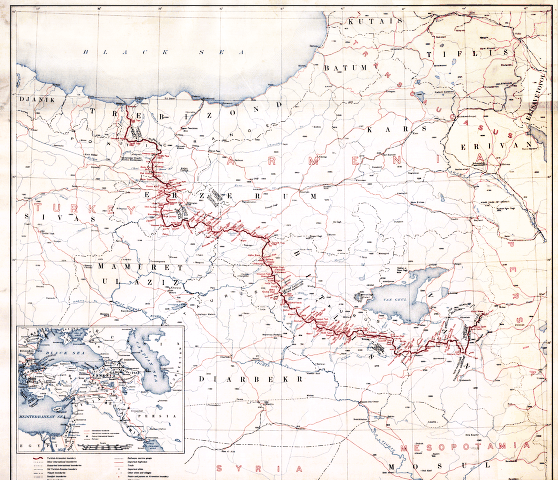
First_republic_of_Armenia-west_borders_by_Woodrow_Wilson.png (558 × 480 pixels, file size: 464 KB, MIME type: image/png)
| This is a file from the Wikimedia Commons. Information from its description page there is shown below. Commons is a freely licensed media file repository. You can help. |
Summary
American memory collection http://hdl.loc.gov/loc.gmd/g7431f.ct000197
hi-res file is available at File:Boundary between Turkey and Armenia as determined by Woodrow Wilson.jpg
Licensing
This image is in the public domain in the United States because it only contains materials that originally came from the United States Geological Survey, an agency of the United States Department of the Interior. For more information, see the official USGS copyright policy.
|
File history
Click on a date/time to view the file as it appeared at that time.
| Date/Time | Thumbnail | Dimensions | User | Comment | |
|---|---|---|---|---|---|
| current | 08:38, 4 November 2007 | | 558 × 480 (464 KB) | Rugby471 | shadow & stain |
| 07:37, 4 November 2007 |  | 558 × 480 (179 KB) | Rugby471 | color | |
| 22:00, 19 December 2006 |  | 558 × 480 (464 KB) | Electionworld | == Summary == American memory collection http://memory.loc.gov/cgi-bin/query/D?gmd:2:./temp/~ammem_He3o::@@@mdb=gmd,ww2map == Licensing == {{PD-USGov}} Category:Maps of the history of Armenia |
File usage
The following pages on the English Wikipedia use this file (pages on other projects are not listed):
Global file usage
The following other wikis use this file:
- Usage on ar.wikipedia.org
- Usage on arz.wikipedia.org
- Usage on ast.wikipedia.org
- Usage on bg.wikipedia.org
- Usage on ca.wikipedia.org
- Usage on de.wikipedia.org
- Usage on el.wikipedia.org
- Usage on es.wikipedia.org
- Usage on et.wikipedia.org
- Usage on fa.wikipedia.org
- Usage on fr.wikipedia.org
- Usage on he.wikipedia.org
- Usage on hr.wikipedia.org
- Usage on hy.wikipedia.org
- Usage on it.wikipedia.org
- Usage on ka.wikipedia.org
- Usage on lv.wikipedia.org
- Usage on pl.wikipedia.org
- Usage on pt.wikipedia.org
- Usage on ro.wikipedia.org
- Usage on ru.wikipedia.org
- Usage on ru.wikiversity.org
- Usage on sh.wikipedia.org
View more global usage of this file.