
Size of this preview: 800 × 421 pixels. Other resolutions: 320 × 169 pixels | 640 × 337 pixels | 1,024 × 539 pixels | 1,280 × 674 pixels | 2,400 × 1,264 pixels.
Original file (2,400 × 1,264 pixels, file size: 2.72 MB, MIME type: image/png)
| This is a file from the Wikimedia Commons. Information from its description page there is shown below. Commons is a freely licensed media file repository. You can help. |
Summary
| Description |
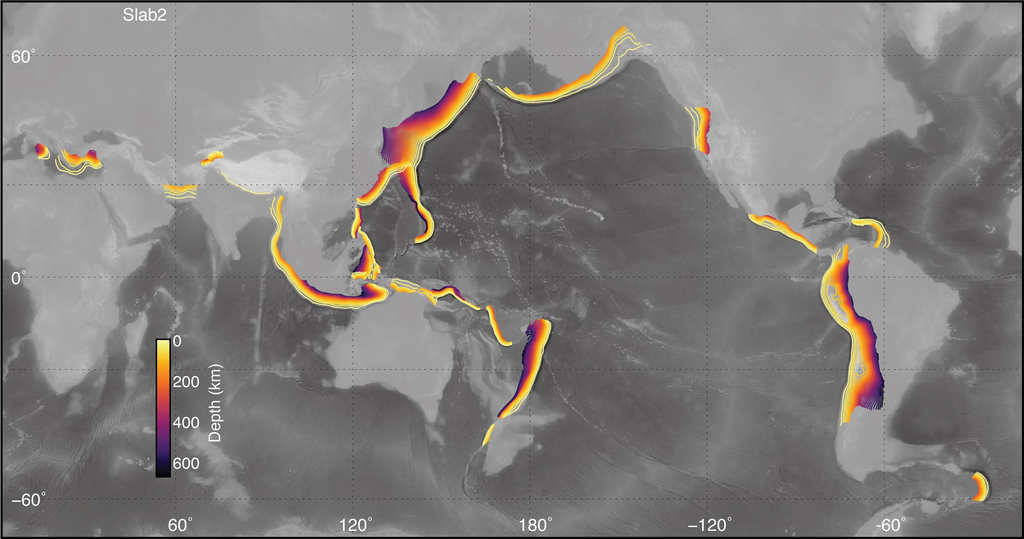
English: Map of subducted slabs, contoured by depth, for most active subduction zones around the globe. Map produced by Gavin P. Hayes (USGS). |
| Date | |
| Source | https://www.usgs.gov/media/images/global-distribution-models-included-slab2 |
| Author | Gavin P. Hayes |
Licensing
This image is in the public domain in the United States because it only contains materials that originally came from the United States Geological Survey, an agency of the United States Department of the Interior. For more information, see the official USGS copyright policy.
|
File history
Click on a date/time to view the file as it appeared at that time.
| Date/Time | Thumbnail | Dimensions | User | Comment | |
|---|---|---|---|---|---|
| current | 16:32, 13 March 2020 | | 2,400 × 1,264 (2.72 MB) | Mikenorton | Uploaded a work by Gavin P. Hayes from https://www.usgs.gov/media/images/global-distribution-models-included-slab2 with UploadWizard |
File usage
The following pages on the English Wikipedia use this file (pages on other projects are not listed):
Global file usage
The following other wikis use this file:
- Usage on af.wikipedia.org
- Usage on ban.wikipedia.org
- Usage on bn.wikipedia.org
- Usage on de.wikipedia.org
- Usage on es.wikipedia.org
- Usage on fr.wikipedia.org
- Usage on id.wikipedia.org
- Usage on it.wikipedia.org
- Usage on it.wikibooks.org
- Usage on it.wikiversity.org
- Usage on mk.wikipedia.org
- Usage on ru.wikipedia.org
- Usage on tl.wikipedia.org
- Usage on tr.wikipedia.org
- Usage on zh.wikipedia.org