
Size of this preview: 728 × 599 pixels. Other resolutions: 292 × 240 pixels | 583 × 480 pixels | 759 × 625 pixels.
Original file (759 × 625 pixels, file size: 201 KB, MIME type: image/jpeg)
| This is a file from the Wikimedia Commons. Information from its description page there is shown below. Commons is a freely licensed media file repository. You can help. |
Summary
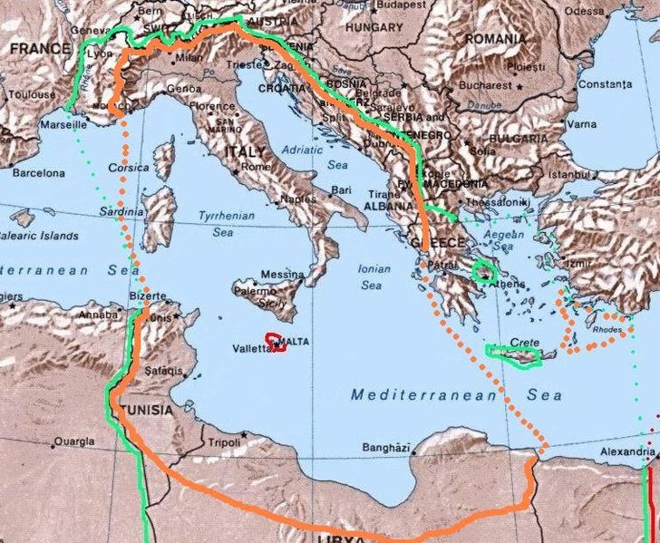
| Description | Map of the 1940 project "Imperial Italia", inside the orange line and dots, in Europe and North Africa. Self-made (I have based my work on the original Commons Image:Mediterranean Relief.jpg, licensed PD-USGov). The green line and dots show the biggest extension of Italian control in the Mediterranean sea in november 1942 (while the red shows the British controlled areas, like Malta). |
| Date | |
| Source | Own work |
| Author | Brunodambrosio |
| Other versions |
File:ItalianMareNostrum.jpg File:ProgettoImperoItaliano.jpg |
Licensing
| I, the copyright holder of this work, release this work into the public domain. This applies worldwide. In some countries this may not be legally possible; if so: I grant anyone the right to use this work for any purpose, without any conditions, unless such conditions are required by law. |
File history
Click on a date/time to view the file as it appeared at that time.
| Date/Time | Thumbnail | Dimensions | User | Comment | |
|---|---|---|---|---|---|
| current | 03:44, 19 April 2008 | | 759 × 625 (201 KB) | Brunodambrosio | {{Information |Description=Map of the 1940 project "Greater Italia", inside the orange line and dots, in Europe and North Africa. Self-made (I have based my work on the original Commons Image:Mediterranean Relief.jpg, licensed PD-USGov). The green line an |
File usage
The following pages on the English Wikipedia use this file (pages on other projects are not listed):
Global file usage
The following other wikis use this file:
- Usage on ar.wikipedia.org
- Usage on ast.wikipedia.org
- Usage on be.wikipedia.org
- Usage on ca.wikipedia.org
- Usage on eo.wikipedia.org
- Usage on es.wikipedia.org
- Usage on eu.wikipedia.org
- Usage on fa.wikipedia.org
- Usage on fi.wikipedia.org
- Usage on fr.wikipedia.org
- Usage on hu.wikipedia.org
- Usage on id.wikipedia.org
- Usage on it.wikipedia.org
- Usage on ka.wikipedia.org
- Usage on lt.wikipedia.org
- Usage on os.wikipedia.org
- Usage on pt.wikipedia.org
- Usage on ru.wikipedia.org
- Usage on sh.wikipedia.org
- Usage on sq.wikipedia.org
- Usage on sr.wikipedia.org
- Usage on sv.wikipedia.org
- Usage on uk.wikipedia.org