Size of this preview: 800 × 400 pixels. Other resolutions: 320 × 160 pixels | 640 × 320 pixels | 1,024 × 512 pixels | 1,280 × 640 pixels | 3,600 × 1,800 pixels.
Original file (3,600 × 1,800 pixels, file size: 2.84 MB, MIME type: image/png)
| This is a file from the Wikimedia Commons. Information from its description page there is shown below. Commons is a freely licensed media file repository. You can help. |
Summary
| Description |
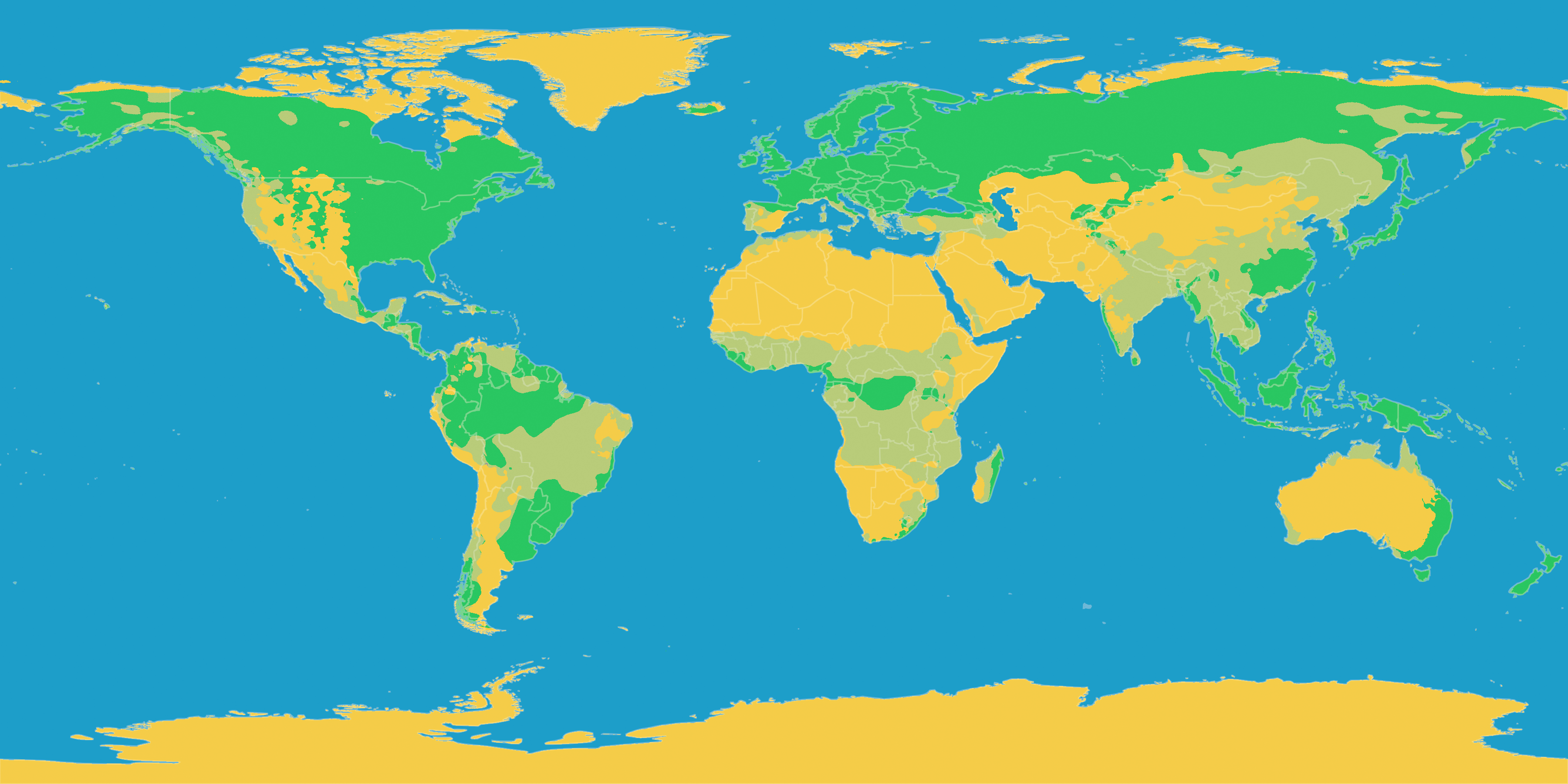
English: A map of Earth showing precipitation levels in different climates
Deutsch: Diese Karte stellt die Klimate der Erde nach ihrer Humidität dar.
Humides Klima
Teilarides Klima
Arides Klima |
| Date | |
| Source |
English: Own work based on the following paper. Deutsch: Selbst erstellt auf Basis dieser Geodaten:
|
| Author | LordToran |
| Permission (Reusing this file) |
|
| Other versions |
 |
Licensing
This file is licensed under the Creative Commons Attribution-Share Alike 3.0 Unported license.
- You are free:
- to share – to copy, distribute and transmit the work
- to remix – to adapt the work
- Under the following conditions:
- attribution – You must give appropriate credit, provide a link to the license, and indicate if changes were made. You may do so in any reasonable manner, but not in any way that suggests the licensor endorses you or your use.
- share alike – If you remix, transform, or build upon the material, you must distribute your contributions under the same or compatible license as the original.
File history
Click on a date/time to view the file as it appeared at that time.
| Date/Time | Thumbnail | Dimensions | User | Comment | |
|---|---|---|---|---|---|
| current | 14:26, 14 July 2020 | | 3,600 × 1,800 (2.84 MB) | Fährtenleser | Bessere Erkennbarkeit der Farbstufen für Farbsehschwache |
| 21:00, 11 October 2016 |  | 3,600 × 1,800 (828 KB) | Maphobbyist | The Kara Bogaz Lake was omitted. The Köppen system is based on the concept that climate types are correlated with the natural vegetation. | |
| 10:26, 22 June 2010 |  | 3,600 × 1,800 (659 KB) | Maphobbyist | Ther Caspian sea was total omitted. The Alps and central Norway are humid and not arid. The eastern part of Turkey is also semi arid. | |
| 20:55, 15 October 2007 |  | 3,600 × 1,800 (708 KB) | Lortordermur | == Beschreibung == {{Information |Description=Diese Karte stellt die Klimate der Erde nach ihrer Humidität dar. {{legend|#47bf47|Humides Klima}}{{legend|#bad54d|Teilarides Klima}}{{legend|#edc31d|Arides Klima}} |Source=Selbst erstellt auf Basis [http:/ |
File usage
No pages on the English Wikipedia use this file (pages on other projects are not listed).
Global file usage
The following other wikis use this file:
- Usage on ar.wikipedia.org
- Usage on da.wikipedia.org
- Usage on de.wikipedia.org
- Usage on eo.wikipedia.org
- Usage on es.wiktionary.org
- Usage on fi.wikipedia.org
- Usage on it.wikipedia.org
- Usage on it.wikibooks.org
- Usage on la.wikipedia.org
- Usage on lmo.wikipedia.org
- Usage on nap.wikipedia.org
- Usage on uk.wikipedia.org