Size of this preview: 783 × 600 pixels. Other resolutions: 313 × 240 pixels | 627 × 480 pixels | 1,002 × 768 pixels | 1,280 × 981 pixels | 2,610 × 2,000 pixels.
Original file (2,610 × 2,000 pixels, file size: 7.34 MB, MIME type: image/jpeg)
| This is a file from the Wikimedia Commons. Information from its description page there is shown below. Commons is a freely licensed media file repository. You can help. |
| This is a featured picture, which means that members of the community have identified it as one of the finest images on the English Wikipedia, adding significantly to its accompanying article. If you have a different image of similar quality, be sure to upload it using the proper free license tag, add it to a relevant article, and nominate it. |
| This image was selected as picture of the day on the English Wikipedia for February 24, 2019. |
Summary
| Description |
Nederlands: Kaart van Lancashire door Hondius, uitgave John Speed, vele raakvlakken met werk van Pieter v d Keere
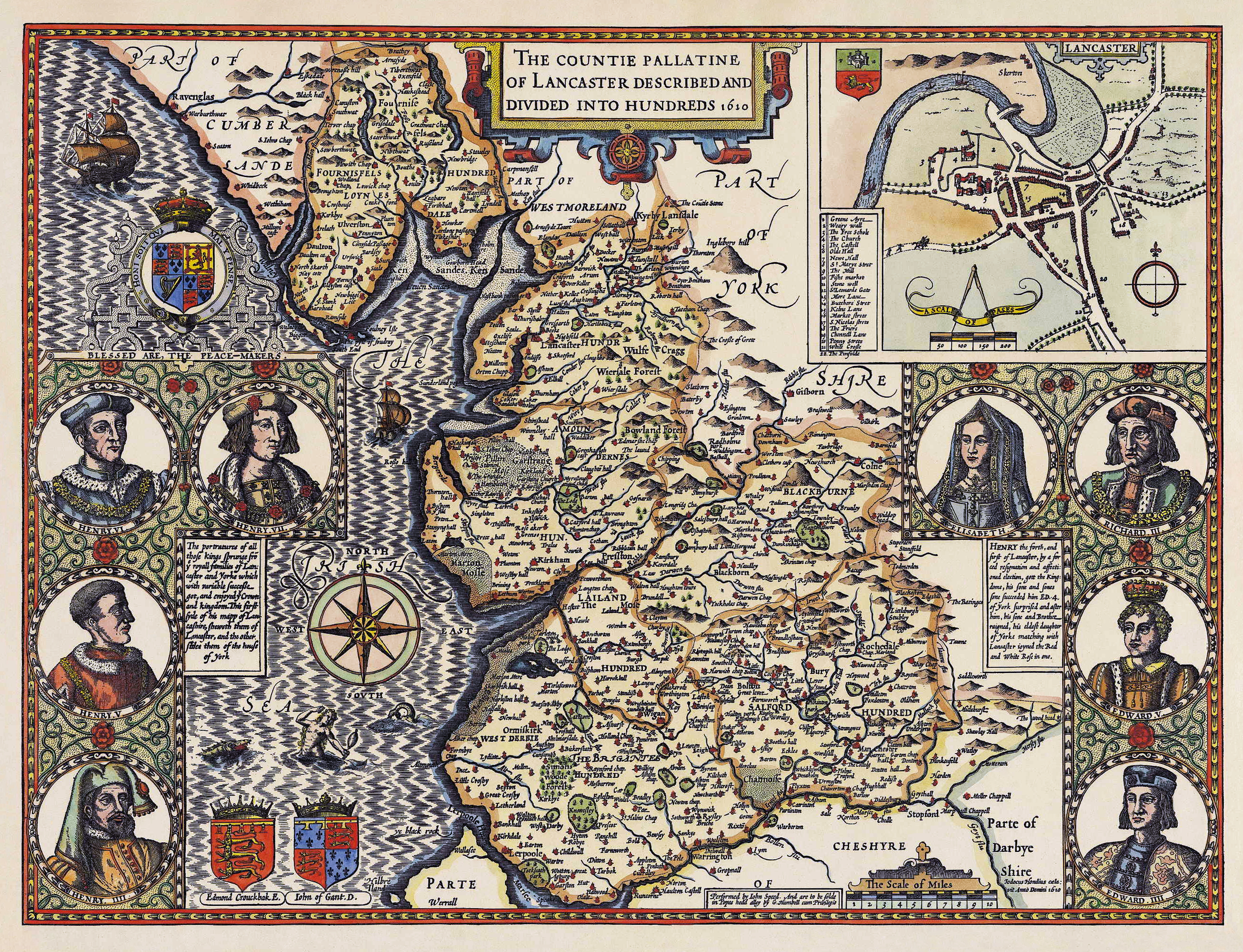
English: "The countie pallantine of Lancaster [a.k.a. Lancashire, England] described and divided into hundreds 1610" |
|||||||||
| Date | ||||||||||
| Source | Lancashire.gov.uk | |||||||||
| Creator |
Jodocus Hondius, engraved by John Speed, and restored by Adam Cuerden
|
|||||||||
| Geotemporal data | ||||||||||
| Bounding box |
|
|||||||||
| Georeferencing | ||||||||||
| Other versions |
|
|||||||||
|
Licensing
|
This work is in the public domain in its country of origin and other countries and areas where the copyright term is the author's life plus 100 years or fewer. | |
| This file has been identified as being free of known restrictions under copyright law, including all related and neighboring rights. | |
File history
Click on a date/time to view the file as it appeared at that time.
| Date/Time | Thumbnail | Dimensions | User | Comment | |
|---|---|---|---|---|---|
| current | 17:45, 20 October 2016 | | 2,610 × 2,000 (7.34 MB) | Adam Cuerden |
File usage
The following pages on the English Wikipedia use this file (pages on other projects are not listed):
- County palatine
- History of Lancashire
- John Speed
- Lancashire
- User:Adam Cuerden
- User:Amakuru/POTD 2
- User talk:Adam Cuerden/Archive 6
- Wikipedia:Featured picture candidates/Lancashire, 1610
- Wikipedia:Featured picture candidates/October-2016
- Wikipedia:Featured pictures/Diagrams, drawings, and maps/Maps
- Wikipedia:Featured pictures thumbs/59
- Wikipedia:Main Page history/2019 February 24
- Wikipedia:Picture of the day/February 2019
- Wikipedia:WikiCup/History/2016/Submissions/Adam Cuerden
- Wikipedia:WikiProject England/Recognized content
- Wikipedia:WikiProject Lancashire and Cumbria
- Wikipedia:WikiProject Lancashire and Cumbria/Recognised content
- Wikipedia:WikiProject UK geography
- Wikipedia:WikiProject UK geography/Announcements
- Wikipedia:Wikipedia Signpost/2016-11-26/Featured content
- Wikipedia:Wikipedia Signpost/Single/2016-11-26
- Wikipedia talk:WikiProject UK geography
- Template:POTD/2019-02-24
- Portal:Lancashire
Global file usage
The following other wikis use this file:
- Usage on ca.wikipedia.org
- Usage on de.wikipedia.org
- Usage on fr.wikipedia.org
- Usage on he.wikipedia.org
- Usage on lt.wikipedia.org
- Usage on nn.wikipedia.org
- Usage on pt.wikipedia.org
- Usage on ru.wikipedia.org
- Usage on uk.wikipedia.org