
Size of this preview: 589 × 599 pixels. Other resolutions: 236 × 240 pixels | 472 × 480 pixels | 755 × 768 pixels | 1,007 × 1,024 pixels | 2,003 × 2,037 pixels.
Original file (2,003 × 2,037 pixels, file size: 1.93 MB, MIME type: image/png)
| This is a file from the Wikimedia Commons. Information from its description page there is shown below. Commons is a freely licensed media file repository. You can help. |
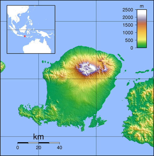
| Description | Topographic map of Lombok, Indonesia. Created with GMT from SRTM data |
| Date | (UTC) |
| Source | |
| Author |
|
| This is a retouched picture, which means that it has been digitally altered from its original version. Modifications: croped margins. The original can be viewed here: Lombok Topography.png:
|
I, the copyright holder of this work, hereby publish it under the following licenses:
This file is licensed under the Creative Commons Attribution-Share Alike 3.0 Unported, 2.5 Generic, 2.0 Generic and 1.0 Generic license.
- You are free:
- to share – to copy, distribute and transmit the work
- to remix – to adapt the work
- Under the following conditions:
- attribution – You must give appropriate credit, provide a link to the license, and indicate if changes were made. You may do so in any reasonable manner, but not in any way that suggests the licensor endorses you or your use.
- share alike – If you remix, transform, or build upon the material, you must distribute your contributions under the same or compatible license as the original.

|
Permission is granted to copy, distribute and/or modify this document under the terms of the GNU Free Documentation License, Version 1.2 or any later version published by the Free Software Foundation; with no Invariant Sections, no Front-Cover Texts, and no Back-Cover Texts. A copy of the license is included in the section entitled GNU Free Documentation License. |
You may select the license of your choice.
Original upload log
This image is a derivative work of the following images:
- File:Lombok_Topography.png licensed with Cc-by-sa-3.0,2.5,2.0,1.0, GFDL
- 2007-09-11T20:30:20Z Sadalmelik 2347x2135 (1833560 Bytes) {{Information |Description=Topographic map of Lombok, Indonesia. Created with GMT from SRTM data |Source=self-made |Date=Sep 11, 2007 |Author= [[User:Sadalmelik|Sadalmelik]] }} [[Category:Maps of Indonesia]] [[Category:Topog
Uploaded with derivativeFX
File history
Click on a date/time to view the file as it appeared at that time.
| Date/Time | Thumbnail | Dimensions | User | Comment | |
|---|---|---|---|---|---|
| current | 06:28, 12 February 2010 | | 2,003 × 2,037 (1.93 MB) | Elekhh | {{Information |Description=Topographic map of Lombok, Indonesia. Created with GMT from SRTM data |Source=*File:Lombok_Topography.png |Date=2010-02-12 06:26 (UTC) |Author=*File:Lombok_Topography.png: Sadalmelik *derivative w |
File usage
The following pages on the English Wikipedia use this file (pages on other projects are not listed):
- 5 August 2018 Lombok earthquake
- Babak River
- Bayan, Bayan, North Lombok
- Belanting
- Central Lombok Regency
- Dodokan River
- East Lombok Regency
- Gerung
- Jangkok River
- Kuta (Lombok)
- Labuhan Lombok
- List of national parks of Indonesia
- Lombok International Airport
- Mandalika (resort area)
- Mataram (city)
- Mount Rinjani
- Mount Rinjani National Park
- North Lombok Regency
- Pengenjek
- Praya, Lombok
- Selaparang Airport
- Selong
- Senggigi
- Tanak Tepong
- Tanjung, Lombok
- West Lombok Regency
- User:Ty654/List of earthquakes from 2015-2019 exceeding magnitude 6+
- Module:Location map/data/Indonesia Lombok
- Module:Location map/data/Indonesia Lombok/doc
Global file usage
The following other wikis use this file:
- Usage on ar.wikipedia.org
- Usage on ban.wikipedia.org
- Usage on ceb.wikipedia.org
- Usage on de.wikipedia.org
- Usage on es.wikipedia.org
- Usage on fa.wikipedia.org
- Usage on fr.wikipedia.org
- Usage on hu.wikipedia.org
- Usage on id.wikipedia.org
- Gunung Rinjani
- Daftar taman nasional di Indonesia
- Taman Nasional Gunung Rinjani
- Santosa Villas & Resort
- Templat:Location map Lombok Indonesia
- Gempa bumi Lombok 2013
- Gempa bumi Lombok Juli 2018
- Gempa bumi Lombok Agustus 2018
- Sungai Jangkok
- Bandar Udara Internasional Lombok
- Gunung Punikan
- Gunung Pengsong
- Usage on ja.wikipedia.org
- Usage on kn.wikipedia.org
- Usage on ko.wikipedia.org
- Usage on ml.wikipedia.org
- Usage on nl.wikipedia.org
View more global usage of this file.