
Size of this PNG preview of this SVG file: 690 × 599 pixels. Other resolutions: 276 × 240 pixels | 553 × 480 pixels | 884 × 768 pixels | 1,179 × 1,024 pixels | 2,358 × 2,048 pixels | 1,194 × 1,037 pixels.
Original file (SVG file, nominally 1,194 × 1,037 pixels, file size: 2.18 MB)
| This is a file from the Wikimedia Commons. Information from its description page there is shown below. Commons is a freely licensed media file repository. You can help. |
| Description |
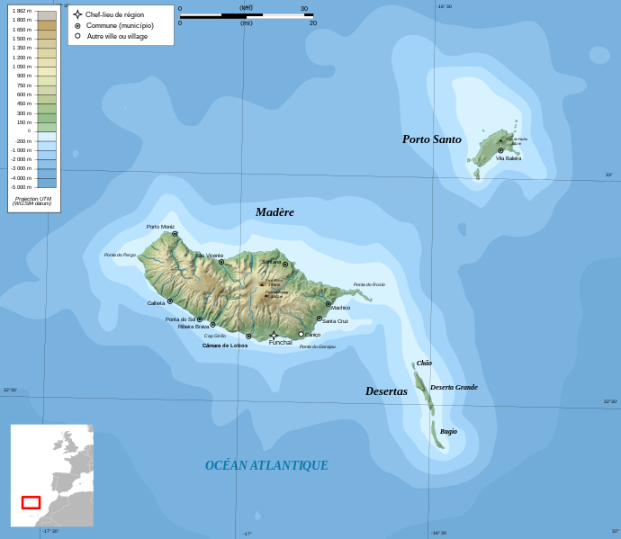
Français : Carte topographique en français de Madère Deutsch: Topographische Karte zum Madeira, in Französische English: Topographic and administrative map in French of Madeira Español: Mapa topográfico y administrativo en francès de Madeira Italiano: Carta topografica e amministrativa de Madera 日本語: フランス語で表示したマデイラ諸島の地形·行政地図 Português: Carta topográfica e da administração do Região Autónoma da Madeira em francês |
||
| Date | |||
| Source |
English: Own work ;
Français : Création personnelle ;
|
||
| Author | Bourrichon - fr:Bourrichon | ||
| Permission (Reusing this file) |
I, the copyright holder of this work, hereby publish it under the following licenses:
This file is licensed under the Creative Commons Attribution-Share Alike 3.0 Unported, 2.5 Generic, 2.0 Generic and 1.0 Generic license.
You may select the license of your choice. |
||
| Other versions |
File:Madeira topographic map-gl.svg File:Madeira topographic map-lt.svg File:Madeira topographic map-mk.svg |


|
This SVG file contains embedded text that can be translated into your language, using any capable SVG editor, text editor or the SVG Translate tool. For more information see: About translating SVG files. |
This W3C-unspecified vector image was created with Inkscape .
File history
Click on a date/time to view the file as it appeared at that time.
| Date/Time | Thumbnail | Dimensions | User | Comment | |
|---|---|---|---|---|---|
| current | 18:55, 5 November 2011 | | 1,194 × 1,037 (2.18 MB) | Bourrichon | recorrect scale |
| 18:52, 5 November 2011 |  | 1,194 × 1,037 (2.18 MB) | Bourrichon | correct scale | |
| 17:27, 3 May 2009 |  | 1,194 × 1,037 (2.18 MB) | Bourrichon | corr typo | |
| 17:21, 3 May 2009 |  | 1,194 × 1,037 (2.18 MB) | Bourrichon | corr key | |
| 17:11, 3 May 2009 |  | 1,194 × 1,037 (2.18 MB) | Bourrichon | {{Information |Description= {{fr|Carte topographique en français de fr:Madère}}{{de|Topographische Karte zum de:Madeira, in Französische}}{{en|Topographic and administrative map in French of en:Madeira}}{{es|Mapa topográfico y admin |
File usage
The following pages on the English Wikipedia use this file (pages on other projects are not listed):
Global file usage
The following other wikis use this file:
- Usage on ast.wikipedia.org
- Usage on bg.wikipedia.org
- Usage on cs.wikipedia.org
- Usage on de.wikipedia.org
- Usage on es.wikipedia.org
- Usage on fa.wikipedia.org
- Usage on fi.wikipedia.org
- Usage on fi.wikivoyage.org
- Usage on frr.wikipedia.org
- Usage on fr.wikipedia.org
- Usage on gl.wikipedia.org
- Usage on hu.wikipedia.org
- Usage on id.wikipedia.org
- Usage on is.wikipedia.org
- Usage on it.wikipedia.org
- Usage on ja.wikipedia.org
- Usage on jv.wikipedia.org
- Usage on la.wikipedia.org
- Usage on lb.wikipedia.org
- Usage on mg.wikipedia.org
- Usage on ms.wikipedia.org
- Usage on nl.wikipedia.org
- Usage on pl.wikipedia.org
- Usage on pt.wikipedia.org
- Usage on ro.wikipedia.org
- Usage on ru.wikipedia.org
- Usage on sc.wikipedia.org
- Usage on sk.wikipedia.org
- Usage on sl.wikipedia.org
View more global usage of this file.