No higher resolution available.
Mani_2000.png (380 × 450 pixels, file size: 147 KB, MIME type: image/png)
| This is a file from the Wikimedia Commons. Information from its description page there is shown below. Commons is a freely licensed media file repository. You can help. |
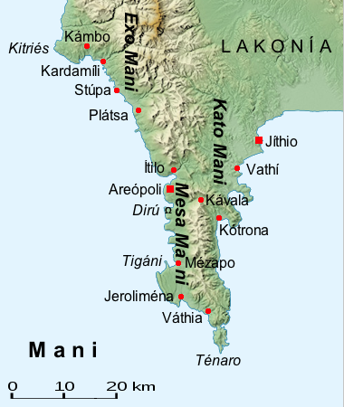
| Description | Map of the Mani (Greece, Peloponnes) | ||
| Date | |||
| Source | File:Peloponnese relief map-blank.svg | ||
| Author | al-Qamar | ||
| Permission (Reusing this file) |
|

File history
Click on a date/time to view the file as it appeared at that time.
| Date/Time | Thumbnail | Dimensions | User | Comment | |
|---|---|---|---|---|---|
| current | 20:35, 24 October 2014 | | 380 × 450 (147 KB) | Al-qamar | defekte Datei |
| 20:35, 24 October 2014 |  | 380 × 450 (147 KB) | Al-qamar | defekte Datei | |
| 20:28, 24 October 2014 |  | 380 × 450 (165 KB) | Al-qamar | {{Information |Description= Map of the Mani (Greece, Peloponnes) |Source= File:Peloponnese relief map-blank.svg |Date= 24.Oktober 2014 |Author= al-Qamar |Permission= {{GFDL}} |other_versions= }} Category:Maps of the Peloponnese |
File usage
The following pages on the English Wikipedia use this file (pages on other projects are not listed):
Global file usage
The following other wikis use this file:
- Usage on als.wikipedia.org
- Usage on ar.wikipedia.org
- Usage on ca.wikipedia.org
- Usage on da.wikipedia.org
- Usage on de.wikipedia.org
- Usage on el.wikipedia.org
- Usage on es.wikipedia.org
- Usage on hyw.wikipedia.org
- Usage on ja.wikipedia.org
- Usage on mk.wikipedia.org
- Usage on ro.wikipedia.org
- Usage on ru.wikipedia.org
- Usage on sr.wikipedia.org
- Usage on tr.wikipedia.org
- Usage on uk.wikipedia.org
- Usage on www.wikidata.org