
Size of this preview: 462 × 599 pixels. Other resolutions: 185 × 240 pixels | 620 × 804 pixels.
Original file (620 × 804 pixels, file size: 56 KB, MIME type: image/gif)
| This is a file from the Wikimedia Commons. Information from its description page there is shown below. Commons is a freely licensed media file repository. You can help. |
Summary
| Description |
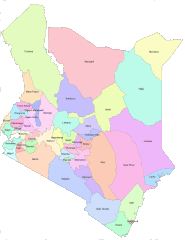
English: Areas that are covered by Counties in the new Kenya constitution |
| Date | |
| Source | https://opendata.go.ke/facet/counties |
| Author | Kenya Open Data Project |
Licensing

|
The copyright holder of this work allows anyone to use it for any purpose including unrestricted redistribution, commercial use, and modification.
Usage notes:
|
All the works in the Kenya open data website are free for use either commercially or non commercially as it is stated at the terms and conditions of the website. I believe that this is a non commercial use on commons.
File history
Click on a date/time to view the file as it appeared at that time.
| Date/Time | Thumbnail | Dimensions | User | Comment | |
|---|---|---|---|---|---|
| current | 06:48, 28 June 2012 | | 620 × 804 (56 KB) | Kagundu |
File usage
The following pages on the English Wikipedia use this file (pages on other projects are not listed):
Global file usage
The following other wikis use this file:
- Usage on ab.wikipedia.org
- Usage on ba.wikipedia.org
- Usage on bg.wikipedia.org
- Usage on bs.wikipedia.org
- Usage on cs.wikipedia.org
- Usage on cy.wikipedia.org
- Usage on eo.wikipedia.org
- Usage on et.wikipedia.org
- Usage on eu.wikipedia.org
- Usage on fa.wikipedia.org
- Usage on fi.wikipedia.org
- Usage on fr.wikipedia.org
- Usage on he.wikipedia.org
- Usage on hu.wikipedia.org
- Usage on id.wikipedia.org
- Usage on incubator.wikimedia.org
- Usage on it.wikipedia.org
- Usage on ko.wikipedia.org
- Usage on ku.wikipedia.org
- Usage on my.wikipedia.org
- Usage on pl.wikipedia.org
- Usage on ru.wikipedia.org
- Кения
- Ньянза
- Западная провинция (Кения)
- Рифт-Валли
- Северо-Восточная провинция (Кения)
- Центральная провинция (Кения)
- Прибрежная провинция (Кения)
- Восточная провинция (Кения)
- Бусиа (округ, Кения)
- Найроби (провинция Кении)
- Административное деление Кении
- Гарисса (округ)
- Нарок (округ)
- Ваджир (округ)
- Шаблон:Административное деление Кении
- Занзойский округ
- Вихига (округ)
- Западный покотский округ
- Исиоло (округ)
- Баринго (округ)
- Ньери (округ)
- Ньяндаруа (округ)
- Бомет (округ)
- Бунгома (округ)
- Элгейо-Мараквет (округ)
View more global usage of this file.