
Size of this PNG preview of this SVG file: 437 × 599 pixels. Other resolutions: 175 × 240 pixels | 350 × 480 pixels | 560 × 768 pixels | 747 × 1,024 pixels | 1,493 × 2,048 pixels | 657 × 901 pixels.
Original file (SVG file, nominally 657 × 901 pixels, file size: 316 KB)
| This is a file from the Wikimedia Commons. Information from its description page there is shown below. Commons is a freely licensed media file repository. You can help. |
Summary
| Description |
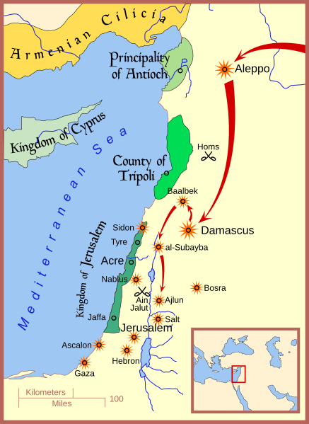
English: A map showing Mongol movements and targets in the year 1260 in the Levant (Palestine and Syria). Mercator projection. |
| Date | |
| Source | Own work |
| Author | Map Master |
| Permission (Reusing this file) |
I, the copyright holder of this work, hereby publish it under the following license: This file is licensed under the Creative Commons Attribution 3.0 Unported license.
|
| Other versions |
[]
|
| SVG development | This symbol was created with Inkscape…important. This symbol uses embedded text that can be easily translated using a text editor. |


References
For the list of cities besieged and raided, which are denoted by the orange sunburst symbol, I have relied primarily on the following references:
- Amitai-Preiss, Reuven (1995) Mongols and Mamluks: The Mamluk-Ilkhanid War, 1260-1281, Combridge University Press, Cambridge ISBN: 978-0521462266.
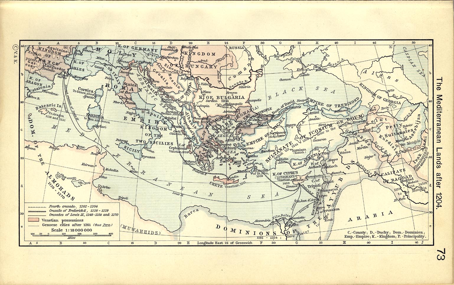
The borders of the rump Kingdom of Jerusalem, Principality of Antioch, and the County of Tripoli are taken from:
- Sheperd, William R. (1911) "Mediterranean Lands after 1204" in Historical Atlas, Category:New York: Henry Holt and Company, p. 73 OCLC: 894215541.
Licensing
I, the copyright holder of this work, hereby publish it under the following license:
This file is licensed under the Creative Commons Attribution 3.0 Unported license.
- You are free:
- to share – to copy, distribute and transmit the work
- to remix – to adapt the work
- Under the following conditions:
- attribution – You must give appropriate credit, provide a link to the license, and indicate if changes were made. You may do so in any reasonable manner, but not in any way that suggests the licensor endorses you or your use.
File history
Click on a date/time to view the file as it appeared at that time.
| Date/Time | Thumbnail | Dimensions | User | Comment | |
|---|---|---|---|---|---|
| current | 13:46, 24 March 2021 | | 657 × 901 (316 KB) | Dimash Kenesbek | Reverted to version as of 17:09, 19 June 2008 (UTC) |
| 13:44, 24 March 2021 |  | 657 × 901 (342 KB) | Dimash Kenesbek | File uploaded using svgtranslate tool (https://svgtranslate.toolforge.org/). Added translation for kk-cyrl. | |
| 13:43, 24 March 2021 |  | 657 × 901 (330 KB) | Dimash Kenesbek | File uploaded using svgtranslate tool (https://svgtranslate.toolforge.org/). Added translation for kk-cyrl. | |
| 17:09, 19 June 2008 |  | 657 × 901 (316 KB) | MapMaster | small fixes and improvements | |
| 16:22, 19 June 2008 |  | 657 × 901 (287 KB) | MapMaster | Adjusted area for Kingdom of Jerusalem, added Jaffa | |
| 16:05, 13 June 2008 |  | 657 × 901 (284 KB) | MapMaster | added Sidon | |
| 02:38, 12 June 2008 |  | 657 × 901 (277 KB) | MapMaster | minor edits | |
| 02:11, 11 June 2008 |  | 657 × 901 (276 KB) | MapMaster |
File usage
The following pages on the English Wikipedia use this file (pages on other projects are not listed):
Global file usage
The following other wikis use this file:
- Usage on af.wikipedia.org
- Usage on arz.wikipedia.org
- Usage on azb.wikipedia.org
- Usage on az.wikipedia.org
- Usage on be.wikipedia.org
- Usage on bg.wikipedia.org
- Usage on bn.wikipedia.org
- Usage on ca.wikipedia.org
- Usage on da.wikipedia.org
- Usage on eo.wikipedia.org
- Usage on et.wikipedia.org
- Usage on fa.wikipedia.org
- Usage on fi.wikipedia.org
- Usage on fr.wikipedia.org
- Usage on he.wikipedia.org
- Usage on id.wikipedia.org
- Usage on ja.wikipedia.org
- Usage on ka.wikipedia.org
- Usage on mk.wikipedia.org
- Usage on ms.wikipedia.org
- Usage on pl.wikipedia.org
- Usage on ro.wikipedia.org
- Usage on sr.wikipedia.org
- Usage on sv.wikipedia.org
- Usage on tr.wikipedia.org
- Usage on uk.wikipedia.org
- Usage on uz.wikipedia.org
- Usage on www.wikidata.org
- Usage on zh.wikipedia.org