
Size of this PNG preview of this SVG file: 474 × 600 pixels. Other resolutions: 190 × 240 pixels | 379 × 480 pixels | 607 × 768 pixels | 809 × 1,024 pixels | 1,619 × 2,048 pixels | 1,380 × 1,746 pixels.
Original file (SVG file, nominally 1,380 × 1,746 pixels, file size: 1.82 MB)
| This is a file from the Wikimedia Commons. Information from its description page there is shown below. Commons is a freely licensed media file repository. You can help. |
Summary
| Description |
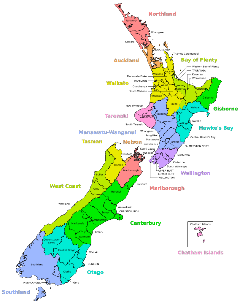
English: Map of the Territorial Authorities of New Zealand overlayed with Regional Council areas, including the Chatham Islands in an inset.
Territorial Authorities, Regional Councils and text labels are in three separate layers. Map created with GIS data from StatsNZ [1] (Retrieved March 2017). |
| Date | |
| Source | Own work |
| Author | Korakys |
| Other versions |
|

Licensing
I, the copyright holder of this work, hereby publish it under the following license:
This file is licensed under the Creative Commons Attribution-Share Alike 4.0 International license.
- You are free:
- to share – to copy, distribute and transmit the work
- to remix – to adapt the work
- Under the following conditions:
- attribution – You must give appropriate credit, provide a link to the license, and indicate if changes were made. You may do so in any reasonable manner, but not in any way that suggests the licensor endorses you or your use.
- share alike – If you remix, transform, or build upon the material, you must distribute your contributions under the same or compatible license as the original.
File history
Click on a date/time to view the file as it appeared at that time.
| Date/Time | Thumbnail | Dimensions | User | Comment | |
|---|---|---|---|---|---|
| current | 10:12, 14 March 2017 | | 1,380 × 1,746 (1.82 MB) | Korakys | Corrected two labels. Converted text to paths. |
| 03:30, 10 March 2017 |  | 1,380 × 1,746 (1.38 MB) | Korakys | Added labels. | |
| 00:23, 10 March 2017 |  | 1,207 × 1,746 (1.3 MB) | Korakys | User created page with UploadWizard |
File usage
The following pages on the English Wikipedia use this file (pages on other projects are not listed):
Global file usage
The following other wikis use this file:
- Usage on af.wikipedia.org
- Usage on ary.wikipedia.org
- Usage on cs.wikipedia.org
- Usage on de.wikipedia.org
- Usage on fr.wikipedia.org
- Usage on he.wikipedia.org
- Usage on hi.wikipedia.org
- Usage on hu.wikipedia.org
- Usage on sl.wikipedia.org
- Usage on tr.wikipedia.org
- Usage on uk.wikipedia.org