Size of this preview: 800 × 480 pixels. Other resolutions: 320 × 192 pixels | 1,024 × 614 pixels | 1,280 × 768 pixels | 3,000 × 1,800 pixels.
Original file (3,000 × 1,800 pixels, file size: 577 KB, MIME type: image/png)
| This is a file from the Wikimedia Commons. Information from its description page there is shown below. Commons is a freely licensed media file repository. You can help. |
Summary

|
This locator map image could be re-created using vector graphics as an SVG file. This has several advantages; see Commons:Media for cleanup for more information. If an SVG form of this image is available, please upload it and afterwards replace this template with
{{vector version available|new image name}}.
It is recommended to name the SVG file “Non-Self-Governing.svg”—then the template Vector version available (or Vva) does not need the new image name parameter. |
| Description |
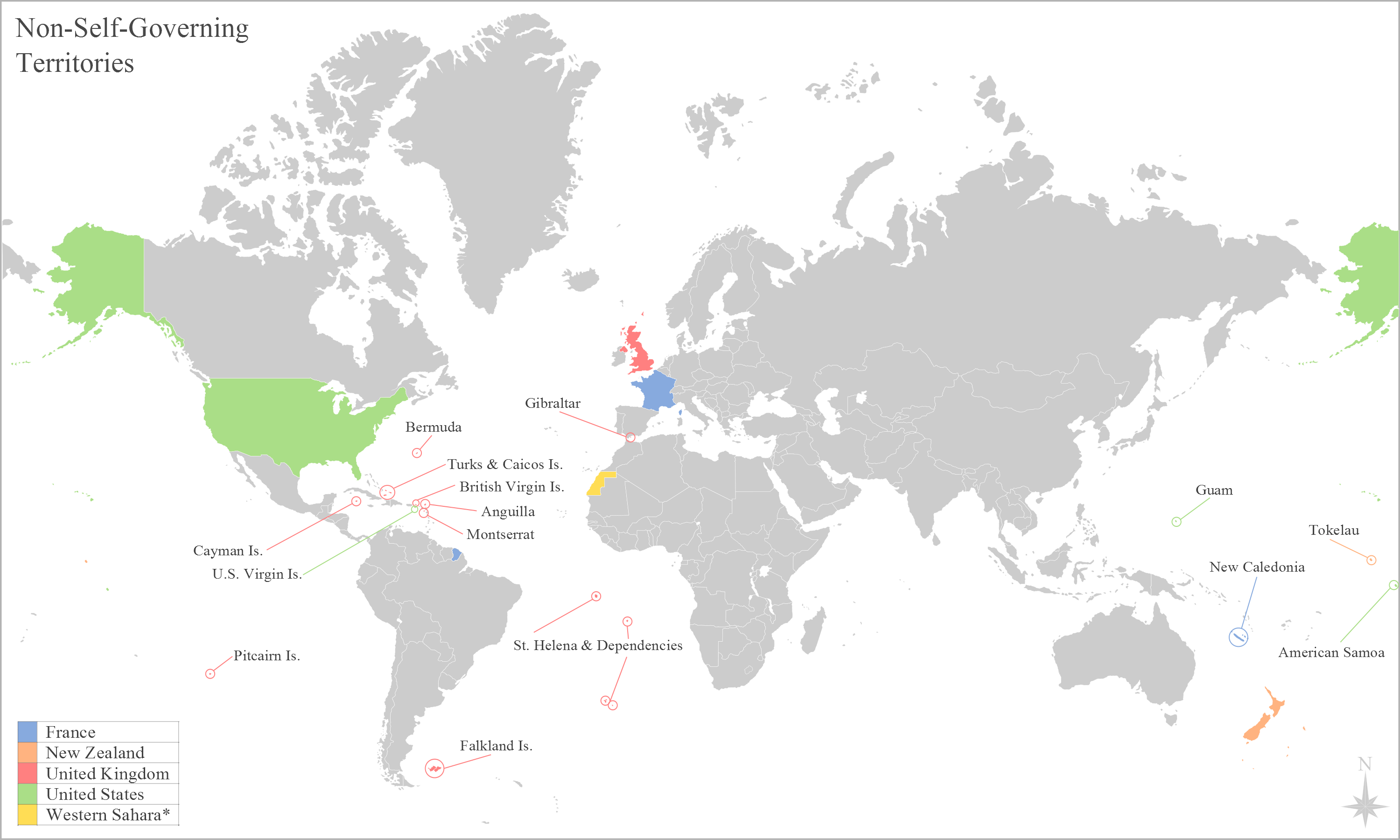
English: United Nations list of non-self-governing territories. |
| Date | |
| Source | Own work |
| Author | George Bosanko |
Licensing
I, the copyright holder of this work, hereby publish it under the following license:
This file is licensed under the Creative Commons Attribution-Share Alike 3.0 Unported license.
- You are free:
- to share – to copy, distribute and transmit the work
- to remix – to adapt the work
- Under the following conditions:
- attribution – You must give appropriate credit, provide a link to the license, and indicate if changes were made. You may do so in any reasonable manner, but not in any way that suggests the licensor endorses you or your use.
- share alike – If you remix, transform, or build upon the material, you must distribute your contributions under the same or compatible license as the original.
File history
Click on a date/time to view the file as it appeared at that time.
| Date/Time | Thumbnail | Dimensions | User | Comment | |
|---|---|---|---|---|---|
| current | 17:46, 19 January 2015 | | 3,000 × 1,800 (577 KB) | Legoless | including French Guiana as part of the Republic |
| 06:44, 24 October 2012 |  | 3,000 × 1,800 (457 KB) | Nicolay Sidorov | Remove Kosovo border. If you want Kosovo, please paint borders of other limited recogn. countries too(Abkhazia, S.Ossetia and N.Cyprus) | |
| 15:09, 6 June 2012 |  | 3,000 × 1,800 (530 KB) | GBozanko | Release of Rwanda and Burundi | |
| 15:06, 6 June 2012 |  | 3,000 × 1,800 (530 KB) | GBozanko | Removal of colonial borders from previous edit. Colouring of Alaska and Hawaii on east of map. | |
| 15:06, 6 June 2012 |  | 3,000 × 1,800 (530 KB) | GBozanko | Removal of colonial borders from previous edit. Colouring of Alaska and Hawaii on east of map. | |
| 11:54, 1 June 2012 |  | 3,000 × 1,800 (582 KB) | GBozanko | spelling | |
| 21:15, 29 May 2012 |  | 3,000 × 1,800 (589 KB) | GBozanko | fix | |
| 20:56, 29 May 2012 |  | 3,000 × 1,800 (589 KB) | GBozanko |
File usage
The following pages on the English Wikipedia use this file (pages on other projects are not listed):
Global file usage
The following other wikis use this file:
- Usage on azb.wikipedia.org
- Usage on es.wikipedia.org
- Usage on et.wikipedia.org
- Usage on fi.wikipedia.org
- Usage on mk.wikipedia.org
- Usage on pt.wikipedia.org
- Usage on sd.wikipedia.org
- Usage on sq.wikipedia.org
- Usage on sr.wikipedia.org
- Usage on zh.wikipedia.org