
No higher resolution available.
Nord_du_Maroc,_carte_ethno-linguistique.PNG (630 × 509 pixels, file size: 43 KB, MIME type: image/png)
| This is a file from the Wikimedia Commons. Information from its description page there is shown below. Commons is a freely licensed media file repository. You can help. |
Summary
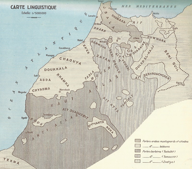
| Description |
English: Ethno-linguistic map of northern Morocco -own made-
Français : Carte ethno-linguistique du nord du Maroc -création personnelle- Sources: -"La frontera entre el bereber y el árabe en el Rif" & "Materialien für einen Dialektatlas von Nordost-Marokko", de P. Behnstedt -"Carte des tribus des Jbala (et des Rifains)", de A. Amahane & J. Vignet-Zunz -Carte linguistique du Maroc, de G. S. Colin Légende: i. Oudayas (Guich de Rabat) ; ii. Mejjat (Guich de Meknès) ; iii. Hejaoua ; iv. Oulad Aïssa ; v. Oulad el-Haj Saïs (Guich de Fès) ; vi. Chrardas (Guich de Fès) ; vii. Oudayas (Guich de Fès) ; viii. Arab Saïs (Guich de Fès) ; ix. Hamiane (Guich de Fès) ; x. Lemta ; xi. Oulad el-Haj el-Oued (Guich de Fès) ; xii. Behalil ; xiii. Tribus du Pachalik de Sefrou (Kechtala-Aït Youssi) ; xiv. Sejâ (Guich de Fès) ; xv. Aït Youb ; xvi. Marmoucha ; xvii. Aït Seghrouchen ; xviii. Aït Sadden ; xix. Yazgha ; xx. Aït Ayache ; xxi. Meknassa ; xxii. Maghraoua ; xxiii. Beni Oukil ; xxiv. Sejâ ; xxv. Rwabâ ; xxvi. Haddyin ; xxvii. Mehaya ; xxviii. Aït Morghi ; xxix. Oulad Khaoua ; xxx. Oulad Sidi Belkacem |
| Date | |
| Source | Own work |
| Author | Omar-toons |
Licensing
I, the copyright holder of this work, hereby publish it under the following license:
This file is licensed under the Creative Commons Attribution-Share Alike 4.0 International license.
- You are free:
- to share – to copy, distribute and transmit the work
- to remix – to adapt the work
- Under the following conditions:
- attribution – You must give appropriate credit, provide a link to the license, and indicate if changes were made. You may do so in any reasonable manner, but not in any way that suggests the licensor endorses you or your use.
- share alike – If you remix, transform, or build upon the material, you must distribute your contributions under the same or compatible license as the original.
File history
Click on a date/time to view the file as it appeared at that time.
| Date/Time | Thumbnail | Dimensions | User | Comment | |
|---|---|---|---|---|---|
| current | 18:43, 12 April 2020 | | 630 × 509 (43 KB) | Omar-toons | Adjust Targuist, Aït Gmil, Aït Boufrah & Aït Itteft partly Berber-speaking areas acc. to Lafkioui |
| 17:24, 22 June 2016 |  | 630 × 509 (43 KB) | Omar-toons | Corr. Zerhoun, Triffa & Srayr | |
| 06:10, 6 May 2015 |  | 630 × 509 (37 KB) | Omar-toons | min. ch. on Sanhaja d-Srayr acc. to Lafkioui: Berberophones remain among Ketamas, Riffian for N.E. Mezdouy | |
| 01:05, 28 April 2015 |  | 630 × 509 (37 KB) | Omar-toons | min. ch. | |
| 03:20, 2 April 2015 |  | 630 × 509 (37 KB) | Omar-toons | min. ch. | |
| 08:41, 23 March 2015 |  | 630 × 509 (37 KB) | Omar-toons | User created page with UploadWizard |
File usage
The following pages on the English Wikipedia use this file (pages on other projects are not listed):
Global file usage
The following other wikis use this file:
- Usage on ary.wikipedia.org
- Usage on es.wikipedia.org
- Usage on fa.wikipedia.org
- Usage on fr.wikipedia.org
- Usage on id.wikipedia.org
- Usage on it.wikipedia.org
- Usage on ur.wikipedia.org
- Usage on vi.wikipedia.org