Size of this preview: 552 × 600 pixels. Other resolutions: 221 × 240 pixels | 442 × 480 pixels | 707 × 768 pixels | 943 × 1,024 pixels | 1,885 × 2,048 pixels | 4,455 × 4,840 pixels.
Original file (4,455 × 4,840 pixels, file size: 2.1 MB, MIME type: image/png)
| This is a file from the Wikimedia Commons. Information from its description page there is shown below. Commons is a freely licensed media file repository. You can help. |
Summary
| Description |
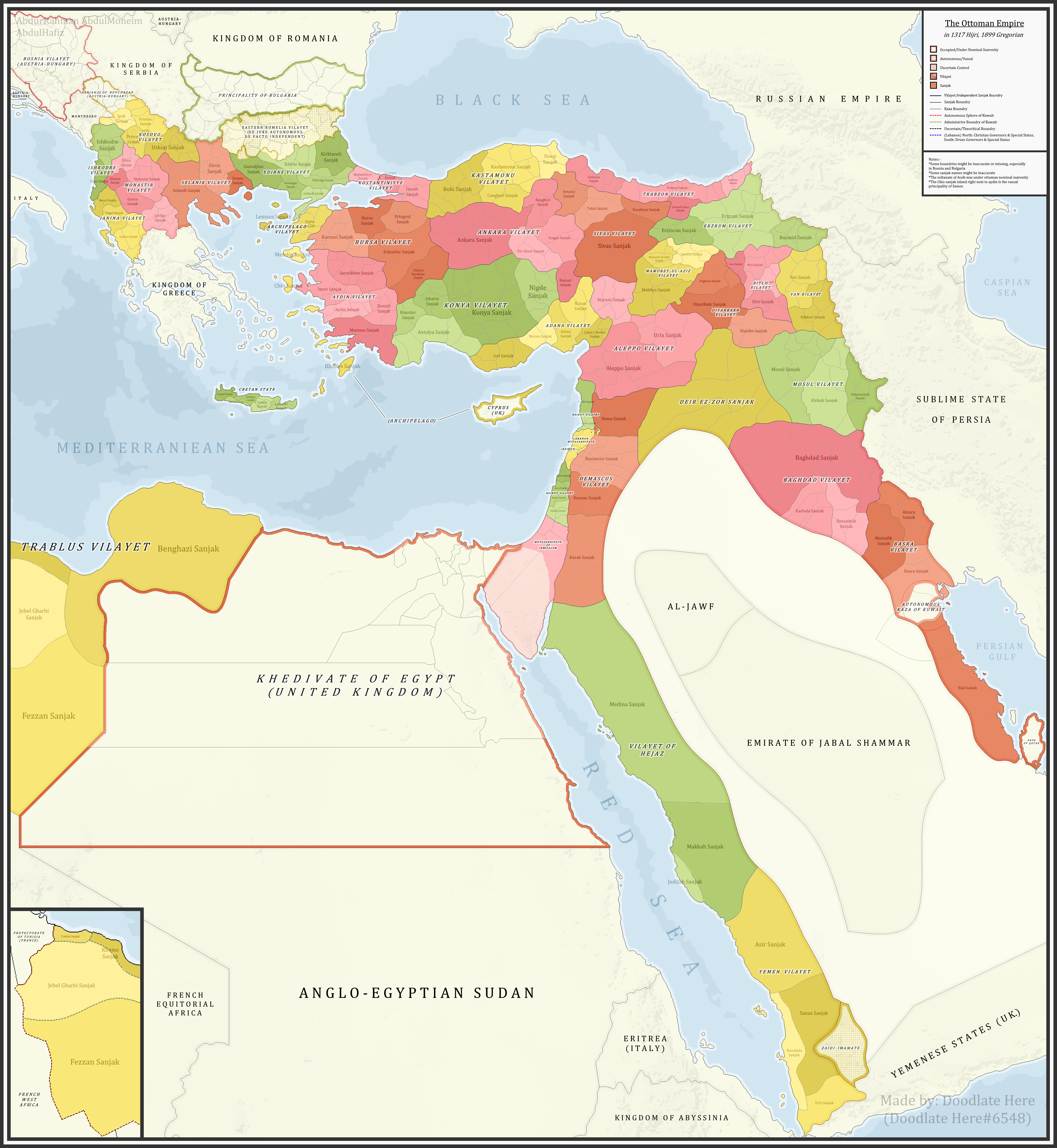
English: A detailed map showing the Ottoman Empire and its dependencies, including its administrative divisions, in 1899 CE (1317 Hijri). |
| Date | |
| Source |
Own work References:The sources that back up the maps are as follows: [1] Pavet de Courteille, Abel (1876). État présent de l'empire ottoman (in French). J. Dumaine. pp. 91–96. (for Yemen) [2] http://tarihvemedeniyet.org/2009/10/trablus-garb-vilayeti.html for Tripolitania [3] http://tarihvemedeniyet.org/2009/10/bosna-vilayeti.html for Bosnia [4] https://www.nsi.bg/nrnm/index.php?i=1&ezik=en for eastern Rumelia [5] http://hdl.loc.gov/loc.gmd/g7431f.ct002181 (Rest of Ottoman subdivisions, taken from the United States Library of Congress's Geography & Map Division, digital ID g7431f.ct002181) |
| Author | AbdurRahman AbdulMoneim |
Licensing
I, the copyright holder of this work, hereby publish it under the following license:
This file is licensed under the Creative Commons Attribution-Share Alike 4.0 International license.
- You are free:
- to share – to copy, distribute and transmit the work
- to remix – to adapt the work
- Under the following conditions:
- attribution – You must give appropriate credit, provide a link to the license, and indicate if changes were made. You may do so in any reasonable manner, but not in any way that suggests the licensor endorses you or your use.
- share alike – If you remix, transform, or build upon the material, you must distribute your contributions under the same or compatible license as the original.
| Annotations | This image is annotated: View the annotations at Commons |
File history
Click on a date/time to view the file as it appeared at that time.
| Date/Time | Thumbnail | Dimensions | User | Comment | |
|---|---|---|---|---|---|
| current | 07:16, 16 November 2021 | | 4,455 × 4,840 (2.1 MB) | BasilLeaf | updates |
| 19:22, 5 May 2021 |  | 4,455 × 4,840 (2.11 MB) | Super Dromaeosaurus | Romanian Black Sea Snake Island, Romanian-Russian border at Dobruja-Bessarabia, removed lands in Banat that didn't belong to Romania then | |
| 18:17, 14 April 2021 |  | 4,455 × 4,840 (2.03 MB) | محمد٢ | Reverted to version as of 18:40, 19 January 2021 (UTC) | |
| 02:05, 8 February 2021 |  | 4,455 × 4,840 (2.1 MB) | BasilLeaf | Minor name fixes. Iran's official English name was "Sublime State of Persia". "Arab Gulf" Doesn't exist. There's "Arabian Gulf", a name that only came to decently widespread usage from 1960s. Contemporary internationally accepted term is "Persian Gulf". | |
| 18:40, 19 January 2021 |  | 4,455 × 4,840 (2.03 MB) | Userd898 | minor edit regarding the recoloring of a wrongly colored spot in haasa | |
| 18:05, 19 January 2021 |  | 4,455 × 4,840 (2.03 MB) | Userd898 | fixed some mistakes in yemen and labeled qatar as occupied source: https://www.euratlas.net/history/hisatlas/arabia/1904__AR.html | |
| 18:48, 14 January 2021 |  | 4,455 × 4,840 (2.1 MB) | BasilLeaf | Minor name fixes. Iran's official English name was "Sublime State of Persia". "Arab Gulf" Doesn't exist. There's "Arabian Gulf", a name that only came to decently widespread usage in 1960s. | |
| 19:15, 27 December 2020 |  | 4,455 × 4,840 (2.03 MB) | Userd898 | Uploaded own work with UploadWizard |
File usage
The following pages on the English Wikipedia use this file (pages on other projects are not listed):
- Abdul Hamid II
- Administrative divisions of the Ottoman Empire
- Baghdad vilayet
- Basra vilayet
- Beirut vilayet
- Hejaz vilayet
- Janina vilayet
- Kosovo vilayet
- Mosul vilayet
- Mount Lebanon Mutasarrifate
- Ottoman Empire
- Ottoman Iraq
- Ottoman Syria
- Ottoman Tripolitania
- Sanjak
- Scutari vilayet
- Syria vilayet
- Talk:Greater Palestine
- User:Falcaorib
Global file usage
The following other wikis use this file:
- Usage on bg.wikipedia.org
- Usage on bn.wikipedia.org
- Usage on ca.wikipedia.org
- Usage on ckb.wikipedia.org
- Usage on de.wikipedia.org
- Usage on el.wikipedia.org
- Usage on es.wikipedia.org
- Usage on fa.wikipedia.org
- Usage on fi.wikipedia.org
- Usage on fr.wikipedia.org
- Usage on gl.wikipedia.org
- Usage on he.wikipedia.org
- Usage on it.wikipedia.org
- Usage on ja.wikipedia.org
- Usage on ku.wikipedia.org
- Usage on lt.wikipedia.org
- Usage on mk.wikipedia.org
- Usage on mt.wikipedia.org
- Usage on ru.wikipedia.org
- Usage on sl.wikipedia.org
- Usage on sq.wikipedia.org
- Usage on th.wikipedia.org
- Usage on tr.wikipedia.org