
Size of this PNG preview of this SVG file: 648 × 599 pixels. Other resolutions: 260 × 240 pixels | 519 × 480 pixels | 831 × 768 pixels | 1,108 × 1,024 pixels | 2,215 × 2,048 pixels | 1,060 × 980 pixels.
Original file (SVG file, nominally 1,060 × 980 pixels, file size: 472 KB)
| This is a file from the Wikimedia Commons. Information from its description page there is shown below. Commons is a freely licensed media file repository. You can help. |

|
This SVG file contains embedded text that can be translated into your language, using any capable SVG editor, text editor or the SVG Translate tool. For more information see: About translating SVG files. |
Summary
| Description |
[]
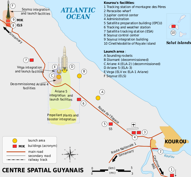
Català: Mapa de la infraestructura dels llançadors Ariane i Vega al port espacial europeu (Centre Spatial Guyanais o CSG), Kourou, Guaiana Francesa Deutsch: Karte der Infrastruktur der Ariana- und Vega-Startrampen auf dem Weltraumbahnhof Kourou, Französisch-Guayana English: Map of the infrastructure for the Ariane and Vega launchers at the Europe's Spaceport (Centre Spatial Guyanais or CSG) , Kourou, French Guiana Français : Carte des installations du Centre Spatial Guyanais (CSG) de Kourou, Guyane Francaise (France) Magyar: A Guyanai Űrközpont térképe Nederlands: Kaart van de Europese lanceerbasis (Centre Spatial Guyanais of CSG) in Kourou, Frans Guiana Русский: План космодрома «Куру» во Французской Гвиане |
||
| Date | |||
| Source | Own work | ||
| Author | Pline | ||
| Other versions |
[]
|


Licensing
I, the copyright holder of this work, hereby publish it under the following licenses:

|
Permission is granted to copy, distribute and/or modify this document under the terms of the GNU Free Documentation License, Version 1.2 or any later version published by the Free Software Foundation; with no Invariant Sections, no Front-Cover Texts, and no Back-Cover Texts. A copy of the license is included in the section entitled GNU Free Documentation License. |
This file is licensed under the Creative Commons Attribution-Share Alike 3.0 Unported, 2.5 Generic, 2.0 Generic and 1.0 Generic license.
- You are free:
- to share – to copy, distribute and transmit the work
- to remix – to adapt the work
- Under the following conditions:
- attribution – You must give appropriate credit, provide a link to the license, and indicate if changes were made. You may do so in any reasonable manner, but not in any way that suggests the licensor endorses you or your use.
- share alike – If you remix, transform, or build upon the material, you must distribute your contributions under the same or compatible license as the original.
You may select the license of your choice.
File history
Click on a date/time to view the file as it appeared at that time.
| Date/Time | Thumbnail | Dimensions | User | Comment | |
|---|---|---|---|---|---|
| current | 18:08, 4 March 2016 | | 1,060 × 980 (472 KB) | Manlleus | Sorry again! |
| 18:06, 4 March 2016 |  | 1,060 × 980 (524 KB) | Manlleus | Reverted to version as of 13:37, 13 April 2009 (UTC) - Sorry, was a big error! | |
| 20:51, 1 February 2016 |  | 1,060 × 980 (524 KB) | Manlleus | Editing SVG source code using User:Rillke/SVGedit.js; upload handled by User:Rillke/MwJSBot.js | |
| 13:37, 13 April 2009 |  | 1,060 × 980 (524 KB) | Pline | {{Information |Description={{en|1=Map of the infrastructure for the Ariane and Vega launchers at the Europe's Spaceport (Centre Spatial Guyanais or CSG) , Kourou, French Guiana}} {{fr|1=Carte des installations du Centre Spatial Guyanais (CSG) de Kourou, G |
File usage
The following pages on the English Wikipedia use this file (pages on other projects are not listed):
Global file usage
The following other wikis use this file:
- Usage on el.wikipedia.org
- Usage on eo.wikipedia.org
- Usage on es.wikipedia.org
- Usage on et.wikipedia.org
- Usage on fi.wikipedia.org
- Usage on he.wikipedia.org
- Usage on id.wikipedia.org
- Usage on it.wikipedia.org
- Usage on ja.wikipedia.org
- Usage on kn.wikipedia.org
- Usage on lv.wikipedia.org
- Usage on ms.wikipedia.org
- Usage on no.wikipedia.org
- Usage on ro.wikipedia.org
- Usage on sk.wikipedia.org
- Usage on sl.wikipedia.org
- Usage on sr.wikipedia.org
- Usage on uk.wikipedia.org
- Usage on vi.wikipedia.org
- Usage on zh.wikipedia.org