Size of this preview: 800 × 383 pixels. Other resolutions: 320 × 153 pixels | 640 × 306 pixels | 1,024 × 490 pixels | 1,280 × 613 pixels | 3,656 × 1,750 pixels.
Original file (3,656 × 1,750 pixels, file size: 789 KB, MIME type: image/png)
| This is a file from the Wikimedia Commons. Information from its description page there is shown below. Commons is a freely licensed media file repository. You can help. |

|
This transport map image could be re-created using vector graphics as an SVG file. This has several advantages; see Commons:Media for cleanup for more information. If an SVG form of this image is available, please upload it and afterwards replace this template with
{{vector version available|new image name}}.
It is recommended to name the SVG file “Rail transport map of Turkey.svg”—then the template Vector version available (or Vva) does not need the new image name parameter. |
Summary
| Description |
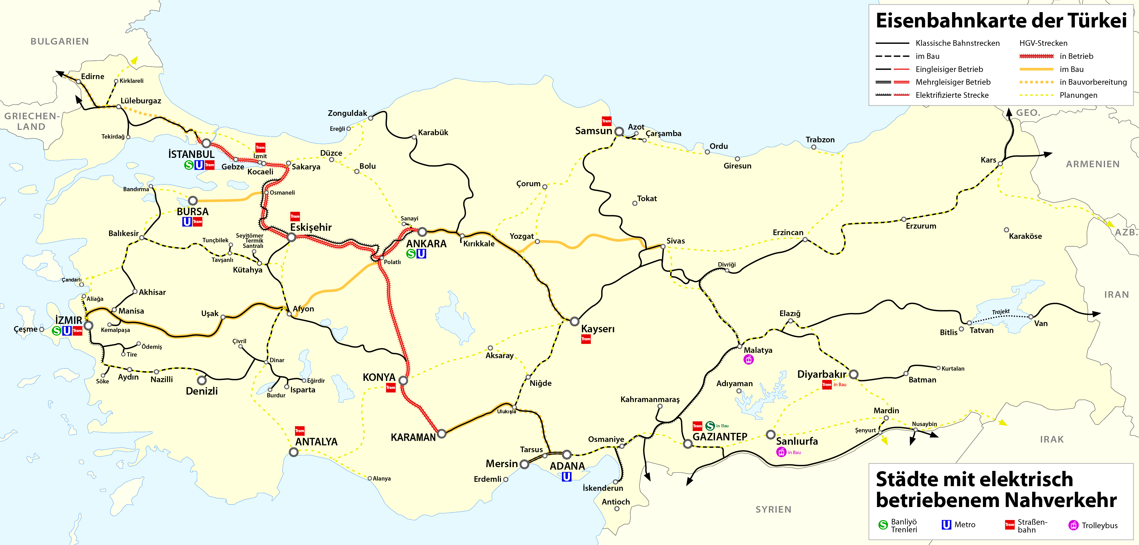
Deutsch: Eisenbahnkarte der Türkei
English: Railway map of Turkey
Français : Carte des chemins de fer de la Turquie |
| Date | see file history |
| Source | Own work |
| Author | Maximilian Dörrbecker (Chumwa) |
| Permission (Reusing this file) |
I, the copyright holder of this work, hereby publish it under the following license: This file is licensed under the Creative Commons Attribution-Share Alike 2.5 Generic license.
Sie dürfen das Bild zu den folgenden Bedingungen nutzen:
|
File history
Click on a date/time to view the file as it appeared at that time.
| Date/Time | Thumbnail | Dimensions | User | Comment | |
|---|---|---|---|---|---|
| current | 16:40, 9 March 2022 | | 3,656 × 1,750 (789 KB) | Rcsprinter123 | . |
| 13:50, 22 January 2022 |  | 3,656 × 1,750 (788 KB) | Rcsprinter123 | Konya-Karaman high speed rail line was opened on 8 January 2022 | |
| 23:11, 10 November 2018 |  | 3,656 × 1,750 (721 KB) | BRKY24 | Karaman- Ulukisla High Speed construction underway. Plan to connect Candarli Port to commuter rail network at Bergama and connecting both to national grid at Soma under project. Kars-Tbilisi-Baku electrified network in function both for passengers and freight. Gaziantep's commuter rail network Gaziray soon to be finalized. | |
| 20:06, 17 June 2017 |  | 3,656 × 1,750 (686 KB) | Chumwa | update | |
| 21:40, 28 June 2016 |  | 3,656 × 1,750 (684 KB) | Chumwa | Tram Izmit in Bau | |
| 16:11, 12 May 2016 |  | 3,656 × 1,750 (461 KB) | Kopiersperre | optipng | |
| 03:39, 12 May 2016 |  | 3,656 × 1,750 (683 KB) | Chumwa | ||
| 20:27, 9 May 2016 |  | 3,656 × 1,750 (680 KB) | Chumwa | == {{int:filedesc}} == {{Information |Description= {{ de| Eisenbahnkarte der Türkei }} {{ en| Railway map of Turkey }} {{ fr| Carte des chemins de fer de la Turquie }} |Source=Self made |Date=see file history |Author= [[:de:User:Chumwa|Maximilian Dör... |
File usage
The following pages on the English Wikipedia use this file (pages on other projects are not listed):
- Ankara Tren Garı
- Ankara–Istanbul high-speed railway
- Ankara–Sivas high-speed railway
- Bilecik YHT railway station
- Bozüyük YHT railway station
- Cilicia
- High-speed rail in Europe
- High-speed rail in Turkey
- List of railway lines in Turkey
- Marşandiz train collision
- Mersin–Adana–Gaziantep railway
- Nurdağı–Başpınar railway
- Polatlı YHT railway station
- Polatlı–Konya high-speed railway
- Polatlı–İzmir high-speed railway
- TCDD HT65000
- TCDD HT80000
- Transport in Turkey
- Turkish State Railways
- Yüksek Hızlı Tren
- User:Central Data Bank/Turkish State Railways
- Wikipedia:Graphics Lab/Map workshop/Archive/Aug 2023
- Wikipedia:Graphics Lab/Map workshop/Archive/Mar 2021
- Template:High-speed rail in Turkey
Global file usage
The following other wikis use this file:
- Usage on ar.wikipedia.org
- Usage on az.wikipedia.org
- Usage on bg.wikipedia.org
- Usage on bs.wikipedia.org
- Usage on cs.wikipedia.org
- Usage on de.wikipedia.org
- Schnellfahrstrecke
- Benutzer:Chumwa
- Türkiye Cumhuriyeti Devlet Demiryolları
- Schienenverkehr in der Türkei
- Liste der Eisenbahnstrecken in der Türkei
- Hochgeschwindigkeitsstrecke Ankara–İstanbul
- Hochgeschwindigkeitsstrecke Ankara–Konya
- Hochgeschwindigkeitsstrecke Ankara–Sivas
- Benutzer:Pechristener/Baustelle2
- Benutzer:Chumwa/SomeOfMyFiles
- Schnellfahrstrecke Halkalı–Kapıkule
- Usage on el.wikivoyage.org
- Usage on es.wikipedia.org
- Usage on es.wikivoyage.org
- Usage on fa.wikipedia.org
- Usage on fr.wikipedia.org
- Usage on fr.wikivoyage.org
- Usage on he.wikipedia.org
- Usage on hu.wikipedia.org
- Törökország közlekedése
- Törökország vasúti közlekedése
- Nagysebességű vasútvonalak Európában
- Nagysebességű vasútvonalak listája
- Törökország nagysebességű vasúti közlekedése
- Török Államvasutak
- Isztambul–Ankara nagysebességű vasútvonal
- Ankara–Konya nagysebességű vasútvonal
- Sablon:Törökország nagysebességű vasúti közlekedése
- TCDD HT80000 sorozat
- Usage on id.wikipedia.org
- Usage on it.wikipedia.org
- Usage on it.wikivoyage.org
- Usage on ja.wikipedia.org
- Usage on ka.wikipedia.org
- Usage on nl.wikipedia.org
View more global usage of this file.