
Size of this preview: 800 × 564 pixels. Other resolutions: 320 × 226 pixels | 640 × 451 pixels | 1,024 × 722 pixels | 1,228 × 866 pixels.
Original file (1,228 × 866 pixels, file size: 25 KB, MIME type: image/png)
| This is a file from the Wikimedia Commons. Information from its description page there is shown below. Commons is a freely licensed media file repository. You can help. |
Summary
| Description |
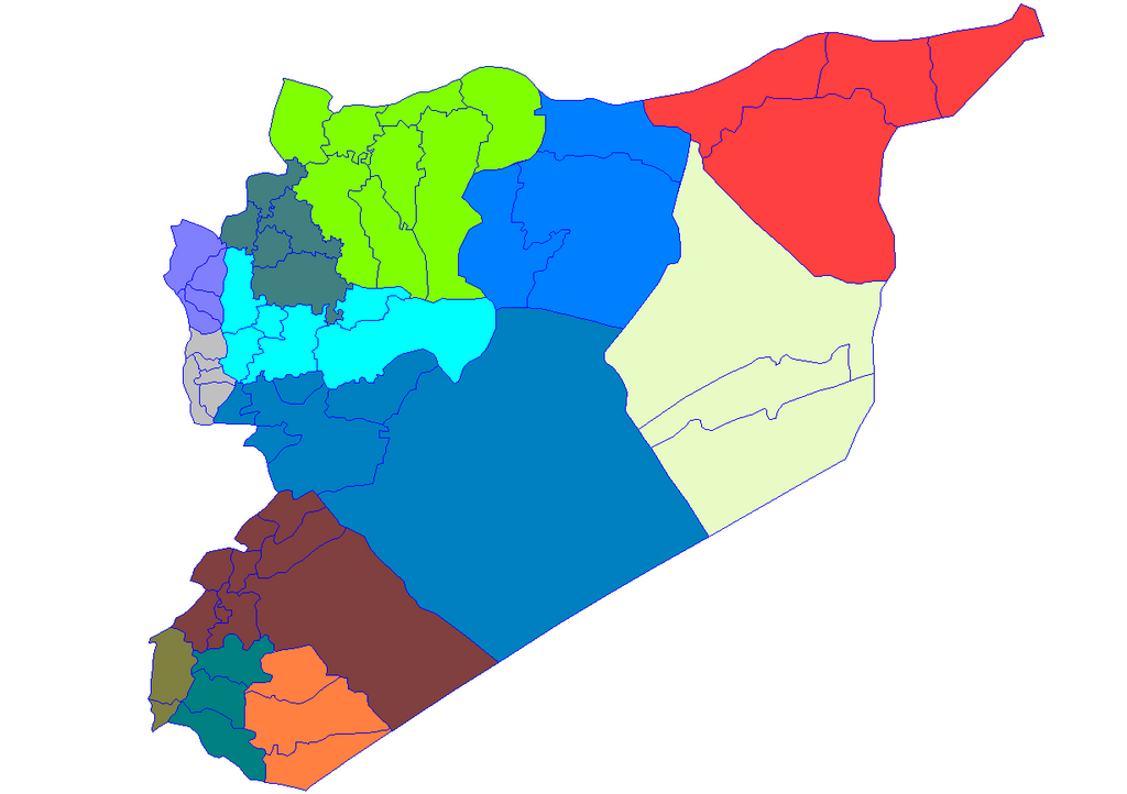
English: Historic map of the districts of Syria. It does not show districts that have been created since 2007, eg, Atarib, Dayr Hafir and Qudsaya. |
||
| Date | |||
| Source | Created by Rarelibra 15:51, 8 May 2007 (UTC) for public domain use, using MapInfo Professional v8.5 and various mapping resources. | ||
| Author | Rarelibra | ||
| Permission (Reusing this file) |
|
File history
Click on a date/time to view the file as it appeared at that time.
| Date/Time | Thumbnail | Dimensions | User | Comment | |
|---|---|---|---|---|---|
| current | 19:28, 8 May 2007 | | 1,228 × 866 (25 KB) | Anas Salloum | modified with permission of original author |
| 15:51, 8 May 2007 |  | 1,281 × 878 (21 KB) | Rarelibra | Map of the districts of Syria. Created by ~~~~ for public domain use, using MapInfo Professional v8.5 and various mapping resources. |
File usage
More than 100 pages use this file. The following list shows the first 100 pages that use this file only. A full list is available.
- Abu Kamal
- Abu al-Duhur
- Afrin, Syria
- Al-Bab
- Al-Dumayr
- Al-Haffah
- Al-Hasakah
- Al-Hawl
- Al-Hirak, Syria
- Al-Jiza, Syria
- Al-Kiswah
- Al-Malikiyah
- Al-Mukharram
- Al-Nabek
- Al-Qadmus
- Al-Qahtaniyah, al-Hasakah
- Al-Quriyah
- Al-Qusayr, Syria
- Al-Qutayfah
- Al-Rastan
- Al-Shaykh Badr
- Al-Suqaylabiyah
- Al-Tall, Syria
- Al-Yaarubiyah
- Al-Zabadani
- Aleppo
- Ariha, Idlib
- Armanaz
- As-Safira
- As-Suwayda
- Atarib
- Azaz
- Babbila
- Baniyas
- Bosra
- Damascus
- Daraa
- Darayya
- Darkush
- Dayr Hafir
- Deir ez-Zor
- Districts of Syria
- Douma, Syria
- Duraykish
- Ghabaghib
- Hama
- Harem, Syria
- Harran al-Awamid
- Hirbnafsah
- Homs
- Idlib
- Izra
- Jableh
- Jarabulus
- Jaramana
- Jindires
- Jisr ash-Shughur
- Kafr Zita
- Khanasir
- Kobani
- Latakia
- List of cities in Syria
- Maaloula
- Maarat al-Numan
- Madaya, Syria
- Manbij
- Markada
- Mashta al-Helu
- Maskanah
- Masyaf
- Mayadin
- Mharda
- Palmyra (modern)
- Qalaat al-Madiq
- Qamishli
- Qardaha
- Qatana
- Qudsaya
- Quneitra
- Qurqania
- Raqqa
- Ras al-Ayn
- Rasm Harmil al-Imam
- Safita
- Saidnaya
- Salamiyah
- Shahba
- Shaqqa
- Sharran
- Shaykh al-Hadid
- Suluk, Syria
- Tadef
- Taldou
- Talkalakh
- Tartus
- Tell Abyad
- Timeline of Damascus
- Timeline of Hama
- Uqayribat
- Wadi al-Uyun
View more links to this file.
Global file usage
The following other wikis use this file:
- Usage on ar.wikipedia.org
- Usage on azb.wikipedia.org
- Usage on az.wikipedia.org
- Usage on bn.wikipedia.org
- Usage on ckb.wikipedia.org
- ویکیپرۆژە:کۆمەڵە وتارەکان/شارەکانی سووریا/ڕەگ
- حەلەب
- لازقیە
- حەما
- دێرەزوور
- ڕەققە
- ئیدلیب
- ئەلباب
- دوما
- جەرمانا
- سەلەمیە
- دەرعا
- حەجەر ئەسوەد
- مەعەڕەت نوعمان
- تەرتووس
- دارەیا
- ئەلتەورە
- جەبلە
- سووەیدا
- نەوا، سووریا
- ئەلتەل
- ئەلڕەستەن
- ئەریحا
- ئەلنەبک
- مەیادین
- یەبرود
- قوسەیر
- حەرەستا
- جسر شوغور
- بانیاس
- جەیرود
- قەریەتەین
- مەعڕەت مسرین
- مەسیاف
View more global usage of this file.