File:UEFA European Championship best results.svg

Original file(SVG file, nominally 615 × 520 pixels, file size: 452 KB)

Summary

Description
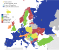
English: Map showing the best results of each country in the UEFA European Championship
Монгол: Европ тивийн хөлбөмбөгийн аварга шалгаруулах тэмцээн дэх улс орон бүрийн хамгийн сайн үр дүнг харуулсан газрын зураг
Malagasy : Sarintany mampiseho ny vokatra tsara indrindra avy amin'ny firenena tsirairay ao amin'ny UEFA Eoropeana
Deutsch: Karte mit den besten Ergebnissen jedes Landes bei der Fussball-Europameisterschaft
Srpskohrvatski / српскохрватски: Karta prikazuje najbolje rezultate svake zemlje na UEFA Euro
Tiếng Việt: Bản đồ hiển thị kết quả tốt nhất của từng quốc gia trong Giải vô địch bóng đá châu Âu
Tagalog: Mapa na nagpapakita ng pinakamahusay na mga resulta ng bawat bansa sa UEFA European Championship
Oʻzbekcha / ўзбекча: UEFA Evropa chempionatida har bir mamlakatning eng yaxshi natijalarini ko'rsatadigan xaritaz
Date
Source This file was derived from: Blank map of Europe (with disputed regions).svg
Author Own work
Other versions File:European_Football_Championship_best_results.png

Licensing

I, the copyright holder of this work, hereby publish it under the following licenses:
GNU head Permission is granted to copy, distribute and/or modify this document under the terms of the GNU Free Documentation License, Version 1.2 or any later version published by the Free Software Foundation; with no Invariant Sections, no Front-Cover Texts, and no Back-Cover Texts. A copy of the license is included in the section entitled GNU Free Documentation License.
w:en:Creative Commons
attribution share alike
This file is licensed under the Creative Commons Attribution-Share Alike 4.0 International, 3.0 Unported, 2.5 Generic, 2.0 Generic and 1.0 Generic license.
You are free:
  • to share – to copy, distribute and transmit the work
  • to remix – to adapt the work
Under the following conditions:
  • attribution – You must give appropriate credit, provide a link to the license, and indicate if changes were made. You may do so in any reasonable manner, but not in any way that suggests the licensor endorses you or your use.
  • share alike – If you remix, transform, or build upon the material, you must distribute your contributions under the same or compatible license as the original.
You may select the license of your choice.

Original upload log

The original description page was here. All following user names refer to en.wikipedia.
  • 2015-03-10 22:16:59 GarethTJennings 587×456 (695503 bytes) Map showing the best results of each country that has ever qualified for a EC
  • 2015-03-10 23:41:30 GarethTJennings 587×456 (698779 bytes)

Captions

Add a one-line explanation of what this file represents

Items portrayed in this file

depicts

10 March 2015

File history

Click on a date/time to view the file as it appeared at that time.

(newest | oldest) View (newer 10 | ) (10 | 20 | 50 | 100 | 250 | 500)
Date/TimeThumbnailDimensionsUserComment
current22:27, 11 July 2021Thumbnail for version as of 22:27, 11 July 2021615 × 520 (452 KB)SangjinhwaUpdate
22:59, 3 July 2021Thumbnail for version as of 22:59, 3 July 2021615 × 520 (446 KB)そらみみUpdate after QF
21:11, 28 June 2021Thumbnail for version as of 21:11, 28 June 2021615 × 520 (446 KB)そらみみUpdating after 2020 (2021) QF, adding host countries
18:25, 11 July 2016Thumbnail for version as of 18:25, 11 July 2016615 × 520 (455 KB)GarethTJenningsCropping
21:58, 10 July 2016Thumbnail for version as of 21:58, 10 July 2016811 × 520 (486 KB)ThecentreCZEuro 2016 Winner - Portugal
05:18, 6 July 2016Thumbnail for version as of 05:18, 6 July 2016615 × 520 (455 KB)GarethTJenningsUpdating to after 2016 QFs
18:19, 14 June 2016Thumbnail for version as of 18:19, 14 June 2016615 × 520 (455 KB)GarethTJenningsAdding Kosovo and removing dot from Albania
18:18, 12 June 2016Thumbnail for version as of 18:18, 12 June 2016615 × 520 (454 KB)GarethTJenningsHost country, not host city
12:14, 31 May 2016Thumbnail for version as of 12:14, 31 May 2016615 × 520 (452 KB)MatissekGeographic corrections - Soviet Union, Yugoslavia and Czechoslovakia consisted of different territories at the time. Added a host city legend as well.
22:28, 10 March 2015Thumbnail for version as of 22:28, 10 March 2015587 × 456 (682 KB)GarethTJenningsAdding key
(newest | oldest) View (newer 10 | ) (10 | 20 | 50 | 100 | 250 | 500)
The following pages on the English Wikipedia use this file (pages on other projects are not listed):

Global file usage

Metadata