Forst (Lausitz) (German) or Baršć (Łužyca) (Lower Sorbian, pronounced [ˈbarɕtɕ ˈwuʒɨtsa]) is a town in Lower Lusatia, Brandenburg, in eastern Germany. It lies east of Cottbus, on the Lusatian Neisse river which is also the German-Polish border. It is the capital of the Spree-Neiße district. It is known for its rose garden and textile museum. The town's population is 18,651. In Forst, there is a railway bridge across the Neiße belonging to the line Cottbus–Żary which is serviced by regional trains and a EuroCity train between Hamburg and Kraków (2011). There is also a road bridge across the river north of Forst.
Forst (Lausitz)
Baršć (Łužyca) | |
|---|---|
_-_PatLografie_-_Patrick_Lucia.jpg)   _-_geo.hlipp.de_-_38938.jpg)  _St._Nikolaikirche_Panorama_Kirchturm_02.jpg) From top: water tower St Nicholas' Church church in Naundorf (Glinsk) Ostdeutscher Rosengarten Forst (Lausitz) station view from St Nicholas' Church | |
.svg) Flag .svg) Coat of arms | |
Location of Forst (Lausitz) within Spree-Neiße district 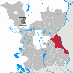 | |
 Forst (Lausitz)  Forst (Lausitz) | |
| Coordinates: 51°44′N 14°38′E / 51.733°N 14.633°E | |
| Country | Germany |
| State | Brandenburg |
| District | Spree-Neiße |
| Government | |
| • Mayor (2018–26) | Simone Taubenek[1] |
| Area | |
| • Total | 109.91 km2 (42.44 sq mi) |
| Elevation | 72 m (236 ft) |
| Population (2022-12-31)[2] | |
| • Total | 17,855 |
| • Density | 160/km2 (420/sq mi) |
| Time zone | UTC+01:00 (CET) |
| • Summer (DST) | UTC+02:00 (CEST) |
| Postal codes | 03141–03149 |
| Dialling codes | 03562 |
| Vehicle registration | SPN |
| Website | www.forst-lausitz.de |
Incorporated villages edit
- Forst (Lausitz) – Baršć (Łužyca)
- Domsdorf – Domašojce
- Eigene Scholle – Swójske Grunty
- Eulo – Wiłow
- Försterei Keune – Gólnikaŕnja Chójna
- Keune – Chójna
- Mexiko
- Noßdorf – Nosydłojce
- Bohrau – Bórow
- Briesnig – Rjasnik
- Groß Bademeusel – Wjelike Bóžemysle
- Groß Jamno – Jamne
- Horno – Rogow
- Klein Bademeusel – Małe Bóžemysle
- Försterei Bademeusel – Bóžemyslańska Gólnikaŕnja
- Klein Jamno – Małe Jamne
- Mulknitz – Małksa
- Naundorf – Glinsk
- Neu Sacro – Nowy Zakrjow
- Sacro – Zakrjow
History edit
A short distance to the south of the old Sorbian village of Altforst, the town probably originated around 1150 at a river crossing point on the important west–east trade route. Known as the "Salt Road", it was used to transport salt from Halle to Lusatia and further east to Poland.[3] By 1265 it was developing into a permanent trading settlement round the Church of St Nicholas. The commercial importance of Forst increased with the development of a north–south route connecting to Guben, downstream along the Neisse River. In the fourteenth century the council was able to take on responsibility for the lower courts locally. In 1352 of Ileburg took over the overlordship of Forst from Frederick III of Meissen. At various times the town was under the suzerainty of Bohemian, Hungarian, Saxon and Polish monarchs. In 1628, clothiers from Leszno, Międzyrzecz and Wschowa in Poland settled in the town.[4] In 1746, it was purchased by Heinrich von Brühl, minister of Augustus III of Poland.[4] In 1749, a new postal route was established from Warsaw and Poznań to Dresden, which led through the town.[5]
Forst was awarded to the Kingdom of Prussia in the 1815 Congress of Vienna.[4] The town was administered as a part of the Province of Brandenburg from 1815 to 1947. During World War II, in 1942–1943, the Germans operated a forced labour camp for Jewish men in the town.[6] After the war it became part of the State of Brandenburg, which became one of the constituent parts of the German Democratic Republic in 1949. From 1952 to 1990, it was part of the East German Bezirk Cottbus. Since German reunification in 1990, it is again part of Brandenburg.
Forst has experienced severe problems as a result of the 1990 German reunification, most notably from extreme unemployment. In the past, the town was known for textile manufacturing, but all of the textile plants and factories have closed down.
Demography edit
-
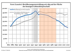 Development of population since 1875 within the current Boundaries (Blue Line: Population; Dotted Line: Comparison to Population development in Brandenburg state; Grey Background: Time of Nazi Germany; Red Background: Time of communist East Germany)
 -
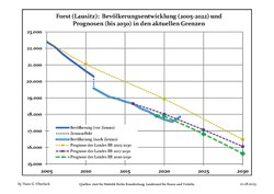 Recent Population Development and Projections (Population Development before Census 2011 (blue line); Recent Population Development according to the Census in Germany in 2011 (blue bordered line); Official projections for 2005-2030 (yellow line); for 2017-2030 (scarlet line); for 2020-2030 (green line)


|
|
|
Notable people edit
- Hugo Baum (1867–1950), botanist
- Georg Thomas (1890–1946), general of infantry
- Bruno Kastner (1890–1932), film and stage actor
- Max Seydewitz (1892–1987), politician (SPD, SED)
- Brigitte Frank, née Herbst (1895–1959), wife of Hans Frank
- Erich Neumann (1892–1948), politician (NSDAP)
- Werner Heyde (1902–1964), psychiatrist, involved in the T 4 program
- Georg Bose (1921–2011), German officer during World War II
- Günter Nooke (born 1959), politician (CDU)
- Dietmar Woidke (born 1961), politician (SPD)
- René Rydlewicz (born 1973), footballer
- Ronny Scholz (born 1978), cyclist
See also edit
References edit
- ^ Landkreis Spree-Neiße Wahl der Bürgermeisterin / des Bürgermeisters, accessed 2 July 2021.
- ^ "Bevölkerungsentwicklung und Bevölkerungsstandim Land Brandenburg Dezember 2022" (PDF). Amt für Statistik Berlin-Brandenburg (in German). June 2023.
- ^ Pieradzka, Krystyna (1949). "Związki handlowe Łużyc ze Śląskiem w dawnych wiekach". Sobótka (in Polish). IV (4). Wrocław: 90.
- ^ a b c "Chronik der Stadt Forst (Lausitz)". Stadt Forst (Lausitz) (in German). Retrieved 17 November 2023.
- ^ Rafał Zgorzelski. "Polska Poczta w dobie saskiej – panowanie Augusta III Wettina" (in Polish). Archived from the original on 15 March 2016. Retrieved 17 November 2023.
- ^ "Zwangsarbeitslager für Juden Forst (Lausitz)". Bundesarchiv.de (in German). Retrieved 17 November 2023.
- ^ Detailed data sources are to be found in the Wikimedia Commons.Population Projection Brandenburg at Wikimedia Commons
External links edit
 Media related to Forst (Lausitz) at Wikimedia Commons
- Official website of Forst (Lausitz) (in German)
- Forst's Rose Garden (in German)
- . Encyclopædia Britannica (11th ed.). 1911.
- . New International Encyclopedia. 1905.