Guiseley (/ˈɡaɪzlɪ/ GHYZE-lee)[1] is a town in metropolitan borough of the City of Leeds, West Yorkshire, England. Historically part of the West Riding of Yorkshire, it is situated south of Otley and Menston and is now a north-western suburb of Leeds.
| Guiseley | |
|---|---|
 A view of Guiseley from the tower of St Oswald's church | |
 Guiseley  Guiseley Location within West Yorkshire | |
| Population | 22,347 (ward Guiseley and Rawdon. 2011) |
| OS grid reference | SE193422 |
| • London | 175 mi (282 km) S |
| Metropolitan borough | |
| Metropolitan county | |
| Region | |
| Country | England |
| Sovereign state | United Kingdom |
| Post town | LEEDS |
| Postcode district | LS20 |
| Dialling code | 01943 |
| Police | West Yorkshire |
| Fire | West Yorkshire |
| Ambulance | Yorkshire |
| UK Parliament | |
It sits in the Guiseley and Rawdon ward of Leeds City Council and the Pudsey parliamentary constituency. At the 2001 census, Guiseley with Rawdon had a population of over 21,000,[2] increasing to 22,347 at the 2011 Census.[3]
The A65, which passes through the town, is the main shopping street. Guiseley railway station has regular train services into Leeds, Bradford and Ilkley stations on the Wharfedale Line.
Etymology edit
The name of Guiseley is first attested in an eleventh-century copy of a charter from around 972, as Gislicleh; it next appears in the Domesday Book of 1086 as Gisele and similar variants. The early spelling suggests that the first element of the name is an Old English personal name Gīslic. No such name is otherwise attested, but it is a plausible nickname form of names beginning in Gīsl-, such as Gīslbeorht. The second element comes from the Old English word lēah ('open land in woodland'). Thus the name seems once to have meant 'Gīslic's clearing'.[4][5]
The etymologies of local field- and steet-names were studied in detail by Henry R. Daniels.[6]
History edit


There have been Stone Age and Bronze Age finds in Guiseley and a Roman road, Road 72b, ran nearby on Guiseley Moor.[7] A Saxon settlement existed around a spring which is now called Guiseley Wells and provided drinking water.[7]
It was a largely farming community until the 18th century, when cottage-based woollen industry arose. In Victorian times it became industrialized, acquiring a railway connection in 1865 and a town hall (now Guiseley Theatre) in 1867.[7]
Guiseley was an ancient parish in the West Riding of Yorkshire from the 12th century. The parish also included the townships of Carlton, Horsforth, Rawdon and Yeadon, all of which became separate civil parishes in 1866.[7] In 1937 the civil parish of Guiseley was abolished and merged into the new Aireborough Urban District.[8] In 1974 Aireborough was itself abolished and absorbed into the City of Leeds Metropolitan District in the new county of West Yorkshire.
St Oswald's Church edit

Guiseley's church, dedicated to St Oswald, was the centre of a large parish that included many surrounding villages. It was used by generations of the Longfellow family. Henry Wadsworth Longfellow's 5th great-grandfather left here for the New World in the 17th century. The rector of St Oswald's for several decades was Rev. Robert More (died in 1642), the father-in-law of the English explorer, Captain Christopher Levett.[9] Patrick Brontë and Maria Branwell were married at St Oswald's[7] and became the parents of six children, including Anne, Branwell, Charlotte and Emily Brontë.
Business edit

Crompton Parkinson was a major employer until its factory closed in 2004. The town was the home of Silver Cross, a pram manufacturer, whose factory was operational from 1936 to 2002.[10]
The town is known for Harry Ramsden, whose fish and chip shop traded from a small shed next to the tram terminus at White Cross. In 1930 he opened "the world's biggest fish and chip shop". The original restaurant was closed in December 2011. The Wetherby Whaler group purchased the site and planned a £500,000 refurbishment to open during the summer of 2012.[11] The new Wetherby Whaler restaurant opened on 22 May 2012.
Amenities edit
Guiseley has two retail parks: Guiseley Retail Park in the centre of town, and Westside Retail Park between Guiseley and Yeadon. The town has a Morrisons supermarket, charity shops and beauty stores on the High Street, as well as many pubs, bars, takeaways and restaurants located around the town and a leisure centre with a swimming pool and gym on The Green.
Many of the retail outlets in the town have been established on the converted sites of old factories or mills. Recently, an increasing number of stores of well known leading brands such as Argos, TK Maxx, Marks & Spencer (food), Asda Living, Currys, Costa Coffee, Next and Sports Direct have been opened in the area. McDonald's, KFC and Subway all have stores in the town.
Places of worship edit
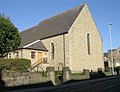
In addition to St Oswald's there is also Guiseley Methodist Church and Guiseley Baptist Church which was built in 1883 on Oxford Road in the old town, and the Kingdom Hall of Jehovah's Witnesses on Otley Road.
-
 Guiseley Methodist Church
 -
 Guiseley Baptist Church


Sports and recreation edit

Guiseley's professional football team, Guiseley A.F.C., play at Nethermoor Park. They played in the Conference North during the 2014–15 season, gaining promotion to the Conference Premier through the playoffs. Guiseley Cricket Club shares the club house and plays in the Airedale-Wharfedale Senior Cricket League.[12] Aireborough RUFC play at Nunroyd Park.[13] Local philanthropist Jonathan Peate gave Nethermoor Park (Guiseley) and Nunroyd Park (between Yeadon and Guiseley) to local people in the early 20th century. Two other parks were regenerated in 2011/12, Springfield Road and Parkinson's Park.[14] Parkinson's Park was given to Guiseley in the 1930s by Frank and Albert Parkinson. By 2002 it had become a wasteland with frequent occurrences of antisocial behaviour. It is now owned by Bellway Homes.
Guiseley is also home to England Athletics registered running club Airecentre Pacers.[15]
Media edit
Local news and television programmes are provided by BBC Yorkshire and ITV Yorkshire. Television signals are received from the Emley Moor TV transmitter.[16] Local radio stations are BBC Radio Leeds, Heart Yorkshire, Capital Yorkshire, Pulse 1, and Greatest Hits Radio West Yorkshire.[17] The town is served by the local newspapers, Gazette & Observer and Telegraph & Argus.
Schools edit
Guiseley School on Fieldhead Road[18] was built as a secondary modern in the 1960s and is sometimes known as Fieldhead School. Aireborough Grammar School opened in 1910 and closed in 1991.[19]
Primary schools include Tranmere Park School[20] and St. Oswald's C of E School.[21]
Notable people edit
Walter Fawkes, Writer and Member of Parliament
Frank Parkinson, notable Electrical Engineer
Andy Haldane, Chief Economist at the Bank of England
Sports
Jack Brumfitt, English first-class Cricketer
Hugh Claughton, English first-class Cricketer
John Alan Claughton, English first-class Cricketer
Peter Pullan, English first-class Cricketer
Jack van Geloven, English first-class Cricketer
Josh Windass, English Footballer
Entertainment
Burt Rhodes, Music Director
Harry Corbett, known for his children's television glove puppet character Sooty stage act, lived with his parents in the town.[22]
Matthew Corbett, Entertainer
Tasmin Archer, whose co-written song "Sleeping Satellite" reached number one in the UK charts, and Maurice Lee of The Grumbleweeds lived in the town.[23]
Craig McKay, Actor
Glenda McKay, Actor
Belinda O’Hooley, Singer-Songwriter and Pianist
Peter Grant, Jazz Singer
Geography edit
Guiseley is situated in a hanging valley between Airedale and Wharfedale. The A65 road passes through, there is a railway station and Leeds Bradford Airport is nearby.
See also edit
References edit
- ^ BBC Pronouncing Dictionary of British Names
- ^ "2001 Census Pdf" (PDF). Retrieved 20 September 2010.
- ^ "City of Leeds Ward population". Neighbourhood Statistics. Office for National Services. Retrieved 27 February 2016.
- ^ Parsons, Edward (1834); The Civil, Ecclesiastical History of Leeds, Halifax, Huddersfield and the Manufacturing District of Yorkshire, p. 217.
- ^ Parkin, Harry Your City's Place-Names: Leeds, English Place-Name Society City-Names Series, 3 (Nottingham: English Place-Names Society, 2017), p. 50.
- ^ Daniels, Henry R. (1997–98). "Conservation and Innovation in the Toponymy of a West Riding Township". Journal of the English Place-Name Society. 30: 107–53.
- ^ a b c d e "A brief history of Guiseley". www.aireboroughcivicsociety.org.uk. Aireborough Civic Society. Retrieved 22 July 2017.
- ^ Vision of Britain website
- ^ Will of Rev. Robert More, Christopher Levett of York: The Pioneer Colonist in Casco Bay, James Phinney Baxter, Printed for the Gorges Society, Vol. 5, Portland, Maine, 1893
- ^ "History". Silver Cross. 2017.
- ^ "First Harry Ramsden's chip shop bought by Whaler Group". BBC News. 6 February 2012.
- ^ "Home". Retrieved 20 September 2010.
- ^ "Aireborough RUFC". Retrieved 20 September 2010.
- ^ "Parkinson's Park website". Retrieved 23 March 2012.
- ^ "Airecentre Pacers Running Club". Retrieved 1 November 2016.
- ^ "Emley Moor (Kirklees, England) Full Freeview transmitter". UK Free TV. 1 May 2004. Retrieved 20 January 2024.
- ^ "Yorkshire Radio Stations". Retrieved 20 January 2024.
- ^ "Home - Guiseley School Website". Archived from the original on 9 September 2010. Retrieved 20 September 2010.
- ^ "Aireborough Grammar School". Retrieved 20 September 2010.
- ^ "Tranmere Park". Retrieved 20 September 2010.
- ^ "St Oswald's C of E Junior School, Leeds :: Home Page". Retrieved 20 September 2010.
- ^ McIntyre, Annette; "Guiseley chip shop wraps up place in TV show", Wharfedale and Aireborough Observer, 30 April 2008. Retrieved 11 June 2008
- ^ "Otley author - and son of a Grumbleweed - receiving rave reviews for debut novel". Wharfedale and Aireborough Observer. 17 June 2016. Retrieved 16 September 2018.
External links edit
- Guiseley On The Net
- Guisely Baptist Church website
- Guiseley School website
- "The Ancient Parish of Guiseley". GENUKI. Retrieved 29 October 2007.