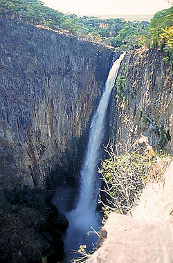
The Kalambo River forms part of the border between Zambia and Tanzania. It is a comparatively small stream which rises on the Ufipa Plateau in Rukwa Region,Tanzania north-east of Mbala at an elevation of about 1800 m and descends into the Albertine Rift, entering the southeastern end of Lake Tanganyika at an elevation of about 770 m, in a straight-line distance of only about 50 km.[citation needed] This accounts for its main claim to fame, its waterfall, Kalambo Falls, which is Africa's second highest falls (after South Africa's Tugela Falls). Below the falls, the river runs in a deep gorge.[citation needed]
| Kalambo River | |
|---|---|
 Kalambo Falls | |
| Location | |
| Country | Rukwa Region, Tanzania |
| Country | Northern Province, Zambia |
| Physical characteristics | |
| Source | Ufipa Plateau |
| • location | Zambia |
| • elevation | 1,800 m (5,900 ft) |
| Mouth | Lake Tanganyika |
• location | Tanzania |
• elevation | 770 m (2,530 ft) |
| Length | 50 km (31 mi) |
The site of the river includes important archaeological sites.
References edit
- UNESCO, World Heritage Centre, Kalambo falls archaeological site (prehistoric settlement site), 11/06/1997.
- "Forestry." Encyclopædia Britannica. 2006. Encyclopædia Britannica Online. 17 June 2006 <http://search.eb.com/eb/article-26182>.
External links edit
- "Photo Gallery: Children enjoy a swim in Kalambo River at Kapozwa Village near Lake Tanganyika in Kalambo District, Rukwa Region". 2012. Archived from the original on 2012-09-04. Retrieved 2012-09-04.