Merton Street is a cobbled street in central Oxford, England.[1][2] It joins the High Street at its northeastern end, between the Ruskin School of Drawing and Fine Art (together with the Examination Schools) and the Eastgate Hotel at the historic east gate of the city. It then runs east–west, parallel and to the south of the High Street for most of its length.
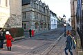
 Looking west along Merton Street in April 2021 towards the Canterbury Gate of Christ Church. | |
 Location within Central Oxford | |
| Former name(s) | Coach & Horses LaneKing StreetSt John Baptist’s Street |
|---|---|
| Namesake | Walter de Merton |
| Location | Oxford, United Kingdom |
| Postal code | OX1 |
| Coordinates | 51°45′05″N 1°15′06″W / 51.7514°N 1.2518°W |
| West end | Christ Church |
| East end | Examination School / Ruskin School of Art |
| Other | |
| Known for | |
Location edit
Merton College, one of Oxford's older colleges, is situated to the south of the street. To the west of Merton, Corpus Christi College, one of Oxford's smallest colleges, also fronts onto the street. At the very western end, actually in Oriel Square, is an entrance to Christ Church, Oxford's largest college. At the eastern end can be found the notorious 'Pink House', as well as an entrance to University College.
Logic Lane (through University College, which backs onto the street) and Magpie Lane, both narrow lanes, lead off the street to the north. Also located here is the Merton Street tennis court, a rare example of an extant real tennis court. To the south is Merton Grove (opposite Magpie Lane), providing pedestrian access between Merton College and Corpus Christi College to Christ Church Meadow to the south.
The street is designated the A420 due to the blockage of the High Street to normal traffic. To the west it continues through Oriel Square, where Oriel College is located.[citation needed]
Despite being cobbled, the street has been repaired by Oxford City Council using asphalt.[3]
History edit
The part of modern-day Merton Street adjoining the High Street used to be known as Coach & Horses Lane, named after a public house on the west side of the lane.[2] From the early 18th to the late 19th century, it became known as King Street.
The rest of the street (the part running east–west) was originally known as St John Baptist's Street, named after the church which is now Merton College's chapel. In 1751, the whole street had become King Street, but by 1772 just the east–west part was called Merton Street. The entire street became known as Merton Street only in the 20th century.
Notable residents edit
Siegfried Sassoon briefly took rooms in no 14 during 1919, on the recommendation of Lady Ottoline Morrell.[4] The historian Michael Brock (1920–2014) and his wife (and co-editor) Eleanor lived in the street in the early 1950s.[5] The academic and author J. R. R. Tolkien had rooms in Merton Street towards the end of his life in the early 1970s.
Gallery edit
-
 Looking down Merton Street, at the corner with Oriel Square, looking east towards Merton College.
 -
 Looking east along Merton Street from the south side at the junction with Magpie Lane.


References edit
- ^ Hibbert, Christopher, ed. (1988). "Merton Street". The Encyclopaedia of Oxford. Macmillan. p. 256. ISBN 0-333-39917-X.
- ^ a b Merton Street, High Street, Oxford.
- ^ Heard, Dan (27 March 2010). "Repairs 'messing up' historic city street". Oxford Mail. Retrieved 14 September 2012.
- ^ Jean Moorcroft Wilson, Siegfried Sassoon: the Journey from the Trenches (Duckworth, 2003) ISBN 0715633244 p33
- ^ "Eminent dean and scholar whose historical work is published soon". Oxford Mail. 22 May 2014. Retrieved 26 May 2014.
External links edit
 Media related to Merton Street, Oxford at Wikimedia Commons