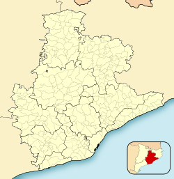
Montcada i Reixac (Catalan pronunciation: [muŋˈkaðəj rəˈʃak]), often referred to as simply Montcada, is a municipality in the comarca of the Vallès Occidental in Catalonia, Spain. It is situated at the confluence of the Ripoll river and the Besós river, and very close to the northernmost neighbourhoods of the city of Barcelona and is therefore a part of the metropolitan area of Barcelona. It had 33,656 inhabitants according to the 2010 census.
Montcada i Reixac | |
|---|---|
 Aerial view of Montcada i Reixac | |
| Coordinates: 41°29′14″N 2°11′16″E / 41.48722°N 2.18778°E | |
| Country | |
| Community | |
| Province | Barcelona |
| Comarca | Vallès Occidental |
| Government | |
| • Mayor | Laura Campos Ferrer (2015)[1] |
| Area | |
| • Total | 23.5 km2 (9.1 sq mi) |
| Elevation | 36 m (118 ft) |
| Population (2018)[3] | |
| • Total | 35,599 |
| • Density | 1,500/km2 (3,900/sq mi) |
| Demonym(s) | Montcadenc, montcadenca |
| Website | montcada |
Neighbourhoods edit
The following areas make up the urban tissue of Montcada: Can Cuiàs, Can Pomada, Can Sant Joan (Bifurcació), Carrerada (Montcada Nova), Font Pudenta, La Ribera (Valentine), Mas Duran, Mas Rampinyo, Montcada Centre, Pla d'en Coll, Terra Nostra (Santa Maria de Montcada) i Vallençana-Reixac. The municipality includes a small exclave to the north between Palau-solità i Plegamans and Mollet del Vallès.
Transport edit
The town is served by the A-7 autopista, the N-152 road, six Renfe Rodalies Barcelona and regional railway stations used by several lines, and the terminus Barcelona Metro line 11, located at Can Cuiàs.
The GR 92 long distance footpath, which roughly follows the length of the Mediterranean coast of Spain, has a staging point at Montcada i Reixac. Stage 17 links northwards to Coll de la Font de Cera, a distance of 16.9 kilometres (10.5 mi), whilst stage 18 links southwards to Baixador de Vallvidrera station, a distance of 16.7 kilometres (10.4 mi).[4]
Twin towns edit
- Águilas, Spain
References edit
- ^ "Ajuntament de Montcada i Reixac". Generalitat of Catalonia. Retrieved 2015-11-13.
- ^ "El municipi en xifres: Montcada i Reixac". Statistical Institute of Catalonia. Retrieved 2015-11-23.
- ^ Municipal Register of Spain 2018. National Statistics Institute.
- ^ "GR 92: Sender de la Mediterrània" [GR 92: Mediterranean Path]. www.catalunya.com (in Catalan). Archived from the original on 7 November 2022. Retrieved 7 November 2022.
- Panareda Clopés, Josep Maria; Rios Calvet, Jaume; Rabella Vives, Josep Maria (1989). Guia de Catalunya, Barcelona: Caixa de Catalunya. ISBN 84-87135-01-3 (Spanish). ISBN 84-87135-02-1 (Catalan).
External links edit
- Montcada i Reixac city council
- Government data pages (in Catalan)


