The National Mall is a landscaped park near the downtown area of Washington, D.C., the capital city of the United States. It contains and borders a number of museums of the Smithsonian Institution, art galleries, cultural institutions, and various memorials, sculptures, and statues. It is administered by the National Park Service (NPS) of the United States Department of the Interior as part of the National Mall and Memorial Parks unit of the National Park System.[4] The park receives approximately 24 million visitors each year.[5]
National Mall | |
.jpg) The National Mall with the Lincoln Memorial and its reflecting pool (foreground), the Washington Monument behind it, and the United States Capitol (background) in 2010 | |
| Location | Between Independence and Constitution Avenues from the Capitol to the Lincoln Memorial |
|---|---|
| Coordinates | 38°53′24″N 77°1′25″W / 38.89000°N 77.02361°W |
| Architect | Pierre (Peter) Charles L'Enfant, McMillan Commission |
| Website | National Mall and Memorial Parks |
| NRHP reference No. | 66000031[1] (original) 16000805[2][3] (increase) |
| Significant dates | |
| Added to NRHP | October 15, 1966 |
| Boundary increase | December 8, 2016 |
The core area of the National Mall extends between the United States Capitol grounds to the east and the Washington Monument to the west and is lined to the north and south by several museums and a federal office building.[6] The term National Mall may also include areas that are also officially part of neighboring West Potomac Park to the south and west and Constitution Gardens to the north, extending to the Lincoln Memorial on the west and Jefferson Memorial to the south.[7]
Landmarks, museums, and other features edit

Within the National Mall proper edit
_satellite_image.jpg)
The National Mall proper contains the following landmarks, museums and other features (including opening year):[7][6]
- 2. National Museum of American History (1964)[8]
- 3. National Museum of Natural History (1910)
- 4. National Gallery of Art Sculpture Garden (1999)
- 5. West Building of the National Gallery of Art (1941)
- 6. East Building of the National Gallery of Art (1978)
- 10. National Museum of the American Indian (2004) (shown under construction)
- 11. National Air and Space Museum (1976)
- 12. Hirshhorn Museum and Sculpture Garden (1974)
- 13. Arts and Industries Building (1881)
- 14. Smithsonian Institution Building ("The Castle") (1849)
- 15. Freer Gallery of Art (1923)
- 16. Arthur M. Sackler Gallery (1987)
- 17. National Museum of African Art (1987)

Not marked on the above image:
- Above the Smithsonian Institution Building
- Joseph Henry statue (1883)[9]
- Below the Smithsonian Institution Building
- Above the Arts and Industries Building
- Smithsonian Carousel (1967)[11]
- To the left of the National Museum of American History
- Site of the present National Museum of African American History and Culture (2016)[12]

- To the left of the Freer Gallery of Art

With the exception of the National Gallery of Art, all of the museums on the National Mall proper are part of the Smithsonian Institution. The Smithsonian Gardens maintains a number of gardens and landscapes near its museums.[14] These include:
- Common Ground: Our American Garden (2017)[15]
- Enid A. Haupt Garden (1987)[16]
- Freer Gallery of Art Courtyard Garden (1923)[17]
- Hirshhorn Museum and Sculpture Garden (1974)[18]
- Kathrine Dulin Folger Rose Garden (1998)[19]
- Mary Livingston Ripley Garden (1978)[20]
- National Air and Space Museum landscape (1976)[21]
- Native landscape at the National Museum of the American Indian (2004)[22]
- Pollinator Garden (1995)[23]
- Urban Bird Habitat (2020)[24]
- Victory Garden (2020)[25]
East of the National Mall proper edit

Features east of the National Mall proper include:
- United States Capitol and its grounds (no. 7 on image)
- Union Square, containing:
- Capitol Reflecting Pool (1971) (no. 8 on image)
- Ulysses S. Grant Memorial (1922) (east of no. 8 on image)
- Peace Monument (1878) (in traffic circle northeast of no. 8 in image)
- United States Botanic Garden (1933) (no. 9 on image)
- James A. Garfield Monument (1887) (in traffic circle northeast of no. 9 in image)
West of the National Mall proper and in West Potomac Park edit


Not included in the above map:
- Lockkeeper's House, C & O Canal Extension (1837)
- Constitution Gardens (1976)
- Memorial to the 56 Signers of the Declaration of Independence (1984)
- District of Columbia War Memorial
- Sylvan Theater
- George Mason Memorial
- John Paul Jones Memorial
- John Ericsson Memorial
- The Arts of War and The Arts of Peace sculptures
- Jefferson Pier
- Tidal Basin paddle-boat dock.
Boundaries and dimensions edit
Dimensions edit
- Between the Capitol steps and the Lincoln Memorial, the Mall spans 1.9 miles (3.0 km).
- Between the Capitol steps and the Washington Monument, the Mall spans 1.2 miles (1.8 km).
- Between the Ulysses S. Grant Memorial and the Lincoln Memorial, the Mall covers 309.2 acres (125.13 ha).
- Between Constitution Avenue NW and Independence Avenue SW at 7th Street, the width of the Mall is 1,586 feet (483 m).
- Between Madison Drive NW and Jefferson Drive SW at 7th Street, the width of the Mall's open space is 656 feet (200 m).
- Between the innermost rows of trees near 7th Street, the width of the Mall's vista is 300 feet (91 m).
Boundaries edit
In its 1981 National Register of Historic Places nomination form, the NPS defined the boundaries of the National Mall (proper) as Constitution and Pennsylvania Avenues on the north, 1st Street NW on the east, Independence and Maryland Avenues on the south, and 14th Street NW on the west, with the exception of the section of land bordered by Jefferson Drive on the north, Independence Avenue on the south, and by 12th and 14th Streets respectively on the east and west, which the U.S. Department of Agriculture administers and which contains the Jamie L. Whitten Building (U.S. Department of Agriculture Administration Building).[6][26] The 2012–2016 National Park Service index describes the National Mall as being a landscaped park that extends from the Capitol to the Washington Monument, defined as a principal axis in the L'Enfant Plan for the city of Washington.[4]
However, a 2010 NPS plan for the Mall contains maps that show the Mall's general area to be larger.[27][28] A document within the plan describes this area as "the grounds of the U.S. Capitol west to the Potomac River, and from the Thomas Jefferson Memorial north to Constitution Avenue".[7] A map within the plan entitled "National Mall Areas" illustrates "The Mall" as being the green space bounded on the east by 3rd Street, on the west by 14th Street, on the north by Jefferson Drive, NW, and on the south by Madison Drive, SW.[29] A Central Intelligence Agency map shows the Mall as occupying the space between the Lincoln Memorial and the United States Capitol.[30]
In 2011, the 112th United States Congress enacted the Legislative Branch Appropriations Act, 2012, which transferred to the Architect of the Capitol the NPS "property which is bounded on the north by Pennsylvania Avenue Northwest, on the east by First Street Northwest and First Street Southwest, on the south by Maryland Avenue Southwest, and on the west by Third Street Southwest and Third Street Northwest".[31] This act removed Union Square (the area containing the Ulysses S. Grant Memorial and the Capitol Reflecting Pool) from NPS jurisdiction.[32]
Purposes edit
The National Park Service states that the purposes of the National Mall are to:
- "Provide a monumental, dignified, and symbolic setting for the governmental structures, museums, and national memorials as first delineated by the L'Enfant plan and further outlined in the McMillan plan.
- "Maintain and provide for the use of the National Mall with its public promenades as a completed work of civic art, a designed historic landscape providing extraordinary vistas to symbols of the nation.
- "Maintain National Mall commemorative works (memorials, monuments, statues, sites, gardens) that honor presidential legacies, distinguished public figures, ideas, events, and military and civilian sacrifices and contributions.
- "Forever retain the West Potomac Park section of the National Mall as a public park for the recreation and enjoyment of the people.
- "Maintain the National Mall in the heart of the nation's capital as a stage for national events and a preeminent national civic space for public gatherings because it is here that the constitutional rights of speech and peaceful assembly find their fullest expression.
- "Maintain the National Mall as an area free of commercial advertising while retaining the ability to recognize sponsors."[7]
History edit
L'Enfant City Plan edit

In his 1791 plan for the future city of Washington, D.C., Pierre (Peter) Charles L'Enfant envisioned a garden-lined "grand avenue" approximately 1 mile (1.6 km) in length and 400 feet (120 m) wide, in an area that would lie between the Congress House (now the United States Capitol) and an equestrian statue of George Washington. The statue would be placed directly south of the President's House (now the White House) and directly west of the Congress House (see L'Enfant Plan).[33][34][35] The National Mall (proper) occupies the site of this planned "grand avenue", which was never constructed.
Mathew Carey's 1802 map is reported to be the first to name the area west of the United States Capitol as the "Mall".[36] The name is derived from that of The Mall in London, which during the 1700s was a fashionable promenade near Buckingham Palace upon which the city's elite strolled.[37]


The Washington City Canal, completed in 1815 in accordance with the L'Enfant Plan, travelled along the former course of Tiber Creek to the Potomac River along B Street Northwest (NW) (now Constitution Avenue NW) and south along the base of a hill containing the Congress House, thus defining the northern and eastern boundaries of the Mall.[38][39][40] Being shallow and often obstructed by silt, the canal served only a limited role and became an open sewer that poured sediment and waste into the Potomac River's flats and shipping channel.[38][41] The portion of the canal that traveled near the Mall was covered over in 1871 for sanitary reasons.[38]
Some consider a lockkeeper's house constructed in 1837 near the western end of the Washington City Canal for an eastward extension of the Chesapeake & Ohio Canal to be the oldest building still standing on the National Mall.[42] The structure, which is located near the southwestern corner of 17th Street NW and Constitution Avenue NW, is west of the National Mall (proper).[40][43]

The Smithsonian Institution Building ("The Castle"), constructed from 1847 to 1855, is the oldest building now present on the National Mall (proper).[44] The Washington Monument, whose construction began in 1848 and reached completion in 1888, stands near the planned site of its namesake's equestrian statue.[45] The Jefferson Pier marks the planned site of the statue itself.[46]
Downing Plan edit

During the early 1850s, architect and horticulturist Andrew Jackson Downing designed a landscape plan for the Mall.[34][48]<[49] Over the next half century, federal agencies developed several naturalistic parks within the Mall in accordance with Downing's plan.[34][48] Two such areas were Henry Park and Seaton Park.[50]
During that period, the Mall was subdivided into several areas between B Street Northwest (NW) (now Constitution Avenue NW) and B Street Southwest (SW) (now Independence Avenue SW):
- The Public Grounds between 2nd and 6th Streets NW and SW
- The Armory Grounds between 6th and 7th Streets NW and SW
- The Smithsonian Grounds between 7th and 12th Streets NW and SW
- The Agricultural Grounds between 12th and 14th Streets NW and SW
- The Monument Grounds between 14th and 17th Streets NW and SW[51]
In 1856, the Armory (No. 27 on the 1893 map of the Mall) was built at the intersection of B Street SW and 6th Street SW on the Armory Grounds. In 1862, during the American Civil War, the building was converted to a military hospital known as Armory Square Hospital to house Union Army casualties. After the war ended, the Armory building became the home of the United States Fish Commission.[52]
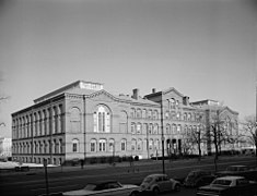
The United States Congress established the United States Department of Agriculture in 1862 during the Civil War.[53] Designed by Adolf Cluss and Joseph von Kammerhueber, the United States Department of Agriculture Building (No. 25 on the map), was constructed in 1867–1868 north of B Street SW within a 35-acre site on the Mall.[54]
Some of the image captions in this section may require cleanup to comply with Wikipedia guidelines for succinctness. (April 2023) |
-
 1863 photograph of the National Mall and vicinity during the Civil War, looking west towards the U.S. Botanical Garden, Washington City Canal, Gas Works, railroad tracks, Washington Armory, and Armory Square Hospital buildings. The Smithsonian Institution Building, the uncompleted Washington Monument (behind the Smithsonian's building), and the Potomac River are in the background.
 -
 The Victorian landscaping and architecture of the Mall looking east from the top of the Washington Monument, showing the influence of the Downing Plan and Adolph Cluss on the National Mall circa 1904. The Department of Agriculture Building, and above it, "The Castle", are in the foreground. A railroad route leading to a shed attached to the Baltimore and Potomac Railroad station (not visible) crosses the Mall behind the Arts and Industry Building, the Army Medical Center, and the Armory.
 -
 View looking north of the National Mall with the Treasury Building in the background in April 1865.
 -
 View the National Mall with its livestock and the Treasury Building in the background in April 1865.


After the Civil War ended, the Department of Agriculture started growing experimental crops and demonstration gardens on the Mall. These gardens extended from the department's building near the south side of the Mall to B Street NW (the northern boundary of the Mall). The building was razed in 1930.[53] In addition, greenhouses belonging to the U.S. Botanical Garden (No. 16 on the map) appeared near the east end of the Mall between the Washington City Canal and the Capitol (later between 1st and 3rd Streets NW and SW).[48]
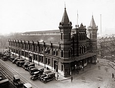
Originating during the early 1800s as a collection of market stalls immediately north of the Washington City Canal and the Mall, the Center Market (No. 19 on the map), which Adolf Cluss also designed, opened in 1872 soon after the canal closed. Located on the north side of Constitution Avenue NW, the National Archives now occupies the Market's site.[55][56]
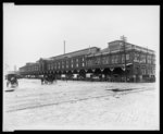
During that period, railroad tracks crossed the Mall on 6th Street, west of the Capitol.[34] Near the tracks, several structures were built over the years. The Baltimore and Potomac Railroad station (B on the map) rose in 1873 on the north side of the Mall at the southwest corner of 6th Street and B Street NW (now the site of the west building of the National Gallery of Art).[57]
In 1881, the Arts and Industries Building (No. 34 on the map), known originally as the National Museum Building, opened on the north side of B Street SW to the east of "The Castle". Designed in 1876 by Adolf Cluss and his associates, the building is the second oldest still standing on the National Mall (proper).[58]
In 1887, the Army Medical Museum and Library, which Adolf Cluss designed in 1885, opened on the Mall at northwest corner of B Street SW and 7th Street SW.[59][60] The Smithsonian Institution's Hirshhorn Museum now occupies the site of the building, which was demolished in 1968.[60]
Meanwhile, in order to clean up the Potomac Flats and to make the Potomac River more navigable, in 1882 Congress authorized the Army Corps of Engineers to dredge the river. The Corps used the sediment removed from the shipping channel to fill in the flats. The work started in 1882 and continued until 1911, creating the Tidal Basin and 628 new acres of land. Part of the new land, which became West Potomac Park, expanded the Mall southward and westward (see 1893 map above).[41][61]
-
 Looking east from the top of the Washington Monument towards the United States Capitol in the summer of 1901. The Mall exhibited the Victorian-era landscape of winding paths and random plantings that Andrew Jackson Downing designed in the 1850s
 -
 The Armory as a hospital during the Civil War
 -
 Department of Agriculture Building (circa 1895)
 -
 Center Market circa 1875, looking northwest from The Mall
 -
 Center Market between 1910 and 1930, looking southwest from 7th Street NW (at left)
 -
 Arts and Industries Building, looking southwest (March 2017)
 -
 Baltimore and Potomac Railroad station, looking southwest from 6th Street NW (at bottom and left)
 -
 Army Medical Museum and Library, looking northeast from Independence Avenue SW


_-_NARA_-_512817.jpg)


.jpg)

McMillan Plan edit

In 1902, the McMillan Commission's plan, which was partially inspired by the City Beautiful Movement and which purportedly extended L'Enfant's plan, called for a radical redesign of the Mall that would replace its greenhouses, gardens, trees, and commercial/industrial facilities with an open space.[34][48][62] The plan differed from L'Enfant's by replacing the 400 feet (120 m) wide "grand avenue" with a 300 feet (91 m) wide vista containing a long and broad expanse of grass.
Four rows of American elm trees (Ulmus americana) planted fifty feet apart between two paths or streets would line each side of the vista. Buildings housing cultural and educational institutions constructed in the Beaux-Arts style would line each outer path or street, on the opposite side of the path or street from the elms.[34][48][62][63][64][65]
In subsequent years, the vision of the McMillan plan was generally followed with the planting of American elms and the layout of four boulevards down the Mall, two on either side of a wide lawn.[63][66][67] In accordance with a plan that it completed in 1976, the NPS converted the two innermost boulevards (Washington Drive NW and Adams Drive SW) into gravel walking paths.[63] The two outermost boulevards (Madison Drive NW and Jefferson Drive SW)) remain paved and open to vehicular traffic.[63]
Temporary war buildings edit
During World Wars I and II, the federal government constructed a number of temporary buildings (tempos) on the Mall, disrupting the area's planned layout. Most of these buildings were in two clusters: one near the Lincoln Memorial Reflecting Pool and the other on the National Mall (proper) in the vicinity of 4th through 7th Streets NW and SW.[68][69][70]
World War I edit

The United States entered World War I in April 1917.[72] By 1918, a row of tempos designated from north to south as Buildings A, B, and C had stretched across the Mall along the east side of the former railroad route on 6th Street. The smokestacks of the buildings' centrally-located power plant were set apart to preserve the view of the Washington Monument from the Capitol building.[69][71][73] Soon afterwards, the government constructed Buildings D, E and F to the east and west of the row.[69][73]
Around 1921 (when the United States and Germany signed the U.S.–German Peace Treaty, thus formally ending the war between the two nations),[74] the government demolished Buildings A and B. The remaining tempos held offices of several agencies belonging to the Agriculture, Commerce, Treasury and War Departments for a number of years after the war ended.[69][73][75]
The government then slowly dismantled most of the tempos that had remained within the Mall (proper), removing the power plant and nearby buildings by 1936.[76] Among those removed was Building C, which the government demolished between 1933 and 1936.[77]
By 1937, the government had removed all of the World War I tempos that had been within the National Mall (proper) except for Building E, thus largely restoring the Mall's central vista.[66] However, another World War I tempo, which the government constructed south of the Mall in 1919 between 14th Street SW and the Tidal Basin as the Liberty Loan Building, remained standing in 2019 while housing the Treasury Department's Bureau of the Fiscal Service.[78][79]

In 1918, contractors for the United States Navy's Bureau of Yards and Docks constructed the Main Navy and Munitions Buildings along nearly a third of a mile of the south side of Constitution Avenue (then known as B Street), from 17th Street NW to 21st Street NW.[79][81][82][83] Although the Navy intended the buildings to provide temporary quarters for the United States military during World War I, the reinforced concrete structures remained in place until 1970.[79][81][82] After their demolition, much of their former sites became Constitution Gardens, which was dedicated in 1976.[82][84]
World War II edit
During World War II, the government constructed a larger set of temporary buildings on the Mall in the area of the former World War I tempos, along the south side of Constitution Avenue between 12th and 14th Streets NW, on the west side of the Washington Monument grounds, along the entire length of the south side of the Lincoln Memorial Reflecting Pool and between the Reflecting Pool and the Main Navy and Munition buildings on the Pool's north side. Numbers identified new buildings built on the Monument grounds, while letters identified the remainder. The government also built dormitories, residence halls and facilities for dining and recreation south of the eastern half of the Mall and within the part of West Potomac Park that lay south of the Mall's western half.[70][85]
The government progressively demolished all of the World War II tempos beginning in 1964.[79] After the government removed the Main Navy and Munitions buildings in 1970, much of their former sites became Constitution Gardens, which was dedicated in 1976.[82][79][84]
Later history edit
.jpg)
The planting of American elm trees (Ulmus americana) on the National Mall following the McMillan Plan started in the 1930s between 3rd and 14th Streets at the same time that Dutch Elm Disease (DED) began to appear in the United States. Concern was expressed about the impact that DED could have on these trees.[86]

DED first appeared on the Mall during the 1950s and reached a peak in the 1970s. The NPS has used a number of methods to control this fungal epidemic, including sanitation, pruning, injecting trees with fungicide and replanting with DED-resistant American elm cultivars (see Ulmus americana cultivars). The NPS cloned one such cultivar ('Jefferson') from a DED-resistant tree growing near a path on the Mall in front of the Freer Gallery of Art, near the Smithsonian Institution Building ("The Castle").[87]
The NPS has combated the disease's local insect vector, the smaller European elm bark beetle (Scolytus multistriatus), by trapping and by spraying with insecticides. Soil compaction and root damage by crowds and construction projects also adversely affect the elms.[86]
On October 15, 1966, the NPS listed the National Mall on the National Register of Historic Places.[88] In 1981, the NPS prepared a National Register nomination form that documented the Mall's boundaries, features and historical significance.[6]

From the 1970s to 1994, a fiberglass model of a triceratops named Uncle Beazley stood on the Mall in front of the National Museum of Natural History. The life-size statue, which is now located at the National Zoological Park (the National Zoo) in Northwest Washington, D.C., was donated to the Smithsonian Institution by the Sinclair Oil Corporation. The statue, which Louis Paul Jonas created for Sinclair's DinoLand pavilion at the 1964 New York World's Fair, was named after a dinosaur in Oliver Butterworth's 1956 children's book, The Enormous Egg, and the 1968 televised movie adaptation in which the statue appeared.[89]

In 2003, the 108th United States Congress enacted the Commemorative Works Clarification and Revision Act. This Act prohibits the siting of new commemorative works and visitor centers in a designated reserve area within the cross-axis of the Mall.[90]
In October 2013, a two-week federal government shutdown closed the National Mall and its museums and monuments.[91] However, when a group of elderly veterans tried to enter the National World War II Memorial during the shutdown's first day, the memorial's barricades were removed.[92] The NPS subsequently announced that the veterans had a legal right to be in the memorial and would not be barred in the future.[93] During the shutdown's second week, the NPS permitted an immigration rally and concert to take place on the Mall.[94]
On December 8, 2016, the NPS listed on the National Register of Historic Places an increase in the National Mall Historic District's boundary to encompass an area bounded by 3rd Street, NW/SW, Independence Avenue, SW, Raoul Wallenberg Place, SW, the CSX Railroad, the Potomac River, Constitution Ave., NW, 17th Street, NW, the White House Grounds and 15th Street, NW. The listing's registration form, which contained 232 pages, described and illustrated the history and features of the historic district's proposed expanded area.[2]
Demolished or moved structures edit
- Washington City Canal, covered over by Constitution Avenue NW, 3rd Street NW, and SW and Canal Street SW (now Washington Street SW).
- Baltimore and Potomac Railroad Station, closed in 1907 when Union Station opened.
- United States Department of Agriculture Building, demolished in 1930.
- Center Market, replaced in 1931 by the National Archives Building.
- Armory Square Hospital/Armory, replaced in 1976 by the National Air and Space Museum.
- Army Medical Museum and Library, demolished in 1968; replaced by the Hirshhorn Museum
- Temporary Main Navy and Munitions Buildings, built in 1918, demolished in 1970; replaced by Constitution Gardens.
- Uncle Beazley, moved in 1994 to the National Zoo.
Other attractions nearby edit

Other attractions within walking distance of the National Mall (proper) include:
East of the Capitol edit
Northeast of the National Mall (proper) edit
- Holodomor Genocide Memorial
- Japanese American Memorial to Patriotism During World War II
- National Postal Museum
- Robert A. Taft Memorial
- Union Station
North of the National Mall (proper) edit

- Ford's Theatre
- George Gordon Meade Memorial
- Inlay of L'Enfant's plan for the federal capital city in Freedom Plaza
- National Archives
- National Building Museum
- National Law Enforcement Museum
- National Law Enforcement Officers Memorial
- National Museum of Women in the Arts
- National Portrait Gallery
- National Theatre
- Old Post Office Building and Clock Tower
- Pershing Park and National World War I Memorial
- Smithsonian American Art Museum
- United States Navy Memorial
Northwest of the National Mall (proper) edit


.jpg)
- Albert Einstein Memorial
- Boy Scout Memorial
- Butt–Millet Memorial Fountain
- Enid Haupt Fountains[95]
- First Division Monument
- German-American Friendship Garden
- Interior Museum
- John F. Kennedy Center for the Performing Arts
- National Christmas Tree
- Second Division Memorial
- Settlers of the District of Columbia Memorial[96]
- Statues of the Liberators
- The Ellipse
- Theodore Roosevelt Island
- U.S. Capitol Gatehouses and Gateposts
- White House (on a line directly north of the Washington Monument)
- Zero Milestone
West of the National Mall (proper) edit
- Arlington Memorial Bridge
- The Arts of War and The Arts of Peace statues at the eastern approach to the Arlington Memorial Bridge
- Marine Corps War Memorial
- Netherlands Carillon
Southwest of the National Mall (proper) edit

- Arlington House, The Robert E. Lee Memorial
- Arlington National Cemetery
- Bureau of Engraving and Printing
- Franklin Delano Roosevelt Memorial
- George Mason Memorial
- Jefferson Memorial
- Lady Bird Johnson Park
- Lyndon Baines Johnson Memorial Grove on the Potomac
- Martin Luther King, Jr. Memorial
- Tidal Basin
- United States Forest Service Museum[97]
- United States Holocaust Memorial Museum
- Women in Military Service for America Memorial
South of the National Mall (proper) edit
.jpg)
Usage edit
In combination with the other attractions in the Washington Metropolitan Area, the National Mall makes the nation's capital city one of the most popular tourist destinations in the country. It has several other uses in addition to serving as a tourist focal point.
Protests and rallies edit

The National Mall's status as a vast, open expanse at the heart of the capital makes it an attractive site for protests and rallies of all types. One notable example was the 1963 March on Washington for Jobs and Freedom, a political rally during the Civil Rights Movement, at which Martin Luther King Jr. delivered his speech "I Have a Dream".
The largest officially recorded rally was the Vietnam War Moratorium Rally on October 15, 1969. However, in 1995, the NPS issued a crowd estimate for the Million Man March with which an organizer of the event, Nation of Islam leader Louis Farrakhan, disagreed.[98][99] The next year, a committee of the 104th United States Congress provided no funds for NPS crowd-counting activities in Washington, D.C., when it prepared legislation making 1997 appropriations for the U.S. Department of the Interior.[98][100]
As a result, the NPS has not provided any official crowd size estimates for Mall events since 1995.[98][99][101] The absence of such an official estimate fueled a political controversy following the presidential inauguration of Donald Trump in 2017 (see: Inauguration of Donald Trump crowd size).[102]
On April 25, 2004, the March for Women's Lives filled the Mall.[103] On January 27, 2007, tens of thousands of protesters opposed to the Iraq War converged on the Mall (see: January 27, 2007 anti-war protest), drawing comparisons by participants to the Vietnam War protest.[104]
On June 12, 2018, the National Hockey League's Washington Capitals staged a rally on the Mall after parading through the city to celebrate the franchise's first Stanley Cup championship victory. Tens of thousands of fans reportedly joined the beer-soaked event.[105]
Presidential inaugurations edit

During presidential inaugurations, people without official tickets gather at the National Mall. Normally, the Mall between 7th and 14th Streets NW is used as a staging ground for the parade.[106] On December 4, 2008, the Presidential Inaugural Committee (see: United States presidential inauguration organizers) announced, "for the first time, the entire length of the National Mall will be opened to the public so that more people than ever before will be able to witness the swearing-in of the president from a vantage point in sight of the Capitol."[107] The committee made this arrangement because of the massive attendance – projected to be as many as 2 million people – that it expected for the first inauguration of Barack Obama on January 20, 2009.
Despite the arrangement, a throng of people seeking access to the event climbed and then removed temporary protective fences around the Smithsonian's Mary Livingston Ripley Garden, six blocks from the site at which Obama took his inaugural oath. Hordes then trampled the garden's vegetation and elevated plant beds when entering and leaving the event.[108] Others could not find a way to enter the Mall in time to view the ceremony.
More than a thousand people with purple tickets missed the event while being stranded in the I-395 Third Street Tunnel beneath the Mall after police directed them there (see Purple Tunnel of Doom).[109] Terrance W. Gainer, the Sergeant at Arms of the United States Senate, stated that it appeared that the stranding had occurred because there were more bulky people in coats than the event's purple section could accommodate.[110] The Joint Congressional Committee on Inaugural Ceremonies subsequently announced that ticket holders that were not admitted would receive copies of the swearing-in invitation and program, photos of Obama and Vice President Joe Biden, and a color print of the ceremony.[111]
Other events and recreational activities edit
The National Mall has long served as a spot for jogging, picnics, and light recreation for the Washington population. The Smithsonian Carousel, located on the Mall in front of the Arts and Industry Building, is a popular attraction. The Allan Herschell Company built the carousel, which arrived at Gwynn Oak Park near Baltimore, Maryland, in 1947. The carousel was moved to the Mall in 1981 and now operates seasonally.[11]
Annual events edit
A number of large free events recur annually on the Mall.[112] A kite festival, formerly named the "Smithsonian Kite Festival" and now named the "Blossom Kite Festival", usually takes place each year on the Washington Monument grounds during the last weekend of March as part of the National Cherry Blossom Festival. The event's organizers cancelled the 2020 kite festival, which they had earlier scheduled to take place on the Washington Monument grounds on Saturday, March 28, because of concerns related the ongoing coronavirus pandemic.[113]
An Earth Day celebration often takes place on the Mall around April 22.[114] A week-long series of rallies, exhibits, observances and performances occurred on the Mall from April 17 to April 25, 2010, to commemorate Earth Day's 40th anniversary.[115] The final day's events featured performances by Sting, Mavis Staples, the Roots, John Legend and others.[116]

The 2012 Earth Day rally, which featured music, entertainment, celebrity speakers and environmental activities, took place on the Mall during a rainy day on Sunday, April 22. Cheap Trick, Dave Mason, Kicking Daisies, Sting, John Legend, Joss Stone, the Roots, Mavis Staples, Jimmy Cliff, Bob Weir and the Explorers Club performed and Congressmen John Dingell and Edward Markey spoke.[117] In 2013, an "Earth Month" at Washington's Union Station replaced the Mall's Earth Day event.[118] On April 19, 2015, a "Global Citizen" Earth Day concert featured performances on the Washington Monument grounds by Usher, My Morning Jacket, Mary J. Blige, Train and No Doubt.[119]
The National Symphony Orchestra presents each year its National Memorial Day Concert on the west lawn of the United States Capitol during the evening of the Sunday before Memorial Day (the last Monday of May).[120] The National Gallery of Art hosts a Jazz in the Garden series each year in the museum's Sculpture Garden on Friday evenings from late May through August.[121]
Components of the United States Navy Band, the United States Air Force Band, the United States Marine Band and the United States Army Band perform on the west steps of the United States Capitol on Monday, Tuesday, Wednesday and Friday evenings, respectively, during June, July and August.[122][123] The Marine Band repeats each Wednesday Capitol performance on the following evening (Thursday) at the Sylvan Theater on the grounds of the Washington Monument.[123] Components of U.S. military bands also provide evening concerts at the World War II Memorial from May through August.[124]
The Smithsonian Folklife Festival takes place on the Mall each year for two weeks around Independence Day (July 4).[125][126] On that holiday, the A Capitol Fourth concert takes place in the late afternoon and early evening on the west lawn of the Capitol.[127] This and other Independence Day celebrations on and near the Mall end after sunset with a fireworks display between the Washington Monument and the Lincoln Memorial.[128]
The National Symphony Orchestra presents each year its Labor Day Capitol Concert on the west lawn of the United States Capitol during the evening of the Sunday before Labor Day (the first Monday of September).[129]
Other events edit

On April 9, 1939, singer Marian Anderson gave an Easter Sunday concert at the Lincoln Memorial after the Daughters of the American Revolution (DAR) denied a request by Howard University for her to give an Easter performance at the DAR's nearby racially segregated Constitution Hall (see: Marian Anderson's 1939 Lincoln Memorial concert). The event, which 75,000 people attended, occurred after President Franklin D. Roosevelt gave his assent for the performance.[130][131]
The 1976 United States Bicentennial celebration provided the motivation for planning to accommodate large numbers of expected visitors to the National Mall. A number of major memorials were added to the Mall throughout that period.[132] On May 21, 1976, Constitution Gardens was dedicated.[133] On July 1, the Smithsonian National Air and Space Museum opened.[134] On July 4, the Bicentennial fireworks display on the Mall attracted one million viewers, making it second only to the 1965 presidential inauguration of Lyndon B. Johnson as the largest event in the Mall's history up to that time.[135]
On Sunday, October 9, 1979, Pope John Paul II celebrated Mass on the National Mall during a visit to Washington.[136] The celebration took place after an appellate court denied a motion for an injunction that atheists Madalyn Murray O'Hair and Jon Garth Murray had filed to prevent the event from occurring.[137]
From 1980 through 1982, the Beach Boys and the Grass Roots performed Independence Day concerts on the Mall, attracting large crowds.[138][139][140] However, in April 1983, Secretary of the Interior James G. Watt, banned Independence Day concerts on the Mall by such groups.
Watt said that "rock bands" that had performed on the Mall on Independence Day in 1981 and 1982 had encouraged drug use and alcoholism and had attracted "the wrong element", who would mug individuals and families attending any similar events in the future.[139] Watt then announced that Las Vegas crooner Wayne Newton, a friend and supporter of President Ronald Reagan and a contributor to Republican Party political campaigns, would perform at the Mall's 1983 Independence Day celebration.[139][141]
During the ensuing uproar, Rob Grill, lead singer of the Grass Roots, stated that he felt "highly insulted" by Watt's remarks, which he called "nothing but un-American".[139] The Beach Boys stated that the Soviet Union, which had invited them to perform in Leningrad in 1978, "obviously .... did not feel that the group attracted the wrong element".[139] Vice President George H. W. Bush said of the Beach Boys, "They're my friends and I like their music".[139]
On July 3, 1983, thousands attended a heavily policed "Rock Against Reagan" concert that the hardcore punk rock band, Dead Kennedys, performed on the Mall in response to Watt's action.[142] When Newton entered an Independence Day stage on the Mall on July 4, members of his audience booed.[143][144] Watt apologized to the Beach Boys, First Lady Nancy Reagan apologized for Watt, and in 1984 the Beach Boys gave an Independence Day concert on the Mall to an audience of 750,000 people.[143][145]

On September 4, 2003, Britney Spears, Mary J. Blige, Aretha Franklin, Aerosmith and others performed in a nationally televised "NFL Kickoff Live from the National Mall Presented by Pepsi Vanilla" (see: Pre-game concerts for National Football League kickoff game).[146] Preceded by a three-day National Football League "interactive Super Bowl theme park", the event had primarily commercial purposes, unlike earlier major activities on the Mall. Three weeks later, the United States Senate overwhelmingly passed legislation that, when enacted into law, limited displays of commercial sponsorship on the Mall.[147]
On July 7, 2007, one leg of Live Earth was held outdoors at the National Museum of the American Indian on the Mall. Former Vice President Al Gore presented, and artists such as Garth Brooks and Trisha Yearwood performed.[148]
Occurring once every two to three years on the Mall in the early fall from 2002 to 2009,[149] the U.S. Department of Energy Solar Decathlon displayed solar-powered houses that competitive collegiate teams designed, constructed and operated.[150][151] Igniting a controversy, the Department of Energy (DOE) decided to move the 2011 Decathlon off the Mall, claiming that this would support an effort to protect, improve and restore the park.[152] Federal officials stated that heavy equipment that had placed two-story houses on the Mall during earlier Decathlons had cracked walkways and killed grass to a greater extent than had most other Mall events.[153]
On February 4, 2011, a Washington Post editorial criticized attempts to have President Obama restore the Decathlon to the Mall.[154] Nevertheless, by February 12, 2011, at least thirteen U.S. senators had signed a letter asking the DOE to reconsider its decision.[153] On February 23, 2011, the DOE and the Department of the Interior announced that the 2011 Solar Decathlon would take place along Ohio Drive southeast of the Franklin Delano Roosevelt Memorial in West Potomac Park.[155] The event took place in the Park from September 23 through October 2, 2011.[151][156] The 2013 Decathlon took place in Irvine, California, instead of Washington.[157]
From 2003 to 2013, the National Book Festival took place on the Mall each year in late September or early October.[158] However, the event moved to the Walter E. Washington Convention Center in 2014 because the NPS became concerned about the damage that pedestrians had inflicted on the Mall's lawn during previous Festivals.[159]
A four-day exhibition took place each year on the Mall during Public Service Recognition Week (the first full week of May) until 2010. Government agencies participating in the event sponsored exhibits that displayed the works of public employees and that enabled visitors to learn about government programs and initiatives, discuss employee benefits, and interact with agency representatives.[160] However, the 2011 United States federal budget (Public Law 112-10), which was belatedly enacted on April 15, 2011, contained no funding for that year's event, forcing the event's cancellation.[161] The event did not take place in 2012.[162]
On June 12, 2010, Tareq and Michaele Salahi, a couple under investigation for allegedly crashing a White House state dinner for the prime minister of India in November 2009 (see: 2009 U.S. state dinner security breaches), hosted an America's Polo Cup match between the United States and India on the Mall, charging $95 per person for admission.[163] A spokesman for the Embassy of India stated that neither the Embassy nor the government of India had any association with the event.[163] Reports of the event stated that the players who represented India were actually of Pakistani origin and were from Florida.[164]

The inaugural USA Science and Engineering Festival Expo took place on the National Mall and surrounding areas on October 23 and 24, 2010. More than 1,500 free interactive exhibits reportedly drew about 500,000 people to the event,[165] which had over 75 performances.[166] The second Expo took place on April 28–29, 2012, in the Walter E. Washington Convention Center.[167]
On Veterans Day, November 11, 2014, Bruce Springsteen, Eminem, Rihanna, Metallica, Carrie Underwood, Dave Grohl, the Zac Brown Band and other pop entertainers performed on the Mall during a free evening Concert for Valor honoring veterans and their families. Attendance was in the hundreds of thousands, making it one of the biggest events on the Mall for the year.[168]
The annual Screen on the Green movie festival took place on the Mall on Monday nights during July and August for 17 years until 2015. Free classic movies were projected on large portable screens and typically drew crowds of thousands of people. Organizers cancelled the event in 2016 when the event's sponsors (HBO and Comcast) terminated their support, stating that they needed their resources for other projects.[169]
During October 2020, artist Suzanne Brennan Firstenberg installed 267,080 white flags within a 4 acres (1.6 ha) site at the D.C. Armory Parade Grounds near Washington's Robert F. Kennedy Memorial Stadium to temporarily memorialize the lives lost in the United States during the COVID-19 pandemic.[170] She recreated her memorial on the Washington Monument grounds during September 2021 when covering for three weeks a 20 acres (8.1 ha) area with 700,000 white flags.[171]
From September 29, 2023, until October 1, 2023, the National Mall hosted the third global World Culture Festival, featuring performances from around the world and speeches from global leaders.[172]
Improvements and future plans edit
National Mall Plan edit
From 2006 through 2010, the NPS conducted a public process that created a plan for the future of the National Mall.[27] On July 13, 2010, the NPS issued in the Federal Register a notice of availability of a final environmental impact statement (EIS) for the National Mall Plan.[173] The two-volume final EIS responded to comments and incorporated changes to a draft EIS for the Plan.[174]

.jpg)
On November 9, 2010, the NPS and the Department of the Interior issued a Record of Decision (ROD) that completed the planning process.[27][175][176][177] The ROD contains a summary of the selected alternative, which is the basis for the Plan, together with mitigation measures developed to minimize environmental harm; other alternatives considered; the basis for the decision in terms of planning objectives and the criteria used to develop the preferred alternative; a finding of no impairment of park resources and values; the environmentally preferable alternative; and the public and agency involvement.[178][179]
The Plan proposed several changes to the Mall. The NPS would construct a vast expanse of paved surface in Union Square at the east end of the Mall to accommodate demonstrations and other events by reducing the size of the Capitol Reflecting Pool or by replacing the pool with a fountain or other minor water feature. Additional proposed changes included the replacement of the Sylvan Theater on the Washington Monument grounds with a facility containing offices, restaurants, and restrooms, as well as the replacement of an open space near the east end of Constitution Gardens with a multipurpose visitor facility containing food service, retail, and restrooms.[27][175][176][177]
On December 2, 2010, the National Capital Planning Commission (NCPC) unanimously approved the final National Mall Plan at a public hearing.[180] The NCPC's approval allowed the NPS to move forward with implementation of the Plan's recommendations.[27][177][178][180]
On March 1, 2012, the NCPC discussed a proposal that, when implemented, reduced the Mall's green space by widening and paving most of the north–south walkways that cross the Mall between Seventh and Fourteenth Streets. The project also replaced with gravel large areas of grass that were located near the Smithsonian Metro Station and the National Gallery of Art's Sculpture Garden.[181]
On September 8, 2011, the Trust for the National Mall[182] and the NPS announced an open competition for a redesign of the spaces on the National Mall that Union Square, the Sylvan Theater grounds and the Constitution Gardens lake now occupy.[183] Former First Lady of the United States Laura Bush agreed to be the honorary co-chair of a drive to raise funds for the three projects.[183]
On April 9, 2012, the Trust for the National Mall announced the ideas for the redesign of Union Square, the Sylvan Theater grounds and Constitution Gardens lake area that finalists in the competition had submitted. The Trust asked the public to submit online comments that the competition jury would consider when evaluating each design.[184] The Trust announced the winners of the competition on May 2, 2012. Groundbreaking for the first project was expected to take place by 2014, with the first ribbon-cutting ceremony by 2016.[185]
On October 1, 2015, the NCPC approved the preliminary and final site and building plans that the NPS had submitted for the first phase rehabilitation of Constitution Gardens. Plans included the relocation and rehabilitation of the Lockkeeper's House, C & O Canal Extension, a new entry plaza at the corner of Constitution Avenue and 17th Street, NW, landscaping, a meadow and pollinator habitat and a new perimeter garden wall. A temporary path would connect to an existing plaza located at the eastern end of Constitution Garden's lake.[186]
The NPS began to implement the first phase rehabilitation of Constitution Gardens in 2017. A Park Service contractor moved the Lockkeeper's House, C & O Canal Extension, southward and westward away from Constitution Avenue, NW and 17th Street, NW while retaining the structure's east–west orientation.[43][187] The NPS restored the building's exterior to the conditions that had existed before the building was modified during 1915 and earlier years. The NPS also replaced the structure's brick chimneys, thus restoring the building to its original 1800s appearance. The building reopened temporarily in late August 2018 and permanently on September 13 of that year.[42][43][188] The structure now serves in its new location as an NPS education center.[42][43]
Reconstruction and restoration edit
From 2010 to 2012, NPS contractors rebuilt the aging Lincoln Memorial Reflecting Pool, which had first been constructed in the early 1920s and whose water had come from the pipes that supply Washington, D.C., with its drinking water. As a result of the project, the pool now receives filtered water from the Tidal Basin through a high-density polyethylene (HDPE) pipeline.[189]
The NPS then began a four-year restoration of the portion of the central axis of the Mall that lies between 3rd Street and 14th Street.[190] By 2016, the restoration project had completely replaced the deteriorated and weedy turf that had previously covered much of that part of the Mall with a new cover containing soil, fescue (Festuca) and Kentucky bluegrass (Poa pratensis).[191]
-
 Lincoln Memorial Reflecting Pool before reconstruction (April 2010)
 -
 Pool undergoing reconstruction (June 2011)
 -
 Pool undergoing reconstruction (December 2011)
 -
 Pool after reconstruction (May 2016)
 -
 Axis of National Mall before restoration (July 2012)
 -
 Axis undergoing restoration (April 2015)
 -
 Axis undergoing restoration (October 2015)
 -
 Axis after restoration (September 2016)
 -
 Aerial view of National Mall, Looking West
.jpg)


Transportation edit
Public transportation edit

The National Mall is accessible via the Washington Metro, with the Smithsonian station located on the south side of the Mall, near the Smithsonian Institution Building between the Washington Monument and the United States Capitol.[192] The Federal Triangle, Archives, Judiciary Square and Union Station Metro stations are also located near the Mall, to the north.[193] The L'Enfant Plaza, Federal Center Southwest and Capitol South Metro stations are located several blocks south of the Mall.[194] Metrobus and the DC Circulator make scheduled stops near the Mall.[195]
Bicycles edit
The NPS provides parking facilities for bicycles near each of the major memorials as well as along the National Mall.[196] From March to October, an NPS concessionaire rents out bicycles at the Thompson Boat Center, located near the intersection of Virginia Avenue NW and Rock Creek and Potomac Parkway, 1 mile (1.6 km) north of the Lincoln Memorial along the Potomac River-Rock Creek Trail.[196][197] The first two of five approved Capital Bikeshare stations opened on the National Mall on March 16, 2012, shortly before the start of the 2012 National Cherry Blossom Festival.[198]
The National Mall is the official midpoint of the East Coast Greenway, a 2,900 mile–long system of shared-use bicycle trails linking Calais, Maine, with Key West, Florida.[199]
Electric scooters and Segways edit
The use of an electric scooter or a Segway falls under the NPS definition of recreational use of a self-propelled vehicle. People without identified disabilities can only use such vehicles on park roadways. NPS rules, therefore, prohibit people without disabilities from using electric scooters and Segways on sidewalks and paths within the National Mall and its memorials.[200][201]
Several companies rent out electric scooters within the District of Columbia. However, the National Mall is outside of those companies' service areas. Some such companies, therefore, charge fines for people who end their rides on the Mall. Others do not allow people to end their trips until they have left the area.[201]
Pedicabs edit
The NPS licenses pedicab drivers to provide transportation and tours of the National Mall through its Commercial Use Authorization program.[202]
Motor vehicle parking edit

General visitor parking is available along Ohio Drive SW, between the Lincoln and Thomas Jefferson Memorials. Bus parking is available primarily along Ohio Drive, SW, near the Lincoln and Thomas Jefferson Memorials, and along Ohio Drive SW, in East Potomac Park. There is limited handicapped parking at the Franklin Delano Roosevelt and World War II Memorials and near the Washington Monument and the Thomas Jefferson, Lincoln, Korean War Veterans, and Vietnam Veterans Memorials; otherwise, parking is extremely scarce in and near the Mall.[203]
In April 2017, the NPS awarded a contract for the installation of parking meters on streets and in parking areas on the Mall. On June 12, 2017, the NPS and the District of Columbia Department of Public Works began to enforce metered parking on approximately 1,100 parking spaces in which motorists could previously park without charge.[203][204]
Weather and climate edit
.jpg)
On July 16, 2016, speakers and musicians participated in a gathering of thousands of evangelicals during a Together 2016 rally on the Mall.[205][206] Although the event was originally scheduled to conclude at 9 p.m., it ended at 4 p.m. due to excessive heat. Officers reportedly responded to 350 medical calls for heat-related injuries. The large number of people who lost consciousness because of heat syncope overwhelmed emergency medical technicians.[205][207]
On July 1, 2021, an EF1 tornado formed in Arlington County, Virginia at 8:59 p.m., crossed the Potomac River near the Theodore Roosevelt Bridge, and traveled eastward along the National Mall before dissipating near 16th Street NW and Constitution Avenue south of the White House and The Ellipse, 4.4 mi (7 km) from where it had started. Its maximum winds were 90 mph (145 km/h), and it was as wide as 125 yards (114 m). The National Weather Service reported that wind damage to trees on the Mall "was prominent from 23rd St NW east for 0.75 mi (1.2 km) to near 16th Street NW south of The Ellipse". The weather service stated that the tornado lifted up and twisted temporary fencing installed on the Mall for the upcoming July 4 Independence Day celebration. The fencing landed in a "mangled and haphazard manner" before the twister dissipated at 9:05 p.m.[208]
| ||||||||||||||||||||||||||||||||||||||||||||||||||||||||||||||||||||||||||||||||||||||||||||||||||||||||||||||||||||||||||||
In popular culture edit
The National Mall is a common backdrop and setting for films, television shows, and other forms of media. The Mall is the setting for a famous scene in Forrest Gump, in which Forrest gives a speech during the 1963 March on Washington at the Lincoln Memorial. The film National Treasure is set on and around the National Mall. The Mall is also a common setting in several superhero movies. Spider-Man: Homecoming, Captain America: The Winter Soldier, and Wonder Woman 1984 all have prominent scenes on the Mall. The comedic film Wedding Crashers is set in Washington, D.C., and has scenes on the Mall. Additionally, the mall is a common feature of the Netflix series House of Cards. The Mall is also a setting of season three, episode three of the show Family Guy, as well as season 17, episode 11 of the show, nicknamed "Trump Guy".
News organisations that present live coverage or recorded programs from Washington often use the Mall as a backdrop.
See also edit
- National Register of Historic Places listings in Washington, D.C.
- Operation Fast Forward
- Capitol Mall, a similar but smaller parkway situated in front of California State Capitol modeled on the National Mall
- Architecture of Washington, D.C.
References edit
- ^ "National Register of Historic Places: NPS Focus". National Park Service. Archived from the original on July 25, 2008. Retrieved July 8, 2010.
- ^ a b "District of Columbia: National Mall Historic District (Boundary Increase and Additional Documentation), Bounded by 3rd St. NW-SW, Independence Ave. SW, Raoul Wallenberg Pl. SW, CSX RR, Potomac R., Constitution Ave. NW, Washington, 16000805, Listed 12/8/2016". National Register of Historic Places Program: Weekly List of Actions Taken on Properties: 11/28/2016 through 12/2/2016. National Park Service. December 9, 2016. Archived from the original on December 20, 2016. Retrieved December 20, 2016.
- ^ Robinson, Judith H.; Gasparini, Daria; Kerr, Tim (May 31, 2016). "National Mall Historic District – Boundary Increase/Additional Documentation (Final backcheck)". United States Department of the Interior: National Park Service: National Register of Historic Places Registration Form. National Park Service. Archived from the original on October 12, 2016. Retrieved October 12, 2016.
- ^ a b "The National Parks: Index 2012-2016" (PDF). National Park Service. p. 44. Archived (PDF) from the original on December 26, 2017. Retrieved December 26, 2017.
- ^ "National Mall Frequently Asked Questions". National Park Service. October 28, 2008. Archived from the original on May 7, 2010. Retrieved April 18, 2010.
- ^ a b c d Pfanz, Donald C. (February 11, 1981). "National Register of Historic Places Inventory Nomination Form: National Mall". National Park Service. Retrieved March 17, 2010. "Archived copy" (PDF). Archived from the original on December 23, 2015. Retrieved June 12, 2017.
{{cite web}}: CS1 maint: archived copy as title (link) CS1 maint: bot: original URL status unknown (link) - ^ a b c d "Foundation statement for the National Mall and Pennsylvania Avenue National Historic Park" (PDF). National Mall Plan. National Park Service. pp. 6–10. Archived (PDF) from the original on December 26, 2017. Retrieved December 26, 2017.
The National Mall stretches from the grounds of the U.S. Capitol west to the Potomac River, and from the Thomas Jefferson Memorial north to Constitution Avenue.
- ^ Numbers preceding names of landmarks correspond to numbers in 2005 satellite image of the National Mall (proper).
- ^ Multiple sources:
- "HENRY, Joseph: Memorial at the Smithsonian "Castle" in Washington, D.C., by William Wetmore Storey". dcMemorials.com. July 24, 2011. Archived from the original on November 17, 2011. Retrieved April 16, 2012..* Rosales, Jean K.; Jobe, Michael R. (2001). "Joseph Henry statue". Who Is That Man, Anyway?. KittyTours. Archived from the original on November 27, 2008. Retrieved April 16, 2012..
- "Program for dedication ceremony for the Joseph Henry statue" (PDF). Smithsonian Institution Libraries Digital Library. Smithsonian Institution. April 19, 1883. Archived (PDF) from the original on September 19, 2011. Retrieved October 27, 2010..
- "Joseph Henry statue marker". Markers Attached to Sculpture series. HMdb.org: The Historical Marker Database. Archived from the original on October 20, 2012. Retrieved October 27, 2010..
- ^ Multiple sources:
- "The Downing Urn". Smithsonian Gardens. Smithsonian Institution. Archived from the original on March 16, 2020. Retrieved June 13, 2020..
- "DOWNING, Andrew Jackson: Urn on the east side of the Arts & Industries Bldg in Washington, D.C. by Robert E Launitz, Calvert Vaux". dcMemorials.com. 2008. Archived from the original on December 21, 2016. Retrieved March 17, 2010.
- "Andrew Jackson Downing marker". HMdb.org: The Historical Marker Database. Archived from the original on September 18, 2017. Retrieved October 27, 2010..
- ^ a b
Multiple sources:
- Toda, Mitch (April 13, 2013). "A Favorite - The Smithsonian Carousel". Smithsonian Institution Archives. Archived from the original on September 16, 2018. Retrieved September 16, 2018..
- "Welcome to The Carousel on the National Mall, Washington, D.C." nationalcarousel.com. Archived from the original on September 16, 2018. Retrieved September 16, 2018.
- Benson, Chris. "The NCA Photo Show Project Presents: The 1947 Allan Herschell Carousel at The National Mall, Washington, DC". National Carousel Association. Retrieved September 16, 2018.
- Nathan, Amy (2011). Round and Round Together: Taking a Merry-Go-Round Ride into the Civil Rights Movement. Philadelphia: Paul Dry Books. pp. 3, 15–19, 220–224. ISBN 9781589880719. LCCN 2011029073. OCLC 669754920. Retrieved September 16, 2018 – via Google Books.
- "Carousel". Welcome to the Smithsonian: Kid Stuff. Smithsonian Institution. August 2006. Archived from the original on February 12, 2010. Retrieved January 22, 2010.
Outdoors on the National Mall, across Jefferson Drive from the Arts and Industries Building, the Smithsonian carousel operates seasonally
. - Coordinates of the Smithsonian Carousel: 38°53′20.93″N 77°01′28.44″W / 38.8891472°N 77.0245667°W
- ^ "National Museum of African American History and Culture". Washington, D.C.: Smithsonian Institution. Archived from the original on November 13, 2020. Retrieved February 11, 2021..
- ^ Multiple sources:
- "Jamie L. Whitten Federal Building, Washington, DC". General Services Administration. Archived from the original on November 26, 2020. Retrieved February 9, 2021..
- "Histories of the USDA Headquarters Complex Buildings". U.S. Department of Agriculture. 2004. Archived from the original on April 25, 2009. Retrieved May 10, 2009..
- Milner, John D., AIA, Executive Director, National Heritage Foundation, Chadds Ford, Pennsylvania (June 22, 1973). "U.S. Department of Agriculture Administration Building". National Register of Historic Places Inventory – Nomination Form: For Federal Properties (Form 10-36). Washington, D.C.: United States Department of the Interior: National Park Service. Archived from the original on January 21, 2021. Retrieved February 10, 2021.
{{cite web}}: CS1 maint: multiple names: authors list (link). - Marzella, Bill, Historic Preservation Planner, EHT Traceries, Inc., Washington, D.C. (August 5, 2015). "U.S. Department of Agriculture Administration Building (Boundary Increase and Additional Documentation)" (PDF). United States Department of the Interior: National Park Service: National Register of Historic Places Registration Form (NPS Form 10-900). Washington, D.C.: United States Department of the Interior: National Park Service. Archived (PDF) from the original on February 22, 2017. Retrieved February 10, 2021.
{{cite web}}: CS1 maint: multiple names: authors list (link).
- ^ "Our Gardens". Smithsonian Gardens. Washington, D.C.: Smithsonian Institution. Archived from the original on March 16, 2020. Retrieved March 18, 2010..
- ^ "Common Ground: Our American Garden". Smithsonian Gardens. Washington, D.C.: Smithsonian Institution. Archived from the original on March 16, 2020. Retrieved June 13, 2020..
- ^ "Enid A. Haupt Garden". Smithsonian Gardens. Washington, D.C.: Smithsonian Institution. Archived from the original on March 16, 2020. Retrieved March 18, 2010.
- ^ "Freer Gallery of Art: Courtyard Garden". Smithsonian Gardens. Washington, D.C.: Smithsonian Institution. Archived from the original on March 16, 2020. Retrieved June 13, 2020.
- ^ "Hirshhorn Museum and Sculpture Garden". Washington, D.C.: Smithsonian Institution. Archived from the original on May 13, 2020. Retrieved June 13, 2020..
- ^ "Kathrine Dulin Folger Rose Garden". Smithsonian Gardens. Washington, D.C.: Smithsonian Institution. Archived from the original on March 16, 2020. Retrieved June 13, 2020..
- ^ Multiple sources:
- "Mary Livingston Ripley Garden". Smithsonian Gardens. Washington, D.C.: Smithsonian Institution. Archived from the original on March 16, 2020. Retrieved June 13, 2020..
- Nesius, Marie (2004). "Mary Livingston Ripley Garden". Kanawha County Master Gardeners, West Virginia. Archived from the original on November 8, 2006. Retrieved March 18, 2010..
- "Mary Livingston Ripley Garden". The Cultural Landscape Foundation. 2020. Archived from the original on March 22, 2021. Retrieved March 22, 2021.
- ^ "National Air and Space Museum Landscape". Smithsonian Gardens. Washington, D.C.: Smithsonian Institution. Archived from the original on March 16, 2020. Retrieved June 13, 2020..
- ^ "Native Landscape at the National Museum of the American Indian". Smithsonian Gardens. Washington, D.C.: Smithsonian Institution. Archived from the original on March 16, 2020. Retrieved June 13, 2020..
- ^ "Pollinator Garden". Smithsonian Gardens. Washington, D.C.: Smithsonian Institution. Archived from the original on March 16, 2020. Retrieved June 13, 2020..
- ^ "Urban Bird Habitat". Smithsonian Gardens. Washington, D.C.: Smithsonian Institution. Archived from the original on March 16, 2020. Retrieved June 13, 2020..
- ^ "Victory Garden". Smithsonian Gardens. Washington, D.C.: Smithsonian Institution. Archived from the original on March 16, 2020. Retrieved March 18, 2010..
- ^ Milner, John D. (June 22, 1973). "National Register of Historic Places Inventory Nomination: U.S. Department of Agriculture Administration Building". National Park Service. Retrieved May 10, 2009. "Archived copy" (PDF). Archived from the original on October 24, 2015. Retrieved June 12, 2017.
{{cite web}}: CS1 maint: archived copy as title (link) CS1 maint: bot: original URL status unknown (link). - ^ a b c d e "National Mall Plan: Summary: Enriching Our National Experience: Envisioning a New Future (NPS 802/105261)" (PDF). Washington, D.C.: National Park Service, United States Department of the Interior, National Mall and Memorial Parks. Fall 2010. Archived (PDF) from the original on July 15, 2012. Retrieved November 10, 2010..
- ^ "Update on the National Mall Plan". Enriching Your American Experience: The National Mall Plan. National Park Service, U.S. Department of the Interior. 2010. Archived from the original on August 3, 2016. Retrieved October 12, 2016..
- ^ "National Mall Areas" (PDF). National Mall Plan. National Park Service. Archived (PDF) from the original on April 28, 2015. Retrieved October 19, 2013..
- ^ "Map of the United States: Inset showing Washington, D.C. area" (PDF). The World Factbook. Central Intelligence Agency. Archived from the original (PDF) on June 5, 2013. Retrieved October 14, 2013..
- ^ "Legislative Branch Appropriations Act, 2012" (PDF). Public Law 112-74, Consolidated Appropriations Act, 2012. United States Government Printing Office. December 23, 2011. p. 125 STAT. 1129. Archived (PDF) from the original on July 10, 2012. Retrieved March 2, 2012.
.
TRANSFER TO ARCHITECT OF THE CAPITOL
Sec. 1202. (a) Transfer.—To the extent that the Director of the National Park Service has jurisdiction and control over any portion of the area described in subsection (b) and any monument or other facility which is located within such area, such jurisdiction and control is hereby transferred to the Architect of the Capitol as of the date of the enactment of this Act.
(b) Area Described.—The area described in this subsection is the property which is bounded on the north by Pennsylvania Avenue Northwest, on the east by First Street Northwest and First Street Southwest, on the south by Maryland Avenue Southwest, and on the west by Third Street Southwest and Third Street Northwest. - ^ Ruane, Michael E. (December 27, 2011). "Control of the Mall's Union Square changes hands". The Washington Post. Archived from the original on July 23, 2014. Retrieved January 5, 2012..
- ^ Pfanz, Donald C. (February 11, 1981). "National Register of Historic Places Inventory – Nomination Form: National Mall". National Park Service. Archived (PDF) from the original on December 23, 2015. Retrieved March 17, 2010.
- ^ a b c d e f Sherald, James L (December 2009). Elms for the Monumental Core: History and Management Plan (PDF). Washington, D.C.: Center for Urban Ecology, National Capital Region, National Park Service. pp. 2–5. Natural Resource Report NPS/NCR/NRR--2009/001. Archived (PDF) from the original on November 29, 2010. Retrieved October 14, 2010..
- ^ Multiple sources:
- "Map 1: The L'Enfant Plan for Washington". National Park Service. Archived from the original on January 21, 2009. Retrieved October 27, 2009..
- L'Enfant identified himself as "Peter Charles L'Enfant" during most of his life, while residing in the United States. He wrote this name on his "Plan of the city intended for the permanent seat of the government of t(he) United States ...." (Washington, D.C.) and on other legal documents. However, during the early 1900s, a French ambassador to the United States, Jean Jules Jusserand, popularized the use of L'Enfant's birth name, "Pierre Charles L'Enfant". (See: Bowling, Kenneth R (2002). Peter Charles L'Enfant: vision, honor, and male friendship in the early American Republic. George Washington University, Washington, D.C.) The National Park Service identifies L'Enfant as "Major Peter Charles L'Enfant". Archived from the original on April 5, 2014. Retrieved October 27, 2009. and as "Major Pierre (Peter) Charles L'Enfant]". Archived from the original on February 28, 2010. Retrieved October 27, 2009. on its website. The United States Code states in 40 U.S.C. § 3309: "(a) In General.—The purposes of this chapter shall be carried out in the District of Columbia as nearly as may be practicable in harmony with the plan of Peter Charles L'Enfant."
- ^ Multiple sources:
- Portion of Mathew Carey's 1802 map of Washington City showing the Mall In Hanlon, Mary. "The Mall: The Grand Avenue, The Government, and The People". University of Virginia. Archived from the original on July 28, 1997. Retrieved July 3, 2019.
Mathew Carey's 1802 map was the first one to name the stretch of land west of the Capitol as "The Mall."
. - Draper, I. (1802). "Washington City" (map). Philadelphia: Mathew Carey. LCCN 88694101. Archived from the original on March 12, 2012. Retrieved February 3, 2015.In "Washington Map Chronology" (Document). dcsymbols.com.
Mathew Carey's 1802 map was the first one to name the stretch of land west of the Capitol as "The Mall."
. - Glazer, Nathan; Field, Cynthia R., eds. (2008). "A Chronology of the Mall". The National Mall: Rethinking Washington's Monumental Core. Baltimore, Maryland: The Johns Hopkins University Press. p. 179. ISBN 978-0-8018-8805-2. OCLC 166273738. Archived from the original on July 3, 2019. Retrieved July 3, 2019 – via Google Books.
1802: Mathew Carey's map of Washington is the first to name the stretch of land west of the Capitol as "The Mall".
. - Carey, Mathew (1802). "Washington City". Carey's general atlas, improved and enlarged: being a collection of maps of the world and quarters, their principal empires, kingdoms, &c. Philadelphia: M. Carey and Son. LCCN 2020586053.
- Portion of Mathew Carey's 1802 map of Washington City showing the Mall In Hanlon, Mary. "The Mall: The Grand Avenue, The Government, and The People". University of Virginia. Archived from the original on July 28, 1997. Retrieved July 3, 2019.
- ^ Multiple sources:
- "Why is this space called a "Mall"?". Histories of the National Mall. Fairfax County, Virginia: Roy Rosenzweig Center for History and New Media, George Mason University. Archived from the original on July 2, 2019. Retrieved July 2, 2019..
- Walford, Edward (1887–93). "Chapter VII: The Mall and Spring Gardens". Old and New London: A Narrative of Its History, its People, and its Places. Vol. 4: Westminster and the Western Suburbs (New ed.). London, England: Cassell & Company, Limited. pp. 74–85. OCLC 35291703. Retrieved July 2, 2019 – via HathiTrust Digital Library.
- ^ a b c Williams, Paul K. (October 28, 2013). "The ill fated Washington City Canal: filled in and paved over in 1871". The House History Man. Archived from the original on September 9, 2016. Retrieved June 19, 2018 – via Blogger..
- ^ Bryan, Wilhelmus Bogart (1916). "Chapter IV. Erection of the City Hall". A History of the National Capital from Its Foundation Through the Period of the Adoption of the Organic Act. Vol. 2. New York: MacMillan. p. 104. Retrieved October 8, 2009 – via Google Books.
- ^ a b Pfingsten, Bill (ed.). ""Lock Keeper's House" marker". HMdb.org: The Historical Marker Database. Archived from the original on December 17, 2018. Retrieved December 17, 2018..
- ^ a b Robarge, Drew (March 28, 2011). "Washington, D.C.'s 19th Century Reclamation Project". Technology. The Atlantic. Archived from the original on August 18, 2018. Retrieved December 18, 2018..
- ^ a b c "Come see the restored Lockkeeper's House". Lockkeeper's House. Washington, D.C.: Trust for the National Mall. Archived from the original on April 4, 2019. Retrieved January 17, 2020.
The Lockkeeper's House – the oldest structure on the National Mall – has been relocated and restored as part of a major project that has transformed the site with a new visitor-friendly entrance, surrounding outdoor plaza and educational displays.
.
Previously located just inches from heavy traffic at the corner of 17th Street and Constitution Avenue NW, the house was lifted and moved about 20 feet from the road. Untouched for more than 40 years, the 180-year old structure now welcomes visitors from around the world to the National Mall. - ^ a b c d Multiple sources:
- Weiner, Talia (July 5, 2018). "181-Year-Old Lockkeeper's Tiny House Ready For Its Next Chapter". NPR. Archived from the original on July 18, 2018. Retrieved December 17, 2018..
- "Historic Lockkeeper's House Opens on the National Mall Following Major Renovation". Washington, D.C.: Trust for the National Mall. October 23, 2018. Archived from the original on January 17, 2020. Retrieved January 17, 2020..
- ^ Morton, W. Brown III (February 8, 1971). "National Register of Historic Places Inventory – Nomination Form: Smithsonian Institution Building". United States Department of the Interior: National Park Service. Archived from the original on August 30, 2018. Retrieved July 21, 2018..
- ^ Torres, Louis (1985). "To the immortal name and memory of George Washington": The United States Army Corps of Engineers and the Construction of the Washington Monument (PDF). United States Government Printing Office. p. 17. LCCN 85601652. OCLC 12085597. Archived (PDF) from the original on June 24, 2016. Retrieved July 21, 2018..
- ^ Benson-Short, Lisa (2016). "Chapter 1: From Grand Avenue to Public Space". The National Mall: No Ordinary Public Space. Toronto: University of Toronto Press. p. 29. ISBN 9781442630574. LCCN 2016448269. OCLC 1049661165. Retrieved August 15, 2020 – via Google Books.
- ^ Portion of "Map of Washington, D.C." Buffalo, New York: The Matthews-Northrup Company. 1893. Archived from the original on December 20, 2018. Retrieved December 20, 2018 – via Library of Congress..
- ^ a b c d e Hanlon, Mary. "The Mall: The Grand Avenue, The Government, and The People". University of Virginia. Archived from the original on June 5, 2011. Retrieved July 3, 2019..
- ^ Multiple sources:
- Schuyler, David (February 2000). "Downing, Andrew Jackson". American Council of Learned Societies: American National Biography Online. Oxford University Press. Archived from the original on September 18, 2017. Retrieved September 18, 2017.
In late 1850 Downing was commissioned to landscape the public grounds in Washington, D.C. This 150-acre tract extended west from the foot of Capitol Hill to the site of the Washington Monument and then north to the president's house. Downing saw this as an opportunity not simply to ornament the capital but also to create the first large public park in the United States. He believed that the Washington park would encourage cities across the nation to provide healthful recreational grounds for their citizens. Although only the initial stages of construction had been completed at the time of his death, Downing's commission, as well as the influence of his writings, merited the epithet "Father of American Parks".
. - "Downing's Plans for the Mall". Smithsonian Gardens: The Downing Urn. Smithsonian Institution. Archived from the original on March 16, 2020. Retrieved June 13, 2020..
- Andrew Jackson Downing's Plan for the National Mall: Plan Showing Proposed Laying Out of the Public Grounds at Washington: Copied from the Original Plan by A. J. Downing: February. 1851. To Accompany the Annual Report dated October 1st, 1867, of Bvt Brig. Genl. N. Michler In Charge of Public Buildings, Grounds & Works. File Unit: Maryland, the District of Columbia, and the Potomac River, 1784 - 1890. National Archives. Archived from the original on September 17, 2017. Retrieved September 17, 2017..
- Fthenakis, Lisa (May 31, 2018). "The Smithsonian's First Garden" (blog). Washington, D.C.: Smithsonian Institution Archives. Archived from the original on June 13, 2020. Retrieved June 13, 2020..
- Schuyler, David (February 2000). "Downing, Andrew Jackson". American Council of Learned Societies: American National Biography Online. Oxford University Press. Archived from the original on September 18, 2017. Retrieved September 18, 2017.
- ^ Multiple sources:
- Bingham, Theo. A (1898). "Appendix CCC: Improvement and Care of Public Buildings and Grounds in the District of Columbia – Washington Monument". Annual Reports of the War Department for the Fiscal Year Ended June 30, 1898. II (Part 6). Washington, D.C.: Government Printing Office: 3728. Archived from the original on April 24, 2016. Retrieved February 29, 2012 – via Google Books.
RESERVATIONS IN SOUTHWEST DIVISION
.
This division of the public grounds embraces the area lying between First and Seventeenth streets west and B street north, and includes the large and important parks known as Henry and Seaton parks, the Smithsonian grounds and Monument grounds. - "After the First Improvements: Changes to the Mall Parks after 1877" (map). Cultural Landscape Inventory. Washington, D.C.: United States Department of the Interior: National Park Service. 2006. p. 48. Archived (PDF) from the original on October 28, 2020. Retrieved February 25, 2021.
This graphic depicts the nineteenth-century Mall reservations overlaid on the current Mall.
.
- Bingham, Theo. A (1898). "Appendix CCC: Improvement and Care of Public Buildings and Grounds in the District of Columbia – Washington Monument". Annual Reports of the War Department for the Fiscal Year Ended June 30, 1898. II (Part 6). Washington, D.C.: Government Printing Office: 3728. Archived from the original on April 24, 2016. Retrieved February 29, 2012 – via Google Books.
- ^ Map of the Mall in 1893 showing the Monuments Grounds, Agricultural Grounds, Smithsonian Grounds, Armory Grounds, Public Grounds, and Botanical Gardens
- ^ Multiple sources:
- "Former Site of Armory Square Hospital: Independence Avenue and 7th Street, SW, Washington, DC 20597". History of Medicine: Visit: Historic Medical Sites Near Washington DC. Bethesda, Maryland: United States Department of Health and Human Services: National Institutes of Health: United States National Library of Medicine. Archived from the original on November 28, 2018. Retrieved November 28, 2018..
- "Armory Square Hospital". Carlisle, Pennsylvania: United States Army War College: U.S. Army Heritage and Education Center at Carlisle Barracks. Archived from the original on November 28, 2018. Retrieved November 28, 2018..
- MacLean, Maggie (October 22, 2014). "Armory Square Hospital: Union Military Hospital in Washington DC" (blog). Civil War Women: Women of the Civil War and Reconstruction Eras 1849-1877. Archived from the original on November 28, 2018. Retrieved November 28, 2018..
- ^ a b "United States Department of Agriculture Building". Washington, D.C.: Smithsonian Institution Research Information System. 2016. Archived from the original on July 22, 2018. Retrieved July 21, 2018..
- ^ Scott, Pamela; Lee, Antoinette Joséphine (1993). "The Mall". Buildings of the District of Columbia. Oxford University Press. p. 73. ISBN 0195061462. LCCN 93009187. OCLC 252905913. Retrieved July 21, 2018 – via Google Books.
- ^ "What happened to George Washington's plan for a market near the Mall?". Histories of the National Mall. Fairfax County, Virginia: Roy Rosenzweig Center for History and New Media, George Mason University. Archived from the original on June 21, 2018. Retrieved June 21, 2018..
- ^ "Center Market (1871–78)". Adolf-Cluss.org. Archived from the original on June 21, 2018. Retrieved June 21, 2018 – via Stimme.net..
- ^ Multiple sources:
- "Baltimore and Potomac Railway Station". Histories of the National Mall. Fairfax County, Virginia: Roy Rosenzweig Center for History and New Media, George Mason University. Archived from the original on November 28, 2018. Retrieved November 28, 2018..
- "What happened to the railroad stations on the Mall?". Histories of the National Mall. Fairfax County, Virginia: Roy Rosenzweig Center for History and New Media, George Mason University. Archived from the original on November 28, 2018. Retrieved November 28, 2018..
- Brownell, Richard (June 29, 2016). "The Short-Lived Baltimore & Potomac Railroad Station on the National Mall". Boundary Stones: WETA's Local History Blog. Arlington County, Virginia: WETA. Archived from the original on November 28, 2018. Retrieved November 28, 2018..
- ^ Multiple sources:
- "Arts and Industries Building". Washington, D.C.: Smithsonian Institution. Archived from the original on February 23, 2021. Retrieved February 27, 2021..
- "Building History, Description and Significance: Historical Background and Context" (PDF). Arts & Industries Building: Historic Structure Report. Washington, D.C.: Smithsonian Institution: Architectural History & Historic Preservation Division. August 31, 2009. Archived (PDF) from the original on August 2, 2019. Retrieved February 27, 2021..
- ^ Boundary Review Task Force, HCRS. "Army Medical Museum and Library". National Register of Historic Places Inventory – Nomination Form. United States Department of the Interior: National Park Service. Archived from the original on June 13, 2020. Retrieved July 22, 2018..
- ^ a b Rhode, Michael G. (January 2006). "The Rise and_Fall of the_Army_Medical Museum and Library". Washington History 2006. Academia.edu. pp. 87, 94–95. Archived from the original on July 22, 2018. Retrieved July 21, 2018..
- ^ Multiple sources:
- "Potomac Flats". Histories of the National Mall. Fairfax County, Virginia: Roy Rosenzweig Center for History and New Media, George Mason University. Archived from the original on April 25, 2018. Retrieved December 18, 2018..
- "Potomac Flats Reclaimed". Histories of the National Mall. Fairfax County, Virginia: Roy Rosenzweig Center for History and New Media, George Mason University. July 9, 1875. Archived from the original on May 2, 2018. Retrieved December 18, 2018..
- Gillespie, Brig. Gen. G.L., Chief of Engineers, United States Army (1901). "Improvement of the Potomac River at Washington, District of Columbia: Work of the Fiscal Year Ended June 30, 1901". Annual Reports of the War Department for the Fiscal Year Ended June 30, 1901: Report of the Chief of Engineers, Part 2. Washington, D.C.: United States Government Printing Office: 1399–1405. Retrieved December 9, 2018 – via Google Books.
{{cite journal}}: CS1 maint: multiple names: authors list (link)
- ^ a b Moore, Charles, ed. (1902). "The Mall". The Improvement Of The Park System Of The District of Columbia: Report by the United States Congress: Senate Committee on the District of Columbia and District of Columbia Park Commission. Washington, D.C.: Government Printing Office. pp. 43–46. Fifty-Seventh Congress, First Session, Senate Report No. 166 – via Google Books.. The McMillan Plan.
- ^ a b c d "A HISTORY OF THE NATIONAL MALL AND PENNSYLVANIA AVENUE NATIONAL HISTORIC PARK" (PDF). National Park Service. Archived (PDF) from the original on December 1, 2009. Retrieved November 5, 2009..
- ^ "The L'Enfant and McMillan Plans". National Park Service. Archived from the original on October 28, 2010. Retrieved October 22, 2010..
- ^ "Washington, D.C.: A National Register of Historic Places Travel Itinerary". National Park Service. Archived from the original on October 10, 2009. Retrieved October 27, 2009..
- ^ a b "Public buildings in the District of Columbia" (map). United States Department of the Interior: National Park Service: Branch of Buildings. 1937. LCCN 87694424. OCLC 16868951. Retrieved February 24, 2021 – via Library of Congress. (Repository: Library of Congress Geography and Map Division)
- ^ Satellite imagery of the National Mall in Google maps in 38°53′24″N 77°01′25″W / 38.89°N 77.023611°W
- ^ "How has the federal government used the Mall during times of war?". Histories of the National Mall. Fairfax County, Virginia: Roy Rosenzweig Center for History and New Media, George Mason University. Archived from the original on January 28, 2020. Retrieved February 23, 2021..
- ^ a b c d "Rand McNalley Standard Map of Washington, D.C." 1925. Archived from the original on February 6, 2021. Retrieved February 23, 2021 – via Geographicus Rare Antique Maps (www.geographicus.com)..
- ^ a b "Public buildings in the metropolitan area of Washington, D.C." (map). Washington, D.C.: Federal Works Agency: Public Buildings Administration: Office of the Buildings Manager. 1946. LCCN 87694427. OCLC 1686895 – via Library of Congress.
- ^ a b Multiple sources:
- "World War I Temporary Buildings". Histories of the National Mall. Fairfax County, Virginia: Roy Rosenzweig Center for History and New Media, George Mason University. Archived from the original on December 29, 2019. Retrieved February 23, 2021.
- Harris & Ewing, photographer. "Washington Monument. View of Mall From Monument" (photograph). Prints & Photographs Online Catalog. Library of Congress. Retrieved February 22, 2021.
Date Created/Published: [between 1913 and 1918]
- ^ "U.S. Entry into World War I, 1917". Milestones: 1914–1920. Office of the Historian, Foreign Service Institute, United States Department of State. Archived from the original on February 11, 2021. Retrieved February 23, 2021..
- ^ a b c "World War I tempos" (PDF). Cultural Landscape Inventory. Washington, D.C.: United States Department of the Interior: National Park Service. 2006. pp. 52–53. Retrieved February 25, 2021.
- ^ "The Paris Peace Conference and the Treaty of Versailles". Milestones: 1914–1920. Office of the Historian, Foreign Service Institute, United States Department of State. Archived from the original on February 22, 2021. Retrieved February 23, 2021..
- ^ Multiple sources:
- Subcommittee of the Committee on Appropriations, United States Senate (1920). "Tuesday, February 1, 1921: Statement of Col. Clarence F. Ridley". District of Columbia Appropriation Bill, 1922: Hearings Before The Subcommittee of the Committee on Appropriations, United States Senate, Sixty-sixth Congress, Third Session, on H.R. 15130 ... United States Government Printing Office. p. 209. OCLC 671599351. Retrieved February 21, 2021 – via Google Books.
- "Activities Occupying Buildings Under the Office of the Superintendent: State, War and Navy Buildings: Mall Buildings". Reorganization of Executive Departments Hearings before the Joint Committee on the Reorganization of the Administrative Branch of the Government, Congress of the United States, Sixty-Eighth Congress, first session, on S.J. res. 282, Sixty-Seventh Congress, a resolution to amend the resolution of December 29, 1920, entitled "Joint resolution to create a Joint Committee on the Reorganization of the Administrative Branch of the Government." January 7 to 31, 1924 ... United States Government Printing Office. 1924. p. 475. OCLC 908076577. Retrieved February 21, 2021 – via HathiTrust Digital Library.
- ^ "World War I Temporary Buildings". Histories of the National Mall. Fairfax County, Virginia: Roy Rosenzweig Center for History and New Media, George Mason University. Archived from the original on December 29, 2019. Retrieved February 23, 2021..
- ^ Ives, James E.; Britten, Rollo H.; Armstrong, David W.; Gill, W. A.; Goldman, Frederick H., Office of Industrial Hygiene and Sanitation (March 1936). "Part I: Origin And Nature Of The Study: Locations Of Stations Where Observations Were Made In The Present Study". Public Health Bulletin No. 224: Atmospheric Pollution of American Cities for the Years 1931 to 1933. United States Government Printing Office. p. 10. Retrieved February 21, 2021 – via Google Books.
{{cite book}}:|work=ignored (help)CS1 maint: multiple names: authors list (link) - ^ Multiple sources:
- "Liberty Loan Federal Building". Washington, D.C.: General Services Administration. Retrieved February 25, 2021.
- "Liberty Loan Building History". Washington, D.C.: General Services Administration. September 5, 2019. Retrieved February 25, 2021.
- Gilmore, Matthew B. (December 3, 2018). "One Last Tempo: Liberty Loan Building". Washington DC History Resources. Archived from the original on June 23, 2020. Retrieved February 25, 2021 – via WordPress..
- Gilmore, Matthew B. (November 30, 2018). "What Once Was One Last Tempo: Liberty Loan Building". TheInTowner. Washington, D.C.: InTowner Publishing Corp. Archived from the original on December 8, 2018. Retrieved February 25, 2021.
- Coordinates of Bureau of the Fiscal Service Building (former Liberty Loan Building): 38°53′05.0″N 77°01′56.7″W / 38.884722°N 77.032417°W
- ^ a b c d e Multiple sources:
- "Temporary' War Department Buildings". National Mall and Memorial Parks. United States Department of the Interior: National Park Service. July 18, 2017. Archived from the original on December 12, 2020. Retrieved February 23, 2021..
- Kelly, John (January 7, 2017). "Answer Man remembers the 'temporary' office buildings that once blighted D.C." The Washington Post. ISSN 0190-8286. Archived from the original on November 10, 2020. Retrieved February 21, 2021..
- ^ "80-G-K-14433 Navy Department buildings, Washington, D.C." Washington, D.C.: Naval History and Heritage Command. Archived from the original on November 29, 2020. Retrieved February 21, 2021..
- ^ a b Main Navy Building: Its Construction and Original Occupants. Naval Historical Foundation. August 1, 1970. Archived from the original on February 13, 2021. Retrieved February 21, 2021..
- ^ United States Bureau of Yards and Docks (1921). "Chapter XXIII. Emergency Office Buildings, Potomac Park, Washington, D.C.". Activities of the Bureau of Yards and Docks: Navy Department: World War: 1917-1918. Government Printing Office. p. 480. Archived from the original on April 4, 2016. Retrieved July 31, 2020..
- ^ a b "History and Culture". Constitution Gardens. National Park Service. April 10, 2015. Archived from the original on August 28, 2010. Retrieved February 23, 2021..
- ^ "World War II Temporary Buildings". Histories of the National Mall. Fairfax County, Virginia: Roy Rosenzweig Center for History and New Media, George Mason University. Archived from the original on November 12, 2020. Retrieved February 23, 2021..
- ^ a b Sherald, James L (December 2009). Elms for the Monumental Core: History and Management Plan (PDF). Washington, D.C.: Center for Urban Ecology, National Capital Region, National Park Service. Natural Resource Report NPS/NCR/NRR--2009/001. Archived (PDF) from the original on December 14, 2019. Retrieved August 4, 2020..
- ^ Multiple sources:
- Flores, Alberto (June 13, 2006). "Jefferson Trees Resistant to Dutch Elm Disease". News & Events. United States Department of Agriculture: Agricultural Research Service. Archived from the original on January 26, 2021. Retrieved January 30, 2021.
In 2005, the newest American elm—named Jefferson—was released jointly by ARS and the National Park Service (NPS), after collaborative screening tests by Townsend and James L. Sherald, NPS Natural Resource Officer, showed it to have an outstanding level of Dutch elm disease (DED) tolerance. It was cloned in 1993 from the original tree, a survivor of about 300 elms planted on the National Mall in Southwest Washington in the 1930s.
. - Bentz, S.E. (February 2005). "Mature American elm of variety "Jefferson," at the old Smithsonian building, Washington, DC" (photograph). elmpost.org. Archived from the original on February 2, 2017. Retrieved January 30, 2021..
- Sherald, James L (December 2009). Elms for the Monumental Core: History and Management Plan (photograph). Washington, D.C.: Center for Urban Ecology, National Capital Region, National Park Service. p. 38. Natural Resource Report NPS/NCR/NRR--2009/001. Archived (PDF) from the original on December 14, 2019. Retrieved August 4, 2020.
Fig. 33. American elm 'Jefferson'. Parent tree on the National Mall in front of the Freer Gallery of Art on Jefferson Drive, flanked on either side by trees vegetatively propagated from it.
.
- Flores, Alberto (June 13, 2006). "Jefferson Trees Resistant to Dutch Elm Disease". News & Events. United States Department of Agriculture: Agricultural Research Service. Archived from the original on January 26, 2021. Retrieved January 30, 2021.
- ^ "The National Mall" (PDF). District of Columbia Inventory of Historic Sites: Alphabetical Version. Historic Preservation Office, Office of Planning, Government of the District of Columbia. 2009. pp. 103–104. Archived (PDF) from the original on November 4, 2009. Retrieved March 17, 2010..
- ^ Multiple sources:
- "Uncle Beazley". Histories of the National Mall. Fairfax, Virginia: Roy Rosenzweig Center for History and New Media, George Mason University. Archived from the original on April 16, 2016. Retrieved July 1, 2016..
- "Uncle Beazley on the Mall". Historic Images of the Smithsonian. Smithsonian Institution Research Information System. 1976. Archived from the original on August 15, 2016. Retrieved July 2, 2016..
- Goode, James M. (1974). "Chapter 12: Uncle Beazley". The Outdoor Sculpture of Washington, D.C.: A Comprehensive Historical Guide. Washington, D.C.: Smithsonian Institution Press. p. 260. ISBN 9780881032338. OCLC 2610663. Archived from the original on June 12, 2017. Retrieved July 4, 2016 – via Google Books.
This 25-foot long replica of a Triceratops ... was placed on the Mall in 1967. ... The full-size Triceratops replica and eight other types of dinosaurs were designed by two prominent paleontologists, Dr. Barnum Brown of the American Museum of Natural History, in New York City, and Dr. John Ostrom of the Peabody Museum, in Peabody, Massachusetts. The sculptor, Louis Paul Jonas, executed these prehistoric animals in fiberglass, after the designs of Barnum and Ostrom, for the Sinclair Refining Company's Pavilion at the New York World's Fair of 1964. After the Fair closed, the nine dinosaurs, which weighed between 2 and 4 tons each, were placed on trucks and taken on a tour of the eastern United States. The Sinclair Refining Company promoted the tour for public relations and advertising purposes, since their trademark was the dinosaur. In 1967, the nine dinosaurs were given to various American museums. This particular replica was used for the filming of The Enormous Egg, a movie made by the National Broadcasting Company for television, based on a children's book of the same name by Oliver Buttersworth. The movie features an enormous egg, out of which hatches a baby Tricerotops; the boy consults with the Smithsonian Institution which accepts Uncle Beasley for the National Zoo.
- "A Dinosaur at the Zoo". Art at the National Zoo. Washington, D.C.: Smithsonian National Zoological Park. Archived from the original on June 12, 2007. Retrieved July 1, 2016..
- Butterworth, Oliver, illustrated by Louis Darling (1956). The Enormous Egg. Boston, Massachusetts: Little, Brown and Co. ISBN 0590475460. OCLC 299175. Archived from the original on June 12, 2017. Retrieved July 4, 2016 – via Google Books.
{{cite book}}: CS1 maint: multiple names: authors list (link). - "About this book". The Enormous Egg by Oliver Butterworth, illustrated by Louis Darling. Scholastic Inc. 2016. Archived from the original on August 31, 2012. Retrieved July 3, 2016.
At first Nate doesn't see what all the fuss is all about. All he wants is to keep his new pet. But Uncle Beazley, the dinosaur himself, just keeps getting bigger and bigger...
. - "NBC Children's Theatre (1963–1973): The Enormous Egg: Episode aired 18 April 1968". IMDb.com, Inc. 2008. Archived from the original on March 9, 2008. Retrieved July 3, 2016..
- MacIntyre, F Gwynplaine (May 28, 2003). "User Comment". NBC Children's Theatre (1963–1973): The Enormous Egg: Episode aired 18 April 1968. IMDb.com, Inc. Archived from the original on March 9, 2008. Retrieved July 3, 2016..
- ^ Commemorative Works Clarification and Revision Act of 2003, in "Public Law 108-126, Title II (117 Stat. 1349 - 117 Stat. 1353)". November 17, 2003. Archived (PDF) from the original on February 26, 2005. Retrieved February 4, 2010.
- ^ Ruane, Michael E. (October 1, 2013). "During a shutdown, Mall visitors will see barricades, not landmarks". The Washington Post. Archived from the original on February 21, 2015. Retrieved February 21, 2015..
- ^ Ruane, Michael E.; Wilgoren, Debbi (October 1, 2013). "Visiting veterans storm closed war memorial". The Washington Post. Archived from the original on February 12, 2015. Retrieved February 21, 2015..
- ^ Ruane, Michael E.; Berman, Mark (October 2, 2013). "National Park Service to keep WWII Memorial open to veterans, as visitors skirt shutdown". The Washington Post. Archived from the original on February 21, 2015. Retrieved February 21, 2015..
- ^ Gomez, Alan (November 8, 2015). "Immigration rally allowed on Mall despite shutdown". USA Today. Archived from the original on September 29, 2018. Retrieved February 21, 2015..
- ^ Multiple sources:
- "Enid Haupt Fountains". President's Park. City Walking Guide. 2018. Archived from the original on January 4, 2018. Retrieved February 14, 2021.
The two Haupt Fountains flank the entrance to the Ellipse at 16th Street N.W. and Constitution Avenue.
. - Coordinates of Enid Haupt Fountains:
East: 38°53′32.5″N 77°02′11.012″W / 38.892361°N 77.03639222°W
West: 38°53′32.5″N 77°02′12.175″W / 38.892361°N 77.03671528°W
- "Enid Haupt Fountains". President's Park. City Walking Guide. 2018. Archived from the original on January 4, 2018. Retrieved February 14, 2021.
- ^ Multiple sources:
- "Patentees Monument". National Society Daughters of the American Colonists. 2018. Archived from the original on January 4, 2018. Retrieved February 12, 2021.
- "Original Patentees of DC Monument". President's Park (White House): Place. United States Department of the Interior: National Park Service. October 29, 2020. Archived from the original on March 15, 2021. Retrieved March 15, 2021.
- "Colonial Settler's Monument". dcMemorials.com. DC Memorialist. February 3, 2021. Archived from the original on March 15, 2021. Retrieved March 15, 2021 – via SuperbThemes and WordPress.
- Joint Resolution: Authorizing the erection of a memorial to the early settlers whose land grants embrace the site of the Federal City (PDF). Library of Congress. February 12, 1936. p. 1137. Retrieved March 15, 2021.
{{cite book}}:|work=ignored (help) - Coordinates of the Settlers of the District of Columbia Memorial: 38°53′37.5″N 77°02′01.9″W / 38.893750°N 77.033861°W
- ^ Multiple sources:
- "Forest Service Museum". Washington, D.C.: Visitor FAQ. americasbesthistory.com: America's Best History. 2020. Archived from the original on April 7, 2020. Retrieved February 14, 2021.
Forest Service Museum - Located along 15th street below the Washington Monument.
. - Coordinates of the United States Forest Service Museum: 38°53′15.4″N 77°2′0.23″W / 38.887611°N 77.0333972°W
- "Forest Service Museum". Washington, D.C.: Visitor FAQ. americasbesthistory.com: America's Best History. 2020. Archived from the original on April 7, 2020. Retrieved February 14, 2021.
- ^ a b c Smith, Leef; Melillo, Wendy (October 13, 1996). "If It's Crowd Size You Want, Park Service Says Count It Out; Congress Told Agency to Stop, Official Says". The Washington Post. p. A.34. Retrieved November 29, 2010.
- ^ a b Nukols, Ben (January 18, 2017). "Inaugural crowds sure to be huge _ but how huge?". The Big Story. Associated Press. Archived from the original on February 13, 2017. Retrieved March 16, 2017.
IT STARTS WITH THE MILLION MAN MARCH ..... The agency still estimates crowd size for its own planning purposes, but does not publicly reveal the figures.
.
"No matter what we said or did, no one ever felt we gave a fair estimate," U.S. Park Police Maj. J.J. McLaughlin, who had been in charge of coordinating crowd estimates, said in 1996 when the agency confirmed it would no longer count heads. - ^ Regula, Ralph, Committee on Appropriations (June 18, 1996). "House of Representatives Report 104-625: Department of the Interior and Related Agencies Appropriations Bill, 1997, to accompany H.R. 3662". p. 28. Retrieved November 30, 2010.
The Committee has provided no funding for crowd counting activities associated with gatherings held on federal property in Washington, D.C. If event organizers wish to have an estimate on the number of people participating in their event, then those organizers should hire a private sector firm to conduct the count.
{{cite web}}: CS1 maint: multiple names: authors list (link)[dead link]. Note: The Department of the Interior and Related Agencies Appropriations Bill, 1997 (H.R. 3662), was incorporated into the "Omnibus Consolidated Appropriations Act, 1997 (Public Law 104-208, Sept. 30, 1996)" (PDF). Archived (PDF) from the original on May 27, 2010. Retrieved December 1, 2010.at 110 STAT. 3009-181. - ^ Multiple sources:
- Goodier, Rob (September 12, 2001). "The Curious Science of Counting a Crowd". Popular Mechanics. Archived from the original on September 5, 2016. Retrieved August 26, 2016.
For its part, the National Park Service tries to stay above the fray by not estimating crowd sizes. It stopped providing head counts after the organizers of the 1995 Million Man March accused the service of underestimating their crowd.
. - McKenna, Dave (January 16, 2009). "The 3 to 5 Million Man March: Crowd estimates could lead to post-swearing-in swearing, history shows". Washington City Paper. Archived from the original on September 19, 2016. Retrieved August 26, 2016.
Street hasn't been asked to come up with an official estimate for any D.C. event in a long while. And that 1991 manual is currently not used by his agency. Street and the Park Service, in fact, have been specifically barred by an act of Congress from divulging official crowd estimates—but only for D.C. gatherings. 'Ever since the Million Man March,' he says. 'That changed things.'
.
- Goodier, Rob (September 12, 2001). "The Curious Science of Counting a Crowd". Popular Mechanics. Archived from the original on September 5, 2016. Retrieved August 26, 2016.
- ^ Multiple sources:
- Davis, Julie Hirschfeld; Rosenberg, Matthew (January 21, 2017). "With False Claims, Trump Attacks Media on Turnout and Intelligence Rift". The New York Times. Archived from the original on March 14, 2017. Retrieved March 15, 2017..
- Wallace, Tim; Parlapiano, Alicia (January 22, 2017). "Crowd Scientists Say Women's March in Washington Had 3 Times More People Than Trump's Inauguration". The New York Times. Archived from the original on March 13, 2017. Retrieved March 14, 2017..
- ^ "Abortion activists on the march". BBC. April 26, 2004. Archived from the original on September 24, 2009. Retrieved June 8, 2009..
- ^ Multiple sources:
- Urbina, Ian (January 28, 2007). "Wide opposition to war energizes protests / Washington: Jane Fonda among celebrity protesters joining veterans, politicians in calling for end to war". The New York Times. Archived from the original on February 19, 2007. Retrieved January 28, 2007 – via SFGate..
- Urbina, Ian (January 28, 2007). "Protest Focuses on Iraq Troop Increase". The New York Times. Archived from the original on May 30, 2013. Retrieved January 28, 2007.
- Charles, Deborah (January 28, 2007). "Tens of thousands demand U.S. get out of Iraq". The Star. Archived from the original on December 11, 2008. Retrieved January 28, 2007..
- ^ Boren, Cindy; Allen, Scott; Larimer, Sara (June 12, 2018). "Capitals' Stanley Cup parade: Ovechkin's speech brings the celebration to a wild end". The Washington Post. Archived from the original on September 10, 2018. Retrieved September 9, 2018..
- ^ Stewart, Nikita (December 5, 2008). "Entire Mall To Be Open To Public". The Washington Post. Archived from the original on November 11, 2012. Retrieved December 5, 2008..
- ^ "National Mall Will Be Open to the Public on Inauguration Day". December 4, 2008. Archived from the original on December 7, 2008. Retrieved March 14, 2011..
- ^ Higgins, Adrian (March 26, 2009). "For Smithsonian, a Sad Souvenir of the Inauguration". The Washington Post. p. H.1. Archived from the original on November 11, 2012. Retrieved March 23, 2010..
- ^ Multiple sources:
- Constable, Pamela; Sheridan, Mary Beth (January 22, 2009). "Ticket and Travel Troubles Cloud Inauguration Success". The Washington Post. p. A01. Archived from the original on November 11, 2012. Retrieved January 22, 2009..
- "Surviving the Purple Tunnel of Doom: Ticketed parade goers stranded in tunnel". NBC Washington. January 21, 2009. Archived from the original on August 14, 2020. Retrieved March 1, 2010..
- Coordinates of Third Street Tunnel: 38°53′23″N 77°00′52″W / 38.8897468°N 77.0143747°W
- ^ Sheridan, Mary (January 20, 2009). "Officials: Too Many Tickets for Blue, Purple Areas". The Washington Post. Archived from the original on May 18, 2019. Retrieved April 3, 2021.
Senate Sergeant-at-Arms Terrance W. Gainer estimated that several thousand people with blue and purple tickets could not get into the designated sections.
"It does appear that maybe there were more tickets in purple and blue than bulky people in coats would permit," he said. - ^ Stabley, Matthew (January 29, 2009). "No Consolation: Parting gifts for blocked ticket holders". NBC Washington. Archived from the original on April 15, 2014. Retrieved April 16, 2009..
- ^ Gosford, Jane. "Activities at the National Mall in Washington, D.C." USA Today. Archived from the original on April 16, 2014. Retrieved March 30, 2014.
- ^ Hahn, Fritz. "Coronavirus closes Smithsonian museums, cancels National Cherry Blossom Festival events". Going Out Guide. The Washington Post. Archived from the original on March 13, 2020. Retrieved March 14, 2020.
- ^ Multiple sources:
- Gold, Matea (April 23, 2000). "Thousands at National Mall for Earth Day". Los Angeles Times. Archived from the original on April 16, 2014. Retrieved March 30, 2014..
- Cooper, Rachel (April 20, 2008). "Earth Day on the National Mall". Archived from the original on April 10, 2008. Retrieved April 19, 2012..
- Strauss, Valerie (April 21, 2008). "Raining on Her Own Parade: Earth Day Festival 'Great' Despite Mother Nature's Whims". The Washington Post. p. B.1. Archived from the original on June 4, 2011. Retrieved February 25, 2010..
- du Lac, J. Freedom (April 20, 2009). "Talking a Green Streak: Music & Antics Lift Earth Day Concert, but Too Much Hot Air Drains Energy From Its Message". The Washington Post. Archived from the original on June 4, 2011. Retrieved February 25, 2010..
- "APRIL 16-17: Join EPA for Earth Day on the National Mall". Newsroom. United States Environmental Protection Agency. April 12, 2011. Archived from the original on March 30, 2014. Retrieved March 30, 2014..
- ^ Multiple sources:
- "Earth Day Network Announces The Climate Rally in Washington, DC on April 25". Washington, D.C.: Earth Day Network. March 11, 2010. Archived from the original on December 26, 2017. Retrieved December 26, 2017..
- "Earth Day: The History of A Movement". About Earth Day Network. Earth Day Network. Archived from the original on February 8, 2016. Retrieved March 30, 2014..
- ^ Richards, Chris (April 26, 2010). "Earth Day Climate Rally features music, speeches and an assist from Mother Nature". The Washington Post. p. C.1. Archived from the original on November 10, 2012. Retrieved April 26, 2010..
- ^ Multiple sources:
- Bahrampour, Tara (April 22, 2012). "Rains don't water down Earth Day enthusiasm". The Washington Post. Archived from the original on May 29, 2012. Retrieved May 4, 2012.
- "Cheap Trick, Dave Mason, Kicking Daisies And Explorers Club to Perform at Earth Day Rally on the National Mall". earthday.org. April 22, 2012. Archived from the original on February 7, 2017. Retrieved February 25, 2021.
- "Earth Day, 4/22: What can you get for FREE?: Washington, D.C." Wheel'n'DealMama. April 20, 2012. Archived from the original on June 16, 2012. Retrieved October 29, 2018..
- ^ "Union Station to Celebrate Earth Month 2013". Washington, D.C.: Earth Day Network. January 14, 2013. Archived from the original on February 7, 2017. Retrieved October 29, 2018.
- ^ Multiple sources:
- Carlin, Shannon. "No Doubt, Fall Out Boy, Usher to Perform at Global Citizen 2015 Earth Day Concert". Radio.com. Archived from the original on March 16, 2015. Retrieved March 16, 2015..
- Greenberg, Rudi (April 16, 2015). "What you need to know about Saturday's Global Citizen 2015 Earth Day rally on the National Mall". The Washington Post. Archived from the original on August 30, 2018. Retrieved April 18, 2015..
- ^ Multiple sources:
- "National Memorial Day Concert". John F. Kennedy Center for the Performing Arts. Archived from the original on December 8, 2012. Retrieved May 24, 2012..
- "National Memorial Day Concert". Public Broadcasting Service (PBS). Archived from the original on June 19, 2011. Retrieved May 11, 2011.
- ^ "National Gallery of Art's Free Jazz in the Garden Concert Series Returns Friday, May 17, 2019". Jazz in the Garden. National Gallery of Art. March 29, 2019. Archived from the original on August 14, 2019. Retrieved August 14, 2019..
- ^ Multiple sources:
- "Summer Concert Series". United States Navy Band. Archived from the original on April 27, 2011. Retrieved May 11, 2011..
- "Performance schedule for The United States Navy Band for the Washington D.C. metro area, July and August, 2007". United States Navy Band. Archived from the original on June 30, 2007. Retrieved October 27, 2010..
- "The United States Navy Band Performance Schedule, August 2007". United States Navy Band. Archived from the original on August 17, 2007. Retrieved October 27, 2010..
- "The United States Air Force Band events". United States Air Force Band. Archived from the original on June 2, 2010. Retrieved May 7, 2010..
- "Event Calendar". United States Army Band. Archived from the original on March 4, 2010. Retrieved March 1, 2010.
- "2012 Summer Concert Series". National Capital Regional Office, National Park Service. January 9, 2012. Archived from the original on June 18, 2012. Retrieved May 26, 2012.
- ^ a b "Calendar". United States Marine Band. Archived from the original on October 2, 2009. Retrieved June 18, 2010..
- ^ "Free 2011 Summer Concert Series Schedule". Friends of the National World War II Memorial. Archived from the original on January 17, 2012. Retrieved July 19, 2011..
- ^ "Smithsonian Folklife Festival". Smithsonian Institution. Archived from the original on June 18, 2018. Retrieved June 18, 2018.
- ^ "Programs by Year". Smithsonian Institution Folklife Festival. Smithsonian Institution. Archived from the original on February 27, 2017. Retrieved June 12, 2017.
- ^ "A Capitol Fourth". Public Broadcasting System (PBS). Archived from the original on November 5, 2009. Retrieved November 5, 2009.
- ^ Multiple sources:
- Cooper, Rachel (December 12, 2017). "Fourth of July Fireworks 2017 in Washington DC". Things to Do in the Washington DC/Capital Region. tripsavvy. Archived from the original on June 18, 2018. Retrieved October 29, 2018.
- "Things to Do". Fourth of July, Washington DC, Celebration. National Park Service. June 7, 2018. Archived from the original on June 25, 2018. Retrieved October 29, 2018.
- "Fireworks". Fourth of July at the National Mall. National Park Service. June 6, 2018. Archived from the original on June 14, 2018. Retrieved October 29, 2018.
- ^ "National Symphony Orchestra: Labor Day Capitol Concert 2012". John F. Kennedy Center for the Performing Arts. Archived from the original on December 8, 2012. Retrieved August 24, 2012.
- ^ "Eleanor Roosevelt and Marian Anderson". Franklin D. Roosevelt Presidential Library and Museum. Retrieved September 3, 2013.
- ^ Arsenault, Raymond (2009). The Sound of Freedom: Marian Anderson, the Lincoln Memorial, and the Concert that Awakened America. New York: Bloomsbury Press. ISBN 9781596915787. Archived from the original on March 23, 2013. Retrieved November 17, 2019 – via Internet Archive..
- ^ "The Affected Environment" (PDF). Final National Mall Plan/Environmental Impact Statement: The National Mall. National Park Service. 2010. p. 263. Archived (PDF) from the original on March 4, 2017. Retrieved March 14, 2017.
- ^ "Constitution Gardens: National Mall & Memorial Parks – West Potomac Park" (PDF). National Park Service Cultural Landscapes Inventory. Washington, D.C.: National Park Service. 2008. p. 51. Archived (PDF) from the original on June 19, 2017. Retrieved June 19, 2017..
- ^ "Museum in DC". History. Washington, D.C.: Smithsonian National Air and Space Museum: Smithsonian Institution. Archived from the original on July 6, 2016. Retrieved June 19, 2017.
- ^ Politico staff (October 28, 2008). "Largest events held on National Mall". Politico. Archived from the original on March 5, 2016. Retrieved March 14, 2017.
- ^ "Public likely to see less of Pope Benedict than John Paul". USA Today. USA Today, a division of Gannett Co., Inc. Associated Press. March 29, 2008. Archived from the original on November 3, 2012. Retrieved January 3, 2015.
- ^ "613 F.2d 931: 198 U.S.App.D.C. 198: Madalyn Murray O'HAIR and Jon Garth Murray, Appellants, v. Cecil ANDRUS, Secretary of the Interior, et al.: No. 79-2170: United States Court of Appeals, District of Columbia Circuit". Public.Resource.Org. November 14, 1979. Archived from the original on January 3, 2015. Retrieved January 3, 2015.
- ^ "July 4: Day of Music, Parades, Fireworks". The Washington Post. July 3, 1982. p. D1.
- ^ a b c d e f McCombs, Phil (April 6, 1983). "Watt Outlaws Rock Music on Mall for July 4". The Washington Post. p. A.1.
- ^ McCombs, Phil and Harrington, Richard (April 7, 1983). "Watt Sets Off Uproar with Music Ban". The Washington Post. pp. A.1, A.17.
{{cite news}}: CS1 maint: multiple names: authors list (link) - ^ "Campaign contributions of Wayne Newton". NEWSMEAT by Polity Media, Inc. January 16, 2012. Archived from the original on January 17, 2013. Retrieved March 4, 2015.
- ^ Multiple sources:
- Smith, R.J. (February 1, 2000). "Punk Rock On Trial". Dead Kennedys News. Archived from the original on October 22, 2002. Retrieved March 4, 2015.
It was surely the biggest show of Dead Kennedys' career, and Ronald Reagan made it all possible. In 1983, one of his cabinet members canceled a fourth of July Beach Boys concert on federal grounds in Washington, D.C., fearing the band would bring the wrong element to the capital. The move looked like crackbrained politics on every level – the administration appeared painfully out of touch (banning the Beach Boys?), and the official who canned the show didn't even realize that the band was publicly down with the Reagans. This was political theater of the absurd, and it was therefore a place where Dead Kennedys felt exceedingly at home. The San Francisco foursome took action, putting together a punk-rock festival on the Mall, the expanse of lawn stretching between the Washington Monument and the Capitol building. They were goading the government to try to stop them. Instead, thousands of punks filled the grounds that day, and skinny DK's frontman Jello Biafra greeted them by comparing the Monument to a giant hooded Klansman. As he jumped around like an insane marionette to their ornery punkability, government helicopters hovered over the stage and D.C. cops nervously patrolled the edge of the throng.
- "1983-07-03 - Rock Against Reagan, National Mall, Washington, DC". Dead Kennedys Concert Guide. Archived from the original on February 23, 2011. Retrieved March 4, 2015.
- Richards, Chris (April 8, 2011). "Dave Grohl, glancing back, blasting forward". The Washington Post. Archived from the original on May 12, 2015. Retrieved March 4, 2015.
On a family trip to Illinois in summer 1983, Grohl's older cousin switched him on to punk rock – something that really clicked back home in July at a Dead Kennedys show on the National Mall. "There were cops on horses beating the [expletive] out of people. There were police helicopters."
- Smith, R.J. (February 1, 2000). "Punk Rock On Trial". Dead Kennedys News. Archived from the original on October 22, 2002. Retrieved March 4, 2015.
- ^ a b Ahern, Tim (Associated Press) (July 5, 1983). "Newton concert goes off despite rain". Gettysburg Times. p. 7. Archived from the original on September 16, 2013. Retrieved February 18, 2010.
- ^ Multiple sources:
- "Newton Performance Dampened by Rain". Reading Eagle. Associated Press. July 5, 1983. p. 27. Archived from the original on September 16, 2013. Retrieved February 18, 2010.
- Katsilometes, John (October 30, 2009). "Newton's recounting of Beach Boys controversy a telling moment in 'Once Before I Go'". Las Vegas Sun. Archived from the original on November 1, 2009. Retrieved February 4, 2015.
- ^ Multiple sources:
- "Timeline". The Beach Boys (Capitol Records). Archived from the original on March 27, 2010. Retrieved January 29, 2010.
- "The Beach Boys Bio". Yuddy. Archived from the original on December 4, 2008. Retrieved April 19, 2012.
- Harrington, Richard (June 6, 1984). "Back to the Beach Boys: Rock Returns to Mall For the Fourth of July; Beach Boys to Perform On the Mall July 4". The Washington Post. p. B.1.
- ^ "'NFL Kickoff Live from the National Mall' Presented by Pepsi Vanilla Featuring Aerosmith, Mary J. Blige, Aretha Franklin, Britney Spears and Others Thursday, September 4". New York: Business Wire. August 5, 2003. Archived from the original on May 24, 2013. Retrieved March 15, 2012.
- ^ Multiple sources:
- "Message concerning passage of Senate amendment to HR2691, 108th United States Congress". National Coalition to Save Our Mall. September 24, 2003. Archived from the original on November 30, 2012. Retrieved December 29, 2012.
- "Sec. 145" (PDF). Public Law 108-108: Department of the Interior and Related Agencies Appropriations Act, 2004. Washington, D.C.: United States Government Printing Office. November 10, 2003. pp. 117 Stat. 1280–117 Stat. 1281. Archived from the original (PDF) on February 2, 2014. Retrieved December 29, 2012.
SEC. 145. None of the funds appropriated or otherwise made available by this or any other Act, hereafter enacted, may be used to permit the use of the National Mall for a special event, unless the permit expressly prohibits the erection, placement, or use of structures and signs bearing commercial advertising. The Secretary may allow for recognition of sponsors of special events: Provided, That the size and form of the recognition shall be consistent with the special nature and sanctity of the Mall and any lettering or design identifying the sponsor shall be no larger than one-third the size of the lettering or design identifying the special event. In approving special events, the Secretary shall ensure, to the maximum extent practicable, that public use of, and access to the Mall is not restricted. For purposes of this section, the term special event shall have the meaning given to it by section 7.96(g)(1)(ii) of title 36, Code of Federal Regulations.
- ^ "Live Earth Special Broadcast Event in Washington, DC Announced -- Al Gore To Attend; Garth Brooks & Trisha Eastwood To Perform". Live Earth. July 6, 2007. Archived from the original on July 27, 2011. Retrieved November 9, 2009.
- ^ "Solar Decathlon History". United States Department of Energy Solar Decathlon. National Renewable Energy Laboratory. October 25, 2010. Archived from the original on July 4, 2010. Retrieved December 14, 2010.
- ^ "About Solar Decathlon". United States Department of Energy Solar Decathlon. National Renewable Energy Laboratory. May 7, 2010. Archived from the original on August 10, 2010. Retrieved January 27, 2013.
- ^ a b "DOE Announces Dates for U.S. Department of Energy Solar Decathlon 2011". Solar Decathlon News Blog. United States Department of Energy. September 23, 2010. Archived from the original on January 6, 2011. Retrieved September 12, 2011.
- ^ "Message Regarding the Location of the U.S. Department of Energy Solar Decathlon 2011". Solar Decathlon News Blog. United States Department of Energy. January 11, 2011. Archived from the original on January 19, 2011. Retrieved January 18, 2011.
- ^ a b Fears, Darryl (February 12, 2011). "Students' solar-energy showcase is kicked off Mall". The Washington Post. Archived from the original on June 28, 2011. Retrieved February 15, 2011.
- ^ Editorial (February 4, 2011). "Why the Solar Decathlon should forsake the Mall". The Washington Post. Archived from the original on November 12, 2012. Retrieved February 7, 2011.
- ^ Multiple sources:
- "Energy, Interior Departments Announce New Location for Solar Decathlon 2011". Solar Decathlon News Blog. United States Department of Energy. February 23, 2011. Archived from the original on February 28, 2011. Retrieved February 28, 2011.
- "Map: U.S. Department of Energy Solar Decathlon 2011: National Mall West Potomac Park" (PDF). U.S. Department of Energy Solar Decathlon. National Renewable Energy Laboratory. February 23, 2011. Archived from the original (PDF) on March 4, 2011. Retrieved January 27, 2013.
- Fears, Darryl (February 23, 2011). "Solar Decathlon houses now have a home on the Mall". The Washington Post. Archived from the original on June 29, 2011. Retrieved February 27, 2011.
- ^ Brown, Emma; Eilperin, Juliet (October 1, 2011). "U-Md. 'WaterShed' home wins Solar Decathlon". PostLocal. The Washington Post. Archived from the original on January 12, 2012. Retrieved October 12, 2011.
- ^ Anna, Carol (March 14, 2012). "Solar Decathlon Dates Set for October 3-13". U.S. Department of Energy Solar Decathlon. United States Department of Energy. Archived from the original on March 17, 2012. Retrieved January 13, 2024.
The U.S. Department of Energy Solar Decathlon 2013 will take place Oct. 3–13, 2013, at the Orange County Great Park in Irvine, California.
- ^ Multiple sources:
- "2003 National Book Festival to be Held October 4 on the National Mall". News Releases: News from the Library of Congress. Library of Congress. March 14, 2003. Archived from the original on January 13, 2014. Retrieved January 12, 2014.
- "Festival Information". 2013 Library of Congress National Book Festival. Library of Congress. Archived from the original on January 13, 2014. Retrieved January 12, 2014.
- ^ Multiple sources:
- Charles, Ron (January 8, 2014). "National Book Festival to relocate from the Mall to the D.C. convention center". Style. The Washington Post. Archived from the original on January 9, 2014. Retrieved January 12, 2014.
- "Library of Congress National Book Festival". Library of Congress. Archived from the original on October 29, 2014. Retrieved November 5, 2014.
- ^ Multiple sources:
- "Public Service Recognition Week". United States Office of Personnel Management. Archived from the original on April 23, 2010. Retrieved February 25, 2010.
- "Public Service Recognition Week". Partnership for Public Service. Archived from the original on March 31, 2010. Retrieved April 5, 2012.
- ^ Harwood, Markie (April 21, 2011). "Public Service Recognition Week events on National Mall cancelled". Federal Times. Gannett Government Media Corporation. Archived from the original on January 22, 2013. Retrieved April 5, 2012.
- ^ "2012 Events". Public Service Recognition Week: May 6–12. Partnership for Public Service. Archived from the original on April 19, 2012. Retrieved April 6, 2012.
- ^ a b Tucker, Neely (June 13, 2010). "White House crashers Tareq and Michaele Salahi hold polo event on the Mall". The Washington Post. p. C.5. Archived from the original on November 10, 2012. Retrieved June 15, 2010.
It seemed controversial business as usual for the event's promoters, Tareq and Michaele Salahi. On federally owned turf, beneath a Washington sky, eight months after they crashed the Obamas' first White House state dinner, the embattled Virginia socialites found a way to put on what has become their signature event. .... The event's advertising put admission at $95 per person. .... The America's Polo Cup featured a match between the United States and India Saturday on the Mall, although neither government participated in the event. The event's Web site listed its key sponsor as Kingfisher Beer, whose chief executive said the company was not a sponsor.
- ^ "White House crashers Tareq and Michaele Salahi hold polo event on the Mall". Fashion. OverOll.com. June 13, 2010. Archived from the original on September 17, 2010. Retrieved August 30, 2010.
Polo players representing India, who say they are actually of Pakistani origin and are from Florida, pose for a picture.
- ^ Tamura, Leslie (October 25, 2010). "Festival on the Mall challenges young and old to think scientifically". The Washington Post. Archived from the original on August 30, 2018. Retrieved October 27, 2010.
More than 1,500 free, interactive exhibits drew about 500,000 people to downtown Washington this weekend to learn about science, technology, engineering and math.
- ^ "Science & Engineering Festival: Grand Finale Expo- October 23 & 24, 2010, 10am-5:30pm, Washington DC US". Archived from the original on October 21, 2010. Retrieved May 26, 2012.
- ^ Multiple sources:
- "Celebrate Science at the 2nd USA Science and Engineering Festival". USA Science & Engineering Festival. Archived from the original on April 30, 2012. Retrieved April 6, 2012.
- Stein, Ben P. (April 27, 2012). "The USA Science & Engineering Festival". InsideScience Currents. Archived from the original on April 30, 2012. Retrieved May 26, 2012.
- ^ Multiple sources:
- Richards, Chris (October 2, 2014). "Springsteen, Eminem, Rihanna and more to perform at free Veterans Day concert in D.C." The Washington Post. Archived from the original on July 31, 2015. Retrieved March 29, 2016.
- "The Concert for Valor". Give an Hour Connected. Give an Hour. Archived from the original on May 12, 2015. Retrieved November 5, 2014.
- "The Concert for Valor: Saluting American Veterans". Home Box Office. Archived from the original on November 4, 2014. Retrieved November 5, 2014.
- Schwartzman, Paul; Parks, Miles (November 11, 2014). "To honor veterans, Mall is the stage for a flag-waving night of patriotism, music". The Washington Post. Archived from the original on November 12, 2014. Retrieved November 12, 2014.
- Richards, Chris (November 11, 2014). "Concert for Valor review: For the troops on Veterans Day, rough-edged reverence on the Mall". The Washington Post. Archived from the original on November 21, 2014. Retrieved November 18, 2014.
- Plater, Roz; Roussey, Tom; The Associated Press (November 11, 2014). "'Concert for Valor' on National Mall draws hundreds of thousands in tribute to Veterans". NewsChannel 8. Archived from the original on November 13, 2014. Retrieved November 18, 2010..
- ^ Multiple sources:
- Cooper, Rachel (2015). "Screen on the Green 2015 in Washington DC: Free Outdoor Movies at the National Mall". About.com. Archived from the original on June 10, 2015. Retrieved March 29, 2016.
- Barnes, Sophia (May 10, 2016). "Screen on the Green Is Cancelled – For Now, Anyway". NBC 4 Washington. NBCUniversal Media, LLC. Archived from the original on May 11, 2016. Retrieved October 12, 2016.
- ^ Multiple sources:
- Dvorak, Petula (October 22, 2020). "This rippling field of flags in D.C. shows covid-19's scale". The Washington Post. Archived from the original on October 30, 2020. Retrieved October 2, 2021.
- Devadasan, K. P. (October 29, 2020). "In Pictures: Art installation commemorates American lives lost from virus with planting of white flags". Photos. Dubai, United Arab Emirates: Gulf News. Archived from the original on January 24, 2021. Retrieved October 2, 2021.
- "In America: How could this happen .... : A Public Art Installation Honoring Loved Ones Lost to COVID-19". suzannefirstenberg.com. Archived from the original on September 17, 2021. Retrieved October 2, 2021.
- ^ Multiple sources:
- Onwuamaegbu, Natachi (July 15, 2021). "Hundreds of thousands of white flags to be placed on the National Mall to honor lives lost to covid". The Washington Post. Archived from the original on September 23, 2021. Retrieved September 23, 2021.
- "COVID-19 victims remembered on Washington's National Mall with 650,000 white flags". Reuters. September 17, 2021. Archived from the original on September 20, 2021. Retrieved September 19, 2021.
- Sánchez, Vanessa G. (September 29, 2021). "Covid-19 memorial in D.C. gives Americans a place to reconcile their loss". The Washington Post. Archived from the original on October 3, 2021. Retrieved October 2, 2021.
- Firstenberg, Suzanne Brennan (October 1, 2021). "Opinion: What the 700,000 flags I put on the National Mall really mean". The Washington Post. Archived from the original on October 2, 2021. Retrieved October 2, 2021.
- "In America: Remember". In America Flags and Suzanne Brennan Firstenberg. 2021. Retrieved October 2, 2021.
This art exhibition blankets the National Mall with over 660,000 white flags, showing the magnitude of our loss as a nation, while honoring each person who has died from COVID-19
- ^ "World Culture Festival Will Go On As Planned". Axios. 2023. Retrieved October 1, 2023.
- ^ O'Dell, Margaret (Regional Director, National Capital Region, National Park Service, U.S. Department of the Interior). Federal Register Notice: Availability of a Final Environmental Impact Statement for the National Mall Plan (PDF). Government Printing Office. 75 FR 39969 (2010-07-13). Archived (PDF) from the original on August 30, 2010. Retrieved August 17, 2010.
{{cite book}}: CS1 maint: multiple names: authors list (link) - ^ "Final National Mall Plan Documents". Enriching Your American Experience: The National Mall Plan. National Park Service, United States Department of the Interior. Archived from the original on August 28, 2010. Retrieved June 23, 2010.
- ^ a b "Salazar Signs Plan To Restore National Mall In DC". sandiegouniontribune.com. Associated Press.
- ^ a b Ruane, Michael E. (November 9, 2010). "Plan to restore, transform Mall signed". Post Now: The Breaking News Blog. The Washington Post. Archived from the original on January 12, 2012. Retrieved November 10, 2010.
- ^ a b c Babay, Emily (November 9, 2010). "$700 million plan to revitalize National Mall set in motion". The Washington Examiner. Archived from the original on March 13, 2021. Retrieved March 14, 2021.
- ^ a b Salazar, Ken; Jarvis, Jonathan B. (November 9, 2010). "Record of Decision: National Mall Plan/Environmental Impact Statement: National Mall, Washington, D.C." (PDF). National Park Service, United States Department of the Interior. Archived (PDF) from the original on November 29, 2010. Retrieved November 10, 2010.
- ^ Whitesell, Stephen E., Regional Director, National Capital Region, National Park Service (October 28, 2011). "Record of Decision on the Final Environmental Impact Statement for the National Mall Plan, National Mall and Memorial Parks, Washington, DC" (PDF). Federal Register. 76 (209): 66960–66961. Archived (PDF) from the original on December 1, 2012. Retrieved May 26, 2012.
{{cite journal}}: CS1 maint: multiple names: authors list (link) - ^ a b Multiple sources:
- "National Mall Plan". Commission Actions: File Number 7060. National Capital Planning Commission. December 2, 2010. Archived from the original on October 15, 2011. Retrieved May 26, 2012.
- Young, Deborah B., Secretary to the National Capital Planning Commission (December 2, 2010). "Commission Action: The National Mall: National Mall Plan: Washington, DC" (PDF). File Number 7060. National Capital Planning Commission. Archived from the original (PDF) on October 2, 2012. Retrieved May 26, 2012.
{{cite web}}: CS1 maint: multiple names: authors list (link)
- ^ Farmer, Liz (March 1, 2012). "National Mall's grass getting trimmed in new plan". The Washington Examiner. Archived from the original on July 16, 2012. Retrieved April 11, 2012.
- ^ "Trust for the National Mall". Archived from the original on March 25, 2010. Retrieved September 12, 2011.
- ^ a b Trescott, Jacqueline (September 8, 2011). "Competition invites redesign of three spaces on Mall". The Washington Post. Archived from the original on September 18, 2011. Retrieved September 12, 2011.
- ^ Multiple sources:
- "The Ideas". National Mall Design Competition. Trust for the National Mall. April 9, 2012. Archived from the original on December 5, 2013. Retrieved April 12, 2012.
- Diamonstein-Spielvogel, Barbaralee (April 9, 2012). "Designing the Future of the National Mall". The Huffington Post. Archived from the original on December 9, 2013. Retrieved April 12, 2012.
- ^ Multiple sources:
- "National Mall Design Competition Selects the Three Winning Teams". Bustler: Architecture Competitions, Events & News. May 3, 2012. Archived from the original on May 7, 2012. Retrieved May 4, 2012.
- Welton, Michael (May 2, 2012). "Mall design contest winners named to redo D.C. sites". The Washington Post. Archived from the original on July 13, 2014. Retrieved May 4, 2012.
- ^ Multiple sources:
- National Capital Planning Commission (October 1, 2015). "NCPC Approves Constitution Gardens First Phase Rehabilitation Plans" (PDF). Media Release. Washington, D.C.: National Capital Planning Commission. Archived from the original (PDF) on October 23, 2015. Retrieved November 7, 2015.
- National Capital Planning Commission (October 1, 2015). "Constitution Gardens Rehabilitation, Phase 1" (video). National Capital Planning Commission (USA) Meeting, October 1, 2015). Washington, DC: National Capital Planning Commission. Archived from the original on November 7, 2015. Retrieved November 7, 2015.
- ^ Multiple sources:
- "Constitution Gardens – Historic Lockkeepers House Relocation". Wolfe House & Building Movers. October 2017. Archived from the original on June 27, 2019. Retrieved January 17, 2020.
- "Lockkeepers House Move at the National Mall in DC". Wolfe House & Building Movers. October 16, 2017. Archived from the original on June 27, 2019. Retrieved January 17, 2020.
- ^ Multiple sources:
- "We're Moving the Lockkeeper's House". Lockkeeper's House: Phase I of the Rehabilitation of Constitution Gardens. Trust for the National Mall. Archived from the original on July 22, 2017. Retrieved July 10, 2017.
- Ruane, Michael E. (August 29, 2018). "'No one famous lived here,' but the old stone house on the Mall has endured". Retropolis. Washington, D.C.: The Washington Post. Archived from the original on September 3, 2018. Retrieved December 17, 2018.
- Palka, Liz (August 30, 2018). "Historic lock keeper's house reopens to the public on the National Mall". WUSA9. Archived from the original on December 17, 2018. Retrieved December 17, 2018.
- ^ Multiple sources:
- Ruane, Michael E. (May 10, 2011). "Shoring up support for Lincoln reflecting pool". Post Local. The Washington Post. Archived from the original on November 12, 2012. Retrieved February 13, 2017.
- Henning, Tyler (April 2013). "Improved Filtration Revitalizes a National Treasure". Modern Pumping Today. Highlands Publications, Inc. Archived from the original on May 18, 2015. Retrieved February 13, 2017.
- ^ "Turf Restoration - Phase I: Bringing the green back to the Mall". Restoration: Progress: Completed Projects. Washington, D.C.: Trust for the National Mall. January 26, 2017. Archived from the original (video) on April 2, 2016. Retrieved February 14, 2017.
- ^ Multiple sources:
- Sadon, Rachel (May 4, 2016). "Greener Grass: National Mall's Turf Restoration Project Moves On To Final Phase". News. dcist.com. Archived from the original on July 14, 2016. Retrieved February 13, 2017.
- Higgins, Adrian (September 20, 2016). "Once barely surviving, the grass on the Mall gets a serious makeover". Home & Garden. The Washington Post. Archived from the original on October 6, 2016. Retrieved February 13, 2017.
- "Turf Restoration - Phase II: A more sustainable, greener National Mall". Restoration: Completed Projects. Washington, D.C.: Trust for the National Mall. February 14, 2017. Archived from the original (video) on February 19, 2015. Retrieved February 14, 2017.
- ^ Multiple sources:
- "Public Transportation". National Mall, District of Columbia. National Park Service. February 7, 2018. Archived from the original on March 8, 2021. Retrieved March 14, 2021.
- "Smithsonian Station". Washington Metropolitan Area Transit Authority. Archived from the original on December 1, 2020. Retrieved March 14, 2021.
- ^ Multiple sources:
- "Federal Triangle Station". Washington Metropolitan Area Transit Authority. Archived from the original on January 19, 2021. Retrieved March 14, 2012.
- "Archives–Navy Memorial–Penn Quarter Station". Washington Metropolitan Area Transit Authority. Archived from the original on February 27, 2021. Retrieved March 14, 2021.
- "Union Station". Washington Metropolitan Area Transit Authority. Archived from the original on January 17, 2021. Retrieved March 14, 2021.
- ^ Multiple sources:
- "L'Enfant Plaza Station". Washington Metropolitan Area Transit Authority. Archived from the original on December 1, 2020. Retrieved March 14, 2021.
- "Federal Center SW Station". Washington Metropolitan Area Transit Authority. Archived from the original on December 2, 2020. Retrieved March 14, 2021.
- "Capitol South Station". Washington Metropolitan Area Transit Authority. Archived from the original on November 7, 2020. Retrieved March 14, 2021.
- ^ Multiple sources:
- "Central Washington, DC, Map" (PDF). Metrobus Route Map: Washington, DC. Washington Metropolitan Area Transit Authority. Archived (PDF) from the original on August 25, 2020. Retrieved August 25, 2020..
- "National Mall". Circulator Route Map. DC Circulator. Archived from the original on August 25, 2020. Retrieved August 25, 2020..
- "The National Mall Route FAQs: DC Circulator - National Mall Service". DC Circulator. Archived from the original on April 13, 2018. Retrieved August 25, 2020.
- ^ a b "Bicycling Information for National Mall". National Park Service. September 22, 2015. Archived from the original on March 2, 2010. Retrieved March 12, 2010.
- ^ Multiple sources:
- "Thompson Boat Center". Guest Services, Inc. 2021. Archived from the original on March 14, 2021. Retrieved March 14, 2021.
- "Biking (D.C.)". Guest Services, Inc. Archived from the original on March 14, 2021. Retrieved March 14, 2021.
- Coordinates of Thompson Boat Center: 38°54′01″N 77°03′29″W / 38.9003057°N 77.0580733°W
- ^ Berman, Mark (March 16, 2012). "Capital Bikeshare stations open on the Mall". Post Local: Dr. Gridlock. The Washington Post. Archived from the original on June 15, 2012. Retrieved June 4, 2012.
- ^ Multiple sources:
- Jaffe, Harry (August 31, 2008). "National Mall marked as midpoint of national bike trail". Washington Examiner. Archived from the original on March 14, 2021. Retrieved March 14, 2021.
- "Washington, D.C." East Coast Greenway. 2016. Archived from the original on March 14, 2021. Retrieved March 14, 2021.
- "About the Greenway". East Coast Greenway. 2015. Archived from the original on November 8, 2015. Retrieved July 1, 2016.
The East Coast Greenway, conceived in 1991, is the nation's most ambitious long-distance urban trail. By connecting existing and planned shared-use trails, a continuous, traffic-free route is being formed, serving self-powered users of all abilities and ages. At 2,900 miles long, the Greenway links Calais, Maine, at the Canadian border, with Key West, Florida. Alternate routes add another 2,000 miles to the ECG trail system.
- ^ Multiple sources:
- "Services for Disabled Visitors" (PDF). A Review of Access and Circulation on the National Mall in Washington, D.C. Arlington County, Virginia: George Mason University Schar School of Policy and Government. May 7, 2008. p. 31. Archived (PDF) from the original on September 5, 2019. Retrieved September 5, 2019.
Persons with disabilities are permitted to use such devices as Segway HTs and electric scooters on all National Park roads, sidewalks, and trails. These mobility-assisting devices are also permitted within all park facilities, including memorials and monuments. However, for visitors with limited mobility but no identified disability, the use of these devices falls under the definition of recreational use of a self-propelled vehicle and can only be used on park roadways.
- "§ 1.4 What terms do I need to know?". Electronic Code of Federal Regulations (e-CFR): Title 36 - Parks, Forests, and Public Prioperty. Washington, D.C.: United States Government Publishing Office. September 3, 2019. Archived from the original on July 6, 2017. Retrieved September 5, 2019.
Motor vehicle means every vehicle that is self-propelled and every vehicle that is propelled by electric power, but not operated on rails or upon water, except a snowmobile and a motorized wheelchair. ... Vehicle means every device in, upon, or by which a person or property is or may be transported or drawn on land, except snowmobiles and devices moved by human power or used exclusively upon stationary rails or track.
- "Services for Disabled Visitors" (PDF). A Review of Access and Circulation on the National Mall in Washington, D.C. Arlington County, Virginia: George Mason University Schar School of Policy and Government. May 7, 2008. p. 31. Archived (PDF) from the original on September 5, 2019. Retrieved September 5, 2019.
- ^ a b "Rules for riding scooters in DC". DC TripHacks: Scooters in DC: Things you Should Know. Trip Hacks Travel LLC. 2019. Archived from the original on September 5, 2019. Retrieved September 5, 2019.
3. You can't end your trip outside of the company's service area:
The National Mall is not part of the service areas. This is important because many visitors see the scooters and consider them a great way to see the monuments and memorials. However, be careful! Some scooter companies will charge you a hefty fine if you end your ride on the National Mall. Others might not even allow you to end a trip at all until you leave the area.
If you do plan to break this one, don't ride the scooters in the memorials. It is not just illegal but it's totally disrespectful and obnoxious, especially the war memorials. - ^ "Issue Commercial Use Authorization for pedicabs". National Mall and Memorial Parks. National Park Service. Archived from the original on March 9, 2013. Retrieved November 6, 2015.
- ^ a b "Parking". Plan Your Visit. Washington, D.C.: National Park Service: National Mall and Memorial Parks. Archived from the original on May 5, 2017. Retrieved May 12, 2017.
- ^ Multiple sources:
- "Contract Awarded for Metered Parking Along the National Mall". National Park Service: National Mall and Memorial Parks. April 14, 2017. Archived from the original on May 29, 2017. Retrieved July 10, 2017.
- Weill, Martin (April 14, 2017). "Mall to stop being 'land of free' parking; meters coming". The Washington Post. Archived from the original on April 20, 2017. Retrieved May 12, 2017.<3) "Parking Meter FAQ". Plan Your Visit. Washington, D.C.: National Park Service: National Mall and Memorial Parks. Archived from the original on May 5, 2017. Retrieved May 12, 2017.
- Augenstein, Neal (June 8, 2017). "Paid parking on the National Mall begins Monday". WTOP. Archived from the original on July 10, 2017. Retrieved July 10, 2017.
- ^ a b Zauzmer, Julie; An, Kirkland; Boorstein, Michelle (July 16, 2016). "'God break racism!' Evangelicals on D.C. Mall pray for hope and reconciliation". Acts of Faith. The Washington Post. Archived from the original on July 18, 2016. Retrieved August 27, 2020..
- ^ Koh, Lyndsey (August 2, 2016). "Together 2016 unites millennials for spiritual 'reset'". Mission Network News. Archived from the original on August 3, 2016. Retrieved August 27, 2020..
- ^ Uliano, Dick (July 16, 2016). "Together 2016 shut down early due to heat". Washington, DC, News. WTOP News. Archived from the original on August 5, 2020. Retrieved August 27, 2020..
- ^ Multiple sources:
- Dildine, Dave (July 1, 2021). "Storm activity and damage on National Mall and vicinity" (images and videos). Archived from the original on July 2, 2021. Retrieved July 3, 2021 – via Twitter.
- "Public Information Statement". NOAA's National Weather Service: NWSChat. Silver Spring, Maryland: United States Department of Commerce: National Oceanic and Atmospheric Administration: National Weather Service. July 2, 2021. Archived from the original on July 3, 2021. Retrieved July 3, 2021.
NWS damage survey for 07/01/21 confirms two tornados .... A supercell thunderstorm produced two tornadoes in Arlington VA and Washington DC during the mid evening hours of Thursday, July 1st, 2021. ....
- Halverson, Jeff; Samenow, Jason; Livingston, Ian (July 2, 2021). "How two tornadoes touched down between Arlington and the District on Thursday night". Capital Weather Gang. The Washington Post. Archived from the original on July 2, 2021. Retrieved July 3, 2021.
- Wainman, Laura; Fischer, Jordan; Marshall, Miri; Ashford, Brielle (July 3, 2021). "NWS: Tornadoes touched down in Arlington and DC". WUSA9. Archived from the original on July 3, 2021. Retrieved July 3, 2021.
- ^ "NASA EarthData Search". NASA. Retrieved January 30, 2016.
Further reading edit
- "National Mall History". National Mall Coalition. 2015. Archived from the original on October 1, 2015. Retrieved March 6, 2017..
- "America's 3rd Century National Mall: Visionary Idea, Democratic Reality, and Civic Opportunity" (PDF). National Mall Coalition. 2016. Archived (PDF) from the original on February 25, 2021. Retrieved February 25, 2021..
- Glazer, Nathan; Field, Cynthia R., eds. (2008). The National Mall: Rethinking Washington's Monumental Core. Baltimore, Maryland: The Johns Hopkins University Press. ISBN 978-0-8018-8805-2. OCLC 166273738. Retrieved January 2, 2015 – via Google Books.
- Savage, Kirk (2009). Monument Wars: Washington, D.C., the National Mall, and the Transformation of the Memorial Landscape. University of California Press. ISBN 9780520256545. OCLC 566119105. Retrieved April 20, 2014 – via Google Books.
External links edit
- "National Mall and Memorial Parks: District of Columbia". National Park Service. August 4, 2020. Archived from the original on May 31, 2020. Retrieved May 6, 2019..
- "Map of the National Mall and vicinity" (PDF). National Park Service. Retrieved February 14, 2021.
- "Washington, DC: A National Register of Historic Places Travel Itinerary: National Mall". National Park Service. Archived from the original on June 3, 2020. Retrieved August 4, 2020..
- "Map of the National Mall" (PDF). Trust for the National Mall. Archived from the original (PDF) on March 28, 2016. Retrieved July 4, 2016.
- "Trust for the National Mall: The Official Partner of the National Park Service". Trust for the National Mall. Archived from the original on July 16, 2020. Retrieved March 17, 2010..
- Steckelberg, Aaron; Kennicott, Philip; Berkowitz, Bonnie; Lu, Denise (August 23, 2016). "A 200-year transformation: How the Mall became what it is today". Lifestyle. The Washington Post. Archived from the original on July 31, 2020. Retrieved August 4, 2020.. An interactive guide to the evolution of the National Mall.
- Hanlon, Mary. "The Mall: The Grand Avenue, The Government, and the People". University of Virginia. Archived from the original on November 22, 2019. Retrieved August 4, 2020..
- "Historical Markers and War Memorials in The National Mall, District of Columbia". HMdb.org: The Historical Marker Database. Archived from the original on February 25, 2021. Retrieved February 25, 2021.